![]() ISSN 0798 1015
ISSN 0798 1015

![]() ISSN 0798 1015
ISSN 0798 1015
Vol. 38 (Nº 21) Año 2017. Pág. 27
Greyce Bernardes de Mello REZENDE 1
Recibido: 04/11/16 • Aprobado: 21/11/2016
ABSTRACT: This research aimed to identify areas of environmental vulnerability as the geological risk in the urban area of the municipality of Bara do Garças - MT. In this city, it can be observed human occupation and action on the slopes of “azul” saw and also other hills. The methodology sought choose variables that were significant to the occurrence of geological processes of gravitational mass movement. Two indicators were chosen: declivity and land use; and from the intersection of these two variables, it was stipulated the level of environmental vulnerability as the geological risk into five levels: very high, high, medium, low and very low. Initially, it was elaborated a declivity map and also a map of land use. The intersection of these two maps resulted in Barra do Garças Geological Risk Map. In total, there are 11 neighborhoods that are at risk areas: Jardim Amazônia, Jardim Amazônia II, Jardim Pitaluga, Jardim Araguaia, Jardim Rodrigues, Jardim Domingos Mariano, Santa Rosa, Vila Serrinha, Vila Varjão, Alto da Boa Vista and União. It is concluded that the lack of urban planning, allied to social exclusion, induces large populations to deploy their homes in places that do not meet the minimum safety conditions. The aspects related to human action allied to natural phenomena result in a series of geological risks. This is the context of the areas demarcated in these eleven neighborhoods of Barra do Garças - MT. |
RESUMO: A presente pesquisa teve como objetivo identificar as áreas de vulnerabilidade ambiental quanto ao risco geológico na área urbana do município de Barra do Garças-MT. Nessa cidade, observa-se a ocupação e ação antrópica nas encostas da Serra Azul e também em outros morros. A metodologia empregada buscou escolher variáveis que fossem significativas para a ocorrência de processos geológicos de movimentação gravitacional de massa. Foram escolhidos dois indicadores: declividade e o uso do solo; e partir do cruzamento dessas duas variáveis, estipulou-se o nível de vulnerabilidade ambiental quanto ao risco geológico em cinco níveis: muito alto, alto, médio, baixo e muito baixo. Inicialmente, foi elaborado um mapa de declividade e também um mapa de uso do solo. A intersecção desses dois mapas, resultou no Mapa de Riscos Geológicos de Barra do Garças. No total, são 11 bairros que possuem áreas de risco: Jardim Amazônia; Jardim Amazônia II, Jardim Pitaluga, Jardim Araguaia, Jardim Rodrigues, Jardim Domingos Mariano, Santa Rosa, Vila Serrinha, Vila Varjão, Alto da Boa Vista e União. Conclui-se que a falta de planejamento urbano, aliada à exclusão social, induz um grande contingente populacional a implantar suas moradias em locais que não reúnem as mínimas condições de segurança. Os aspectos relacionados à ação antrópica aliados aos fenômenos naturais resultam em uma série de riscos geológicos. Esse é o contexto das áreas demarcadas nesses onze bairros de Barra do Garças – MT. |

In Brazil, the Ministry of Cities (2006) adopts the concept that the term risk indicates the likelihood of damage to a population (people or material goods). It is a potential condition of occurrence of accident, with consequences that vary depending on the vulnerability of exposed elements, and can be modified by the degree of management. For Furtado et al. (2012), the National Civil Defense states that the risk also includes the conditions of adverse events, potential damage, probability of occurrence and the relationship between threat and vulnerability.
These concepts presented address the objective aspects, however subjective factors, focused on the perception, must be observed. In this context, several authors argue that the risk is a social construct (VEYRET, 2007; CARDONA, 2001; BECK, 1992). The perception that the actors have that something that is a danger to themselves, to others and to their property, contributes to building the risk that does not depend solely on facts or objective processes (VEYRET, 2007). Thus, the risk would depend on the historical context that produced it and also its relationship with the geographic space, the occupation modes of the territory and the social relations developed in each area and time.
For Ribeiro (2010), it is necessary to qualify the term risk according to the social inclusion of the group at risk, considering that the production process of the urban space is exclusionary and takes a considerable number of the population to live in areas at risk, although for them are not.
In this approach, the notion of risk is complex. In fact, the word designates at the same time, both a potential danger as their perception and indicates a situation perceived as dangerous in which are or situation whose effects can be felt. In this context, risk, as social object is defined as the perception of possible danger, more or less predictable by a social group or an individual who has been exposed to it. That is, "the risk is the translation of a threat, a danger to one who is subject to it and perceives it as such" (VEYRET, 2007, p.11).
Therefore, besides the risks express the possibility of physical damage to those express the possibility of physical damage, it must be recognized that they are also inherent to the social context in which they occur. From this perspective, people do not necessarily share the same perceptions of risk and their fundamental causes. (UNISDR, 2004; WACHINGER et al., 2012).
Veyret (2007) also claims that there is a risk known as natural as that which is perceived, understood and supported by a social group or an individual subject to possible action of a physical event or process. But the term "natural risk" has been widely questioned since this formulation may seem ambiguous, since the risk is necessarily constructed by society. For many, when using the term "natural" it emphasizes the process the process (slipping, rheology, chemical gases), which would be at the origin of the "construction risk" by a social group. Likewise it can be discussed the name "social risk", which may seem redundant because the risk is always social whatever it origins.
Regardless of the terminology and different approaches, the consensus is that when there is a risk, there is the possibility of damage to man. The importance of this conception is that the big difference between events of nature and the natural hazards is the damage component related to human presence, which comes from the relationship between society and nature. So the idea of natural hazards is not limited to those of nature events (that have upward cyclical nature), what characterizes them is the relationship of this effect with some form of occupation and appropriation of nature. (MARANDOLA, 2005; SAITO, 2008).
In this context, this article aims to identify areas of environmental vulnerability as the geological risk in the urban area of the municipality of Barra do Garças - MT, located in the southeastern region of the State of Mato Grosso, Brazil. This city has much of its northern portion limited by the “azul” mountain and also contains several isolated hills that give to the urban territory a hilly relief with limitations to the occupation, setting up as areas of environmental vulnerability.
The geological risk is defined as a situation of danger, loss or damage to man and their properties, due to the possibility of geological process. To express this relationship there is the equation R = P x C, where P is the possibility of occurrence of the geological process and C is the social and economic consequences caused to the population affected by the occurrence of the process (CERRI, 1998 apud COLTURATO & PENTEADO, 2013).
It is noted that for the demarcation of risk areas, it is important to consider the possibility of geological processes of gravitational mass movement, based on the analysis of its natural and anthropogenic conditions.
In this sense, according to the information available for the study area, it was worked with the variables Declivity and Land / Vegetation Use.
It is noteworthy that the declivity variable relates seamlessly with the occurrence of mass movements, being a natural condition for these processes to occur.
And in relation to Land / Vegetation Use, the use of this variable is justified from two points: 1) A anthropic condition potentiates the occurrence of mass movements, because the areas altered by urban occupation, especially with high declivity, can increase the instability of the ground; 2) As shown by the equation of Cerri (1998), the higher the socio-economic consequences, the greater the risk. Therefore, the more the use and occupation of land occur densely, the greater the socio-economic consequences.
Thus, it was made a Land and Vegetation use Map, containing the following classification: high urban density, medium, and low; bare soil; residual vegetation and arboreal or shrubby vegetation.
It was also drawn up a Declivity Map, following class division, as Florenzano (2008). For the author, the declivity classes between 10 to 20% have medium degree of fragility, from 20% to 30% strong degree of fragility, and above 30% these classes have very strong fragility.
From these data, it was made a cross of the variables land / vegetation use and declivity, stipulating the corresponding level of environmental vulnerability, provided in Table 1.
Table 1– Environmental vulnerability level from the
variables: land / vegetation use and declivity
Land Use Declivity |
High urban density |
Medium and low urban density / bare soil |
Residual vegetation |
Arboreal or Shrubby vegetation |
Declivity above 20% |
Very High |
High |
Low |
Low |
Declivity from 10 to 20% |
High |
Medium |
Low |
Very Low |
Source: Elaborated by the author.
Therefore, the environmental vulnerability levels as geological hazards are:
Table 2 shows the classification and representation of the variation of the areas mapped by the corresponding color as a defined scale for this study.
Table 2– Classification and Representation of indexes on Environmental
Vulnerability levels as the geological hazards
ENVIRONMENTAL VULNERABILITY LEVELS AS THE GEOLOGICAL HAZARDS |
COLORING |
Very high |
|
High |
|
Medium |
|
Low |
|
Very low |
|
Source: Elaborated by the author.
As mentioned, for the analysis of geological risks, it sought to choose variables that were significant for the analyzed event, i.e., the occurrence of geological gravitational mass movement. Were chosen, therefore, two indicators: the declivity and land use.
Initially it was made the Land use and vegetation cover map, which was elaborated in ArcGIS software from visual classification made on satellite images available on Google Earth, dated November 2014 (Map 1).
Map 1 - Land use and vegetation cover map of the Barra do Garças
city and nearby cities: Pontal do Araguaia and Aragarças.
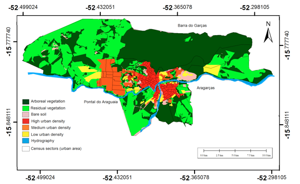
In this map were marked sites with more dense, medium and low urbanization, as well as arboreal and residual vegetation.
The other map drawn up relates to the variable declivity, considered crucial to the analysis of geological risks. Thus, the map was generated with percentage declivity by slope tool (3D Analyst) of Arcgis software. Five classes were defined: up to 05%; 05 to 10%; 10 to 20%; 20% to 30%; and above 30% (Map 2).
Map 2 – Declivity map of the Barra do Garças city and nearby cities: Pontal do Araguaia and Aragarças.

On Map 2 it was possible see that most census tracts has a low slope, and the areas with higher slopes are located in the northern portion of the Barra do Garças.
Then, through the crossing of the intersection of the slope classes 10 to 20% and over 20% with the Land use and vegetation cover map, it was possible to develop the environmental vulnerability map as to geological hazards (Map 3).
Map 3 - Geological hazards in the Barra do Garças city and nearby cities: Pontal do Araguaia and Aragarças.
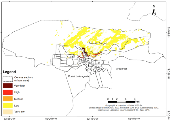
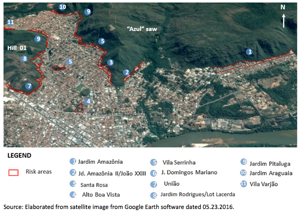
It is found that the Barra dos Garças city has significant implications as to geological hazards. This is because various city neighborhoods are delimited by the “Azul” saw or have hills with steep slopes on the inside, as shown in Figure 1.
Figure 1 – Risk areas in the Barra do Garças city.
According Colturato & Penteado (2013), natural conditioning factors of the mass movement processes were recorded in these neighborhoods and include, from relief escarpment and talus [2] with high slopes, the presence of sedimentary and tectonic structure that establish weakness regions to the exposed rocks, and other factors. Added to these natural constraints, the anthropic conditions, such as: deforestation, cuts made in the rocks and talus deposit, landfills occupation, improper disposal of solid waste, debris and waste water directly on the slopes, etc.
According to the authors, there are indicative features of the occurrence of the movement processes such as cracks in walls and building floors, landslides scars on the walls of the slopes, sloping structures such as poles, energy patterns, presence of blocks rolled in talus deposits detached from the walls of the escarpment, as well as reports of residents who witnessed the occurrence of these processes in these areas. In relation to social and economic consequences of these processes, there is no record of loss of life, however, there are many records of material losses and unpleasant experiences of the residents from situations which, for some, could have been worse and could have fatal victims.
In total, there are 11 neighborhoods at risk areas: Jardim Amazônia; Jardim Amazônia II, Jardim Pitaluga, Jardim Araguaia, Jardim Rodrigues, Jardim Domingos Mariano, Santa Rosa, Vila Serrinha, Vila Varjão, Alto da Boa Vista and União. These indexes can be viewed by the Map 4.
Map 4 - Geological hazards in the Barra do Garças city.
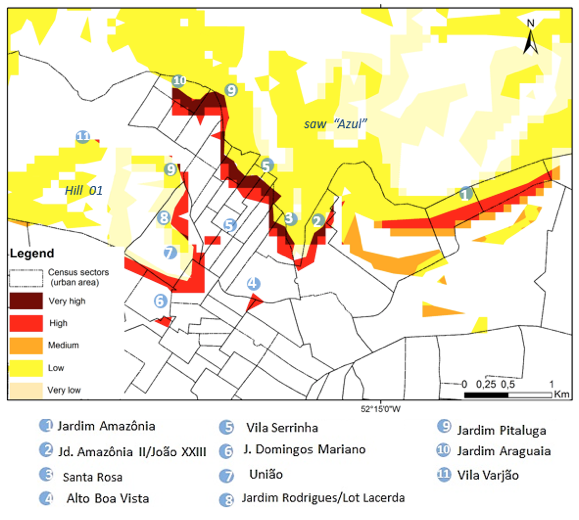
In Map 4, there is very high and high vulnerability, as the geological hazard, located in the areas that surround Azul saw and the larger hill (Hill 01). It was alsoverified high vulnerability areas that are located on smaller hills.
It is reported below, more relevant records on the areas that have very high and high vulnerability as the geological hazards.
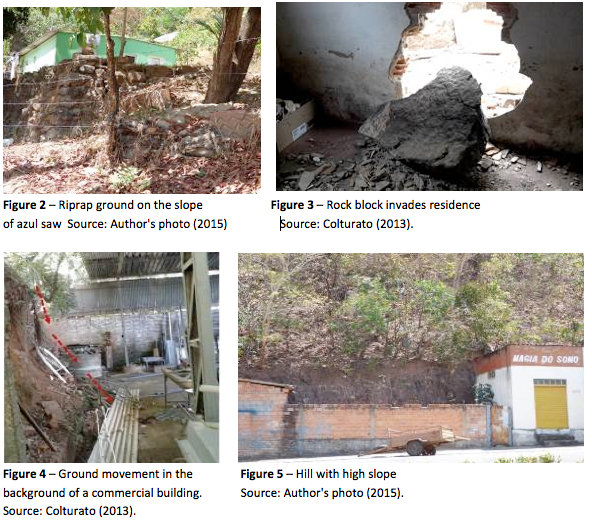
In area 9, belonging to Jardim Pitaluga, it was observed, several anthropogenic interference in the region such as: deforestation, burning, riprap to contain ground movement at the base of slopes (Figure 2), support wall improvised on hillsides, cut into mountain slopes with high declivity of the slope, as well as the presence of slope instability. According to Colturato (2013), in the northern part of the neighborhood, near to azul saw, residents report having witnessed more than once events related to mass movement, as falling blocks, and one of these events occurred at the end of 2012. In this phenomenon, a large proportion of the block has reached the wall of a house (Figure 3).
In the southern portion of the neighborhood, near the Hill 01, there is landslide risk due to the large declivity of the land and the slopes cuts angles that are very steep. The Figures 4 and 5 show, respectively, the background of a commercial building that several times, was hit by landslide and acute angle slope cut in the bottom of a building.
As in Jardim Pitaluga neighborhood, the buildings that are on the slopes of azul saw, neighborhoods Jardim Araguaia, Jardim Amazônia, Vila Serrinha and Santa Rosa are also plagued by risks arising from falling blocks that give off the sandstone formation of escarpments of azul saw (Figures 6 and 7). According to Colturato & Penteado (2013), in the Jardim Amazônia neighborhood there is a report of block fall occurred in the early 90. This fall destroyed the kitchen of a house, but not killed people because the people were not present in the room affected at the time of the fall. Other similar reports are common in these neighborhoods.

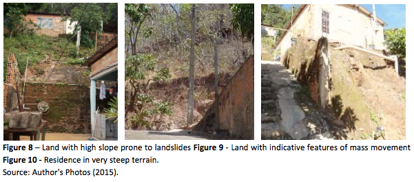
The area 08 belonging to Jardim Rodrigues and Lacerda allotment is a place with serious risks of slips, since it has many indicative features of mass movement processes (Figure 8 and 9). In the occupation of the neighborhood, residents were making cuts without the necessary technical guidance. There is the presence of features of instability, scars movements, cracks in buildings and signs of wastage. The surplus of the cuts are used in landfill along with materials unsuitable for this purpose, and the slope of the plots is mostly higher than 40° (Figure 10).
Most of the buildings was built in masonry, however, there are some houses built with wooden material, metal and others, and that enhances the vulnerability of people living there (Figure 11). Many residents do not have enough conditions or information to achieving containment methods, and improvise with their own methods. (Figure 12)

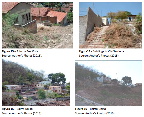
The presence of land with slopes above 10%, areas of instability and without vegetation and mass movement occurrences are also features present in other neighborhoods like Alto da Boa Vista (Figure 13), neighborhoods Vila Serrinha - central area (Figure 14) and Bairro da União (15 and 16).
The lack of urban planning, allied to social exclusion, induces large populations to deploy their homes in places that do not meet the minimum safety conditions. The aspects related to human action allied to natural phenomena result in a series of geological risks. This is the context of the areas demarcated in these eleven neighborhoods of Barra do Garças - MT.
Throughout the field research and data analysis, it was observed that the mass movement processes on the slopes of azul saw and hills is a common occurrence, and even seen naturally by the residents who live in vulnerable areas in the city of Barra do Garças.
Although these people reside in those regions exposed to geological risks, it was not found an adequate management or even effective monitoring of this area, which, due to the inertia of those involved as well as the expressionless performance of the government, potentiates the occurrence of natural events which can cause damage to property and lives of others.
Therefore, it is of fundamental importance that the risk areas are properly mapped and monitored through public policies that aim to immediate action and medium-term projects aimed at vacating of certain areas and intervention to prevent or mitigate the occurrence of harmful events; which in fact reduces vulnerability and increases resilience of those involved. And it is in this aspect that is fundamental the public awareness of the risks to which they are exposed.
BECK, U. (1992). Risk society: towards a new modernity. Londres: Sage Publications.
CARDONA, O. D. (2001). La necesidad de repensar de manera holística los conceptos de vulnerabilidad y riesgo: una crítica y una revisión necesaria para la gestión. Bogotá: CEDERI.
CERRI, L. E. (1998). Riscos Geológicos. In: OLIVEIRA, A. M. S.; BRITO, S. N. A. (eds). Geologia de engenharia. (pp. 301-310). São Paulo: Associação Brasileira de Geologia de Engenharia.
COLTURATO, S. C. O. (2013). Caracterização da ocupação de áreas legalmente protegidas e de áreas de risco na cidade de Barra do Garças - MT e impactos ambientais associados. Projeto de Pesquisa. Barra do Garças: Universidade Federal de Mato Grosso.
COLTURATO, S. C. O.; & PENTEADO, R. H. R. (2013). Riscos geológicos associados à movimentos gravitacionais de massa na cidade de Barra do Garças, MT. In: III SEMANA CIENTÍFICA DO CAMPUS UNIVERSITÁRIO DO ARAGUAIA. Anais...Barra do Garças: UFMT.
FLORENZANO, T. G. (2008). Cartografia. In: FLORENZANO, T. G. (Org.). Geomorfologia: conceitos e tecnologias atuais. (pp.105-127). São Paulo: Oficina de textos.
FURTADO, J. et al. (2012). Capacitação básica em defesa civil. Universidade Federal de Santa Catarina. Centro Universitário de Pesquisa e Estudos sobre Desastres. Florianópolis: CAD UFSC.
MARANDOLA, E. (2005). Catástrofes naturais e as percepções sobre seus riscos e perigos. Disponível em: <http://www.comciencia.br/entrevistas/2005/11/entrevista1.htm>. Acesso em: 13 ago 2014.
MINISTÉRIO DAS CIDADES. (2006). Prevenção de riscos de deslizamentos em encostas: guiapara elaboração de políticas municipais. Brasília: Ministério das Cidades
RIBEIRO, W. C. (2010). Riscos e vulnerabilidade urbana no Brasil. Scripta Nova. Revista Electrónica de Geografía y CienciasSociales, Barcelona, 14 (331), 65. Disponível em: <http://www.ub.es/geocrit/sn/sn-331/sn-331-65.htm>. Acesso em: 15 ago 2015.
SAITO, S. M. (2008). Desastres naturais: conceitos básicos. I Escuela de primavera sobre soluciones espaciales para el manejo de desastres naturales y respuestas de emergenciasinundaciones. Santa Maria: INPE-CR. Disponível em: http://www.inpe.br/crs/crectealc/pdf/silvia_saito.pdf. Acesso em: 16 jul. 2014.
WACHINGER, G. et al. (2012). The risk perception paradox – implications for governance and communication of natural hazards. Risk Analysis, 33(6), 1049-1065.
UNISDR (United Nations International Strategy for Disaster Reduction). (2004). Living with risk: a global review of disaster reduction initiatives. Gevena: United Nations.
VEYRET, Y. (2007). Os riscos: o homem como agressor e vítima do meio ambiente. São Paulo: Contexto.
1. Professora Adjunto I, Curso de Engenharia Civil - Campus de Barra do Garças – Universidade Federal de Mato Grosso - UFMT, doutora em Recursos Naturais pela Universidade Federal de Campina Grande – UFCG. Email: greycebernardes@yahoo.com.br
2. Unconsolidated rock deposit (incoherent and heterogeneous material) from weathered and moved by gravity material. It occurs at the foot of strong declivity of slopes or cliffs base (steep slope). The talus is unstable and can easily be unsettled, causing other mass movements..