![]() ISSN 0798 1015
ISSN 0798 1015

![]() ISSN 0798 1015
ISSN 0798 1015
Vol. 39 (Number 16) Year 2018 • Page 35
Kustysheva Irina NIKOLAEVNA 1; Skipin Leonid NIKOLAEVITCH 2; Petukhova Vera SERGEEVNA 3; Dubrovsky Alexey VIKTOROVICH 4; Martynov Olesya IGOREVNA 5
Received: 20/12/2017 • Approved: 20/01/2018
ABSTRACT: Land resources are one of the most important components of the biosphere, the material condition of life and activity of people, the basis for locating and developing all branches of the national economy and the main means of production in agriculture and forestry. Therefore, the organization of rational use and protection of land is an important condition for improving the life and welfare of the present and future generations. To prevent negative processes in the use of land resources, it is necessary to develop methods for effective land use. Decision-making on the implementation of actions on the ground must be preceded by an analysis of versatile and regularly updated data on its status and the dynamics of the development of negative processes. The relevance of this work is due to the fact that the organization of land monitoring, as an integrated system for monitoring the state of the land fund, assessing and forecasting its changes, is a global task of public administration in the sphere of environmental protection and rational nature management in general. The purpose of the study is to identify current problems in the process of implementing state monitoring of land and develop recommendations for improving the order of these works. |
RESUMEN: Los recursos de la tierra son uno de los componentes más importantes de la biosfera, la condición material de la vida y la actividad de las personas, la base para encontrar y desarrollar todas las ramas de la economía nacional y los medios básicos de producción en la agricultura y la silvicultura. Por lo tanto, la organización del uso racional y la protección de la tierra es una condición importante para mejorar la vida y el bienestar de las generaciones presentes y futuras. Para evitar procesos negativos en el uso de los recursos de la tierra, es necesario desarrollar métodos para el uso efectivo de la tierra. La toma de decisiones sobre la implementación de acciones sobre el terreno debe ir precedida de un análisis de datos diversos y regularmente actualizados sobre su estado y la dinámica del desarrollo de procesos negativos. La relevancia de este trabajo está relacionada con el hecho de que la organización del monitoreo de la tierra como un sistema integrado para monitorear el estado de la tierra, evaluando y prediciendo sus cambios es un objetivo global de la administración pública en el campo de la protección ambiental y la gestión racional de la naturaleza en general. El propósito del estudio es identificar problemas actuales en el proceso de implementación del monitoreo estatal de la tierra y desarrollar recomendaciones para mejorar el orden de estos trabajos. |

The idea of a global environmental monitoring of the natural environment and the term "monitoring" itself appeared in 1971 in connection with the preparations for the Stockholm UN Conference on the Environment. At the first Intergovernmental Monitoring Meeting (Nairobi, 1979), monitoring was used to refer to a system of repeated observations of one or more elements of the natural environment in space and time for certain purposes in accordance with a pre-prepared program (Stepanovsky AS, 2001 Chen X.W. , 2002).
The adoption of effective management decisions on compliance with land legislation depends primarily on the availability of accurate scientific evidence on the quality of land and the changes that occur there. The source of such data is land monitoring.
Monitoring is mainly technical and information and analytical work related to the use of technical means of monitoring the condition of lands, taking soil samples and conducting soil-geobotanical surveys, analyzes and measurements of the chemical and biological composition of soils, and their physical state. We can say that monitoring is simultaneously a measure of preventive, current and subsequent control (Damdin OS, 2012, Bogolyubova A, 2010).
State monitoring of land is an information system, the priority tasks of which are the preservation of natural ecosystems, the protection of human and social interests, the prevention of crisis changes in the state of land and the prevention of environmental emergencies in land use.
The solution of these most important tasks in the overall system of land management Resources should be carried out in several stages:
- collection of initial data on the state of the land fund by various methods and technical means of monitoring;
-conducting land quality assessment taking into account the interests of land users and maximizing their effective development for various functional purposes;
- development of economic and legal mechanisms preventing deterioration of the quality of land and complex measures for their protection;
- development of technologies and regulations for making managerial decisions in land management based on land monitoring databases (Varlamov A.A, 2009, Zharnikov V.B, 2015).
State monitoring, depending on the objectives of monitoring and territorial coverage, can be:
1) Global land monitoring: conducted in accordance with the International Geosphere-Biosphere Program "Global Change". It allows us to assess the current state of the entire natural system of the Earth in order to warn about emerging extreme situations. Observation is conducted by base stations in various regions of the planet, which are often located in biosphere reserves;
2) Federal land monitoring: covers the entire territory of the state, providing necessary observations on the state and use of federal property lands, territories of regions with critical ecological condition of lands, significant for national security of the country;
3) Regional land monitoring: covers territories within the region, that is, territories that are limited by physical, geographical, economic, administrative and other boundaries;
4) Local monitoring of land: conducted at sites below the regional level, within the boundaries of settlements, up to the territories of individual land uses, land plots where observations of the state and use of land of different forms of ownership are necessary for regulating land use and land relations.
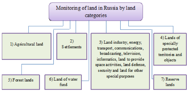
At each territorial level, land monitoring can include the following subsystems, for example in Russia for the relevant land categories (Fig.1).
Fig. 1
Monitoring of land by category
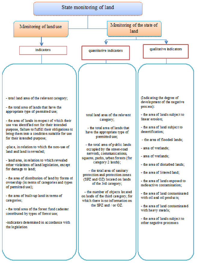
Depending on the purpose of the monitoring, the state monitoring of lands is divided into two types (Fig. 2).
Each object of state land monitoring is described by a set of indicators that determine its state and use (Varlamov A.A, 2009).
Within the monitoring of land use, land use is monitored in accordance with their designated purpose, and monitoring of the state of lands is monitoring changes in the quantitative and qualitative characteristics of lands, assessing and forecasting changes in the state of land. Assessment of the state of land is carried out by analyzing a series of consecutive observations, the direction and intensity of the changes and comparing the obtained indicators with the values of the baseline observation and the normative index.
Indicators of the state of land are expressed in both absolute and relative values, assigned to a certain period.
Based on the results of the assessment of the state of the land, forecasts and recommendations are compiled with thematic maps, diagrams and tables describing the dynamics and direction of the development of the changes, especially those of a negative nature.
Information obtained from the monitoring of land use is used in the implementation of state land supervision to provide government authorities, local governments, organizations and citizens with information on land use.
The data obtained during the state monitoring of lands are used in the preparation of the state (national) report on the state and use of land in the country (Order of the Ministry of Economic Development, 2014, Comments to the Land Code, 2016).
Since the main task of land monitoring is to monitor the quality of land as a natural site, actions to implement land monitoring should be compared with environmental monitoring in general (Akros, 2014).
Fig. 2
Types of state monitoring of land, depending on the purpose of observation
In order to protect land resources and the environment in general, to prevent land pollution, ensure their productivity, improve and introduce new technical means and technologies of land monitoring, as well as informational support of the power structures on the state of land, it is necessary to solve the following tasks:
1) timely identification of changes in the state of land, assessment and prediction of these changes, development of proposals for preventing negative impacts on land, on eliminating the consequences of such impacts;
2) provision of public authorities with information on the state of the environment with regard to the state of land in order to realize the powers of these bodies in the field of land relations, including the exercise of powers under state land supervision;
3) provision of local self-government bodies with information on the state of the environment with regard to the condition of lands in order to realize the powers of these bodies in the field of land relations, including municipal land control;
4) provision of legal entities, individual entrepreneurs, citizens with information on the state of the environment in part of the state of land.
The goals and objectives of land monitoring are determined by the following principles of its management:
1. The principle of mutual compatibility and comparability of disparate data, which is based on the use of unified classifiers, formats, data of the regulatory and technical base, a single state system of coordinates and heights. This is the main principle of land monitoring;
2. The principle of the unity of methods and technologies monitoring of land;
3. The principle of reliability and accuracy - the compliance of land monitoring data with the actual state and use of the land fund;
4. Principle of completeness of monitoring information - the information should be complete and sufficient for solving specific problems;
5. Principle of continuity of land monitoring;
6. The principle of visibility (the use of maps, atlases, schemes);
7. The principle of accessibility (with the exception of information constituting a state or commercial secret);
8. The principle of economy and efficiency (application of methods, technologies, methods ensuring the receipt, systematization and storage of land monitoring data);
9. The principle of centralized leadership (monitoring by a uniform methodology on the scale of the Russian Federation and from a single center) (Varlamov A.A, Galchenko S.A, 2013)
The methods of obtaining information in the implementation of state monitoring of lands that are carried out during the state monitoring of lands, depending on the period and periodicity of the conduct are divided into three types (Fig. 3).
Fig. 3
Types of surveys/observational/remote sensing
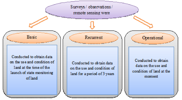
When preparing the final materials of the state land monitoring, it is indicated which types of surveys, observations and remote sensing were used.
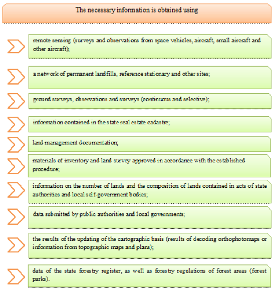
The necessary information for the implementation of state monitoring of land can be obtained in various ways (Fig. 4).
The sources of information on the works carried out to study the state of land are documents received by the state data fund obtained as a result of the land survey in the course of the calendar year, as well as data on the work carried out on the study of the state of land received from state and local government bodies upon request , From other official information resources.
In accordance with the state contract on the topic "Identification of changes in the state of land in the territory of the «Nizhnetavdinsky» landfill in the Tyumen region and the development of recommendations for preventing and eliminating the consequences of negative processes," work was carried out to analyze the state of land at the federal landfill. In the process of work, developing negative processes and their causes are analyzed, maps of the dynamics of erosion and overgrowing of agricultural lands are drawn up, a forecast is given for the development of negative processes, economic damage caused by the degradation of land due to erosion and overgrowing is assessed. The revealed negative phenomena on the condition of the soil cover and the use of lands in the territory of this range are the basis for developing recommendations for the prevention and elimination of the consequences of negative processes.
Fig. 4
Sources of information in carrying out the state monitoring of lands
The obtained materials and data of the state monitoring of lands are accumulated and stored in the archives (databases) and databases of the automated information system of state land monitoring (Izrael Yu.A., 1990, Giniyatov IA, 2012, Buchnev A.A., Kim P.A., Pyatkin V.P., 2016).
The forecasts and recommendations for eliminating the negative manifestations presented in the reports are mostly formal and can not be applied to a specific situation for making management decisions. There are no mandatory administrative procedures that take into account the monitoring results. There was no tangible effect on the federal or regional level from the work done.
Unfortunately, according to the results of the monitoring program, no official regulations were adopted. So, the Unified system of indicators of state land monitoring for all categories of land was only approved by the Scientific and Technical Council of Roszemkadastra in 2003 (later it was finalized and sent to the territorial bodies of Rosnedvizhimost for use by letter No. VK / 0013 dated 11.01.2006). Currently, only indicators for monitoring the use and condition of land have been developed.
In addition, it should be noted that no monitoring is carried out on agricultural land.
Based on all of the above, it can be concluded that the implementation by the Federal Service of Cadastre and Cartography of land monitoring in the absence of an officially adopted system of indicators and a regulatory and technical base seems inexpedient and ineffective. It is impossible to establish reasonable requirements for the results of monitoring work and determine the scope of such work. Otherwise, the planned monitoring work at this point in time can be recognized as work leading to inefficient and partially untargeted spending of the federal budget.
Having studied and analyzed the problems of state land monitoring in the Russian Federation the Tyumen region, the following drawbacks of the existing system in this area can be noted:
1) Lack of relevant normative legal acts in the field of state monitoring of lands, as a result of which parameters have not been determined, as well as requirements for the content and structure of data to be obtained in the process of monitoring land at different levels (federal, regional and municipal).
Existing regulatory legal regulation is usually limited to a list of specific activities, surveys, works, remote sensing, which should be listed in relation to the land of a certain category in a certain territory.
Considering the huge importance of the land as a natural resource, which is simultaneously an object of real estate and bearing in mind that the data obtained during the monitoring of lands are used in the conduct of the State Real Estate Cadaster, land management, in developing plans for appropriate land reclamation activities and For other purposes, it is necessary to update the regulatory framework for land monitoring.
2) Lack of methodological and normative-technical documents regulating land monitoring and systematization of its data.
3) The list of federal bodies of state power exercising functions in the field of state monitoring of lands and, accordingly, their functions in this sphere are not established in the existing normative legal acts (the list of bodies performing certain types of work, the collection of certain data, their systematization)
4) Lack of normative and legal regulation of the mechanism of interaction of power structures, including interaction of automated information systems.
Based on the importance and significance of land monitoring for the subjects of the Russian Federation and municipalities, it is necessary to legislate the powers of the RF, RF subjects and municipalities in the regulation of monitoring land in the relevant territory.
The subject of the Russian Federation and municipalities should be given the right to establish in their acts the types, financing order and objectives of monitoring the lands in their territories, the list of performers, the frequency and timing of the conduct, a list of studies relevant to the natural, climatic, socio-economic characteristics of the territory.
In order to formulate and improve the system for implementing land monitoring in the Russian Federation and to improve the regulatory framework, it is advisable to adopt the targeted program "Development of state land monitoring in the Russian Federation", which would determine the main directions for the development of land monitoring in the Russian Federation, and in which, as program activities Would include:
1) Adoption of the necessary regulatory legal acts governing the implementation of the state land monitoring, interaction between federal executive authorities that differentiate their competence, as well as acts that establish and demarcate powers between the Russian Federation, constituent entities of the Russian Federation and municipal entities in the field of land monitoring and their adoption of regulatory legal acts , Regulating the state monitoring of land at an appropriate level;
2) Creation of a sustainable system of bodies (and organizations) that allows continuous and systematic monitoring of land;
3) Establishment of a unified system of methodological and technical standards to ensure compatibility of information obtained during the monitoring of lands held at various levels obtained by various federal executive bodies and their territorial bodies when they monitor other types of natural resources;
4) Adoption of targeted programs by the subjects of the Russian Federation aimed at developing monitoring of lands in their territories;
5) Equipping the relevant bodies (and organizations) with the technical means necessary to implement appropriate measures, the implementation of which is mandatory in the process of bringing land monitoring, as well as the means for the data fund, storing and processing information and maintaining the Data Foundation obtained during land monitoring (Moskvin V.N., Zharov A.V., 2012, Organizational Structure of Monitoring, 2015).
In order to ensure the consistency of the indicators used in monitoring land, as well as the harmonization and compatibility of various indicators when monitoring other types of natural resources, a monitoring system is proposed that includes three subsystems and a control unit (Fig. 5).
Fig. 5
The block diagram of the system of monitoring of lands
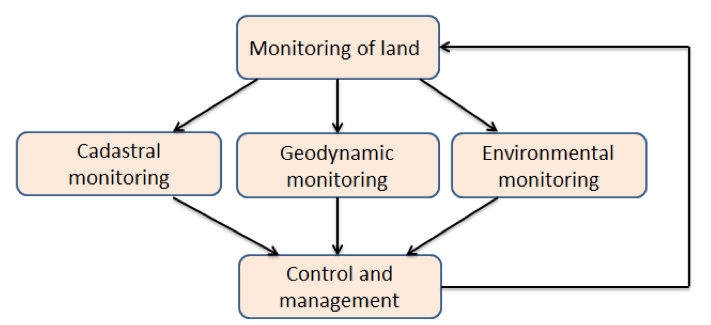
Cadastral monitoring organizes and conducts observations on changes in cadastral information, which include: a change in the category of land; Change in the form of ownership; Change of ownership; Change in the form and area of land; Changing the legal regime; Change in cadastral and market value; Change allowed use.
Functions for the organization and management of cadastral monitoring of land should be assigned to the units of the Federal Cadastre and Cartography Service.
Geodynamic monitoring organizes and conducts geodetic, geodynamic, seismological, geological and gravimetric observations of: suffosion processes; Erosion processes; Landslides; Collapses; Karst phenomena; Volcanic activity; Zones of earthquakes; Sedimentary and deformation processes.
In this case, the nature of the listed processes and phenomena can be both natural and technogenic.
Functions on the organization and management of geodynamic monitoring should be placed on the former "Roskartografiya", which has a lot of experience in the field of geodynamics and now enters the structure of the Federal Service of Cadaster and Cartography.
Ecological monitoring of lands organizes and monitors changes in such soil indicators as: mechanical composition; grading; Humus content; acidity; Carbonate content; Flooding, bogging and desertification; Salinity; Contamination with pesticides, heavy metals, radionuclides and other harmful substances.
Modern IT-technologies, methods of remote sensing,
GPS-positioning, laser scanning can collect monitoring information almost in real time. To store, process and transmit information about the state of land, it is necessary to create a
single monitoring research center, the structure of which is shown in Fig. 6.
Fig. 6
Block diagram of a single monitoring center
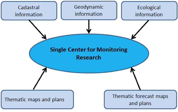
Analysis of thematic and forecast maps and plans will allow not only to assess the state of land, but also to make effective decisions on spatial planning, land management, calculate scientifically justified cadastral and market value of land, improve the taxation system, and more efficiently and rationally use the land fund Russian Federation (Galant K., 2008).
To improve the legal support for state monitoring of land, it is necessary:
- to develop a number of methodological and normative technical documents by the Federal Service of Cadastre and Cartography that specify the procedure for conducting and implementing land monitoring, collecting, processing, providing information, etc.;
- formation of legal and organizational mechanisms (information exchange, automated technologies, etc.);
- the development of the State Land Monitoring Program and the corresponding Government Decrees, in accordance with which this type of activity will be financed and implemented at the federal and regional levels.
The results of the work should provide opportunities for further improvement of the Federal Service for Cadastre and Cartography of activities for monitoring land (Sladkopevtsev S.A., 2008).
For the development of state land monitoring, including as the main information source of the country's land resources management system, it is necessary to develop normative legal documents that would be determined by the purpose of monitoring land as an obligatory periodic activity to assess the status and actual use of different territorial entities from a separate land Site to the country with the formation of a database of results, their storage and access to them. At the same time, implementation of these requirements will be important for the formation and maintenance of the cadastre system, as well as for a number of other land information systems, such as the land valuation system, the system for monitoring the status and use of land resources, the system for the formation of the National Report on the Land Fund of Russia.
1. Bogolyubova A. Monitoring of the land of Yuntolovo Reserve // Proceedings of the XV International Conference at the Wroclaw University of Environmental and Life Sciences. Wroclaw, Poland, 2010. P. 85.
2. Buchnev A.A., Kim P.A., Pyatkin V.P. Cloud Calculations In Processing Remote Sensing Of The Earth: Interexpo Geo-Siberia - 2016. XII Intern., Cor., T. 4 №1 Remote sensing methods of the Earth and photogrammetry, environmental monitoring, geoecology. Novosibirsk April 18-22, 2016 with. 68-72
3. Varlamov. A.A. Theory and methods of maintaining state monitoring of lands as an information basis for the state real estate cadastre: monograph; State University of Land Management. - M., 2009. - 290 p.
4. Varlamov A.A., Galchenko S.A., Klyushin P.V. The organizational and economic mechanism for the restoration of degraded soils: monitoring. - Moscow: State Educational Institution, 2013. - 236 p.
5. Galant K. Analysis of images as an instrument of spatial layout. Materials of the 10th professional conference of graduate students "JUNIORSTAV 2008", Brno, Czech Republic, 23.01.2008.
6. Giniyatov I.A., On the nature and role of state land monitoring at the present stage. Collected Works 4 International Scientific Conference "Economic Development Of Siberia And The Far East: Economics Of Natural Resources, Land Management, Forest Management, Real Estate Management" - 2012, Novosibirsk, T.3 №1, p. 43-46.
7. Damdin O.S. The concept, objectives and types of land monitoring: A young scientist. - 2012. - №1. T.2. - from. 165-166.
8. Zharnikov V.B., Evsyukova I.N., Safronov V.V. Land monitoring as the main mechanism of information support of infrastructure for sustainable development of territories http://cyberleninka.ru/article/n/monitoring-zemel-kak-snovnoy-mehanizm-informatsionnogo-obespecheniya-infrastruktury-ustoychivogo-territoriy-Development
9. Yisrael Yu.A. Philosophy of monitoring // Metrology and hydrology. - 1990. - No. 6. - p. 5-10.
10. Moskvin V.N., Zharov A.V. Analysis of the methods of estimation of use of natural resources with the account of environmental security of the territory. Collected Works 4 International Scientific Conference "Economic Development Of Siberia And The Far East: Economics Of Natural Resources, Land Management, Forest Management, Real Estate Management" - 2012, Novosibirsk, T.3 №1, p. 123-128.
11. Sladkopevtsev S.A. Nature management: a textbook. - Moscow: MIGAIK, 2008. - 162 p.
12. Stepanovskiy A.S. Ecology: a textbook.-М.: UNITY-DANA, 2001. 703 p.
13. Chen X.W. The use of remote sensing and GIS to analyze changes in land cover and its impact on sustainable regional development. International Journal of Remote Sensing. 2002. № 23. p. 107-124.
14. Order of the Ministry of Economic Development of Russia from December 26, 2014 № 852 "On approval of the Procedure for the implementation of state monitoring of lands, with the exception of agricultural land." Http://base.garant.ru/70869020/ .
15. Report on the status and use of land in the Tyumen region in 2015: Office of the Federal Service for State Registration, Cadastre and Cartography in the Tyumen region.
16. Akros Article "Actual problems of the implementation of the Rosreestr of State Land Monitoring" http://484284.ru/novosti/statya-aktualnye-problemy-osushchestvleniya-rosreestrom-gosudarstvennogo-monitoringa-zemel/ .
17. Monitoring of land at the present stage http://cyberleninka.ru/article/n/monitoring-zemel-na-sovremennom-etape .
18. Commentary to art. 67 ЗК РФ http://stzkrf.ru/67 .
19. Organizational structure of monitoring http://www.life-prog.ru/2_78776_organizatsionnaya-struktura-monitoringa.htm State Registration, Cadastre and Cartography in the Tyumen region.
1. Tyumen Industrial University, Volodarsky Street, 38, Tyumen, Russia. Contact Email: irina1983kust@gmail.com
2. Tyumen Industrial University, Volodarsky Street, 38, Tyumen, Russia
3. Tyumen Industrial University, Volodarsky Street, 38, Tyumen, Russia
4. Siberian State University of Geosystems and Technologies, Novosibirsk, Russia
5. Siberian State University of Geosystems and Technologies, Novosibirsk, Russia