![]() ISSN 0798 1015
ISSN 0798 1015

![]() ISSN 0798 1015
ISSN 0798 1015
Vol. 39 (Number 18) Year 2018 • Page 9
Naú Silverio NIÑO Gutiérrez 1
Received: 31/12/2017 • Approved: 20/01/2018
ABSTRACT: The objective, was showing the economic activities which make sustainability at “El Hondo” Natural Park possible. The method, based on the principle of Landscape Geography during its development, the method implicitly had the following global activities: office work and field work, the technic that supported this phase was participant observation. Result, the importance is expressed by the diversity of migratory birds and the conclusion show that tourism and leisure activities are threatened by the evaporation of the wetland. |
RESUMEN: El objetivo fue mostrar las actividades económicas que hacen posible la sostenibilidad en el Parque Natural "El Hondo". El método, basado en el principio de Geografía del Paisaje durante su desarrollo, implícitamente tuvo las siguientes actividades globales: trabajo de oficina y trabajo de campo, la técnica que apoyó esta fase fue la observación participante. Resultado, la importancia es expresada por la diversidad de aves migratorias y la conclusión muestra que el turismo y las actividades de ocio están amenazadas por la evaporación del humedal. |

Among the most threatened natural ecosystems in the world are wetlands, as a result of human economic activities on the one hand and climate change, which affects size, structure, hydrology and biota. It is in the Spanish southeast where the most important semi-arid regions are located, because it is home to a large number of wetlands that allow the accumulation of water and formation of important lake systems that have received attention in various publications (Niño-Segrelles-Niño-Niño, 2015; García-Pagani, 2016 y García 2017). Where the natural landscapes decreed as protected natural areas under the jurisdiction of National Parks protects terrestrial and aquatic flora and fauna of interest, with a high diversity of species, in this case it also corresponds to an important route of bird migration between Africa and Europe.
The goal of this research was the critical analysis of the physical, geographical and touristic conditions which make the use and management of “El Hondo” Natural Park possible. The elements of the methodology which supported the study were the ecological, geographical and economical approaches enriched with statistical and cartographic technics, as well as participant observation. Thus, the natural landscape is represented by a wetland area, located in Alicante, which has a total area of 2,387.2 hectares, surrounded by the Crevillente, Callosa and Orihuela sierras.
The natural scenic beauty of “El Hondo” Natural Park is related to the great ecological and economical interest about the water which comes from the Segura river´s reservoirs. Almost 40,000 hectares located in the area between San Juan and Orihuela are irrigated by them. The park´s extreme geographical coordinates are: 38° 10’ 00’’ to 38° 13’ 00’’ north latitude and 0° 44’ 00’’ to 0° 47’ 30’’ west longitude of Greenwich. Tourism is the most important activity in that spot. That is why the park´s administration has specifically set observatories among reeds and tarays (typical vegetation found in salt marshes) so the visitors can observe the local avifauna without disturbing its mobility. Such practice is developed along with other types of land use such as fishing, hunting, farming and stockbreeding.
One of the preliminary conclusions that can be mentioned is the fact that the natural park constitutes an agricultural system with its own right. It has an incalculable cultural value for the inhabitants of Crevillente, San Felipe Neri, Santa Pola and Mata-Torrevieja. In addition, the information center is complete for bird observation, since it has the necessary infrastructure and equipment for “in situ” observation worthy of a Site of Community Importance (LIC: Localidad de Importancia Comunitaria), which is regarded a Special Bird Protection Area (ZEPA: Zona de Especial Protección para las Aves) by the European Community (García & Pagani, 2016).
The urban, residential and commercial land use is gaining territorial extension regarding the dynamic relationship that has to do with urban and economic activities carried out by man in peri-urban areas. That is not the case of land use related to agriculture, stockbreeding, hunting, fishing and nature tourism, which are supported on the presence of sui generis landscapes, increasingly scarce.
In light of these problems, leisure and recreation activities for the inhabitants must excel, so they amuse themselves in some Natural Protected Areas (ENP: Espacios Naturales Protegidos), where Natural Parks such as “El Hondo” play an important role. It was decreed a Natural Protected Area on April 2, 1979 as a Bird Protection Special Area (ZEPA: Zona Especial de Protección para las Aves). Even the Generalitat Valenciana decreed “Hondo” a Natural Area in 1988 in order to promote the tourist use of the spot in the Levante and Poniente reservoirs, besides keeping the traditional farming, stockbreeding, hunting and fishing use in the surrounding area.
On the other hand, changes in precipitation from the Spanish Mediterranean, along with the population expansion in Orihuela and Crevillente, make the existence of reservoirs more difficult every time. The extension of the body of water that comes from Segura river decreases year by year to a greater or lesser degree causing pollution where bird observation takes place by visitors from Europe and Spain. Wet areas have traditionally been mistreated; “their loss of water, pollution and degradation have led them to a gloomy and irreversible state” (Natural Resources Consulting Office, 2012). Then, wetland tourism becomes an economic activity defined by the presence of water, since it is a natural refuge for local, migratory and endemic birds such as the White-headed Duck (Oxyura leucocephala), nowadays endangered, the Ruddy Duck (Oxyura jamaicensis) and “Focha cornuda” (Fulia cristata), currently in danger of extinction (Figure 1).
Figure 1
“Focha cornuda”
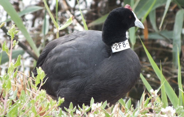
Source: Field work, 2016.
Main goal. Showing the economic activities which make sustainability at “El Hondo” Natural Park possible.
Research question. What are the activities that make sustainability at “El Hondo” Natural Park possible?
The method. Based on the principle of Landscape Geography, the method that was applied on this occasion covered the area explicitly referred to “El Hondo” Natural Park.
During its development, the method implicitly had the following global activities: I) Office work. It largely comprised the consultation of specialized printed literature on certain topics such as natural parks, protected natural areas, environmental legislation, tourism, digital material about natural parks and the Generalitat Valenciana’s cartography. In order to carry it out, some libraries of Alicante University and the Information Center of “El Hondo” park were consulted. That information was processed at the Human Geography.
Department of Alicante university, where the following activities were realized: a) design and provisional construction of a base map and thematic cartography; b) statistical data processing and its concentrated representation on charts and graphs; c) definitive design and construction of thematic maps; d) explanatory text and e) final writing of the text.
II) Field work. It included eight exploratory and verification tours, three of them were carried out from September to November, 2015 and five of them from January to May, 2016. The main tasks included the geographic update of recreational routes and sites for bird observation. A total of 65 people were interviewed, two professors from Alicante who are frequent visitors, three park employees and 60 visitors. 46 were occasional visitors and 14 frequent visitors. Besides, i) taking pictures of several aspects of the park; ii) video recording which captured the biophysical and human characteristics in the park; iii) four lectures were given to students of the Master’s Degree in Geography and land-use Planning at Alicante University. They were about multifunctionality and the tourism practiced in the Natural Parks of the Valencian Community, in particular “Carrizales” and “El Hondo”.
Field work was carried out in three phases: the first one included the compilation, reading and analysis of the published material, printed and digital, about “El Hondo” Natural Park. The second phase was the cartographic processing, which was carried out in order to show a physical and geographic survey of the area of study based on the thematic mapping whose methodology has been applied in Mexican latitudes (Melo and Niño, 2003; Melo and Castillo, 2008).
The third phase involved the processing of tourist information, which included a sample of 65 visitors, 46 of them occasional visitors and 14 frequent visitors during the eighteen tours that took place from September to November, 2015 and from January to May, 2016 in order to confirm the high arrival of visitors in those periods of time, as well as the origin and motive of the visitors interested in the park’s public use, where it was necessary to gather information such as the favorite places and areas where visitors practice intensive-active recreation. The technics that supported this phase was participant observation (Babbie; 2000). The information gathered is very similar to the profile of the tourist who visits “El Hondo” Natural Park. It was elaborated by Alicante University’s academics from 2009 to 2011, but the visitor’s profile is still valid today (Generalitat Valenciana, 2011).
It is located southeast of Spain. It borders Teruel to the north, Tarragona to the northeast, Cuenca to the northwest, the Mediterranean Sea to the south and southeast and Albacete and Murcia to the southwest. In order to comply Council rule 92/43/CEE set on May 21, 1992 related to the conservation of natural habitats and wildlife, the Valencian legislation allowed to favor the maintaining of biodiversity. At the same time it takes into account the actual economic, social, cultural and regional demands in a favorable state of conservation known as European Ecological Net “Red Natura 2000” in which each country in Europe designated wildlife places and areas which are important for the world conservation in order to: a) build a representative net of the main natural ecosystems and regions and b) protect natural areas and elements that offer a particular interest from the scientific, cultural, educational, aesthetic, scenic and recreational point of view (De La Vega, 2010).
In that sense, the Generalitat Valenciana decreed (187/1988) “El Hondo” a Natural Area according to article 96 of the Constitution and article first of the Civil Code, and its inclusion, by the Spanish government on the list of international-concern wetland areas established in RAMSAR covenant, has the character of wet area for the purposes provided in article 103 of the Water Law and article 3 of Law 5/1988 (June 24) of Natural Areas of the Valencian Community and Law 11/1994 of Natural Spaces of the Valencian Community. “El Hondo” is also a Bird Protection Special Area (ZEPA: Zona Especial de Protección para las Aves), according to council rule 79/409/CEE, April 2, 1979, concerning the conservation of wild birds (Ibídem, 2010, p. 30).
Figure 2
Location
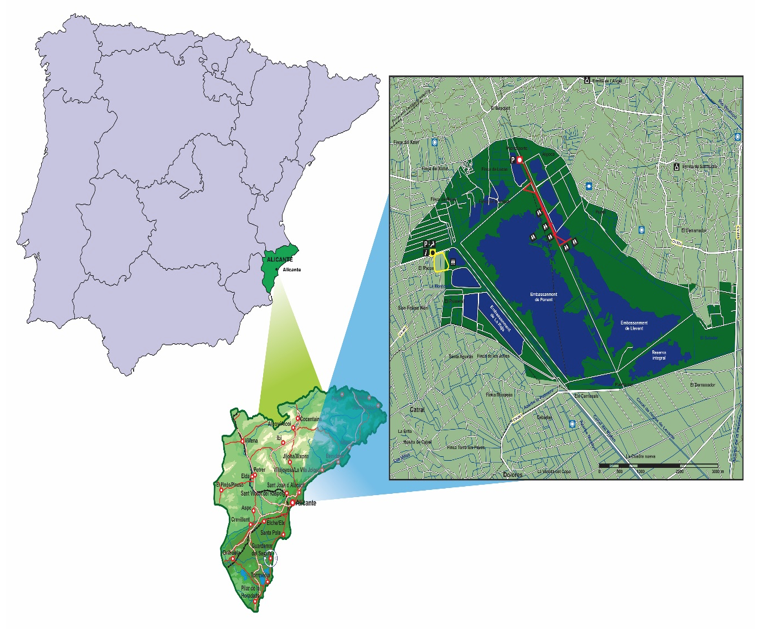
Source: own elaboration, 2017.
It is located in the municipality of Alicante, it has a total area of 2,378.2 hectares. It is surrounded by the Crevillente, Callosa and Orihuela sierras, in a tectonic depression called Elche plain located south of Baix Vinalopó, district of Alicante. It is near Santa Paola salt marshes, with which it has a common origin (Andarías, 1996).
Figure 3
Regional influence of Alicante
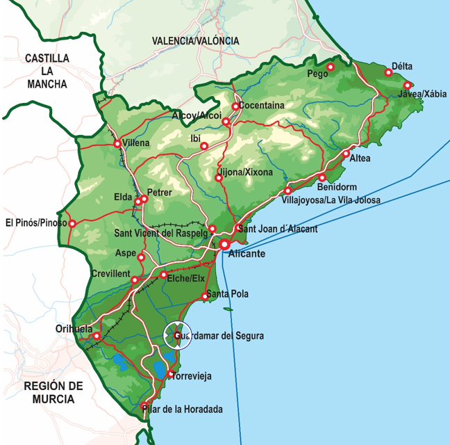
Source: Generalitat Valenciana, 2013.
This wet-land spot holds a major ecological and economic interest. Nearly 40,000 hectares in the area located between San Juan and Orihuela are irrigated by the water from the reservoirs which comes from Segura river (Generalitat Valenciana, 2011).
Segura river (Tader, in Latin) starts at Segura Sierra, near Fuente Segura (Jaén), a small village. It flows into the Mediterranean Sea, in Guardamar de Segura (Alicante), after running 325 kilometers. It is one of the rivers with the highest hydraulic exploitation, also known for its irregularity, since it has caused great flooding alternated with long dry spells (Crespi and Planells, 2011, p. 24).
It is multifunctional, since activities such as environmental education and monitoring and research, scientific monitoring, bird observation, farming, hunting and fishing are carried out in a series of interesting wet spots linked to the reservoirs, besides the salt marshes that surround it. The park’s extreme geographical coordinates are: 38° 10’ 00’’ to 38° 13’ 00’’ north latitude and 0° 44’ 00’’ to 0° 47’ 30’’ west longitude of Greenwich. “El Hondo” is a very important place, since it keeps a symbiotic balance as well as agricultural development, environment preservation and biodiversity in the boundaries of Pedanías de San Felipe Neri and Crevillente where there are other Valencian Community natural parks called Mata-Torrevieja and Las Salinas de Santa Pola.
Apart from the fact that it is necessary for the agricultural, livestock and forestry spaces to join the urban and rural territory creating a coherent balance between productive activities and nature as well as seeking modernization and the improvement of family production units’ feasibility, a park’s management must impel a fair trade of farm products so farmers can benefit and be included in the revaluation their products go through when passing from one link of the production chain to another.
Natural Parks always show appropriate characteristics for the sustainable use of landscape. Their exploitation must be carried out through tourist units which guarantee their conservation. In such units, soil, water and forest are exploited. More pieces of land of any kind even become part of those units. Also, in order to achieve optimal goals, it is necessary to protect, conserve, increase or recover the natural environment so the bases for the permanent use and sustainable management in those natural spaces can be set (Niño and Saldaña, 2012, p. 100).
Tourism is the activity which combines constant information, actions and performance of the travel industry, government, tourist resources, inputs and parameters aimed in the form of products and services for a market in order to make a demand of the people who reinforce the cycles of such activities possible (Guerrero and Ramos, 2011, p. 33).
Visitors are the ones who have different motivations and necessities which make possible their going to the place where the supply of services is, in order to carry out recreation and leisure activities when they travel and stay at one place for a period longer than one day and shorter than one year (Ibídem, 2011, p. 33).
According to the World Tourism Organization (UNWTO), the term visitor is divided in two categories. The first one is: a tourist, a person who visits a place different from his place of origin, where he spends the night. The second one refers to a day visitor, i.e. an excursionist who doesn´t spend the night in the place he’s visiting (Castillo and Panosso, 2010).
Since the second half of the twentieth century, tourism has been a source of wealth and work for the Valencian families even though it is not a panacea, since it has brought a high exploitation of the land near the coastline and therefore the transformation of the natural landscape.
Therefore, in the heart of the twenty-first century the Spanish territory, as a subsystem of Europe, nowadays quickly evolves from a model with dominant tourism function to another where housing estate becomes more and more important. That is why passing from tourism industry to real estate business is the particular way to make the territory European (Rullán, 2010). In this regard, the Valencian tourism is eminently sun-and-beach tourism, but recently completed with gastronomy, calm, natural parks, hiking, hot springs and even cultural tourism in towns such as Morella, Segorbe, Requena and Xátiva.
The importance of the landscape present at “El Hondo” Natural Park is expressed by the diversity of migratory birds which nest in the lake ecosystem where, also due to the presence of water, several economic activities such as agriculture, hunting, fishing and nature tourism are developed. The development of such activities attracts people from neighboring towns besides national and foreign visitors who favor calm and natural and scenic landscape enjoyment accompanied by bird observation, which are essential factors that justify the wetland preservation and the success of the program of local-public use.
Nature tourism is defined as geographic-base tourism that can generally be identified with nature and the visitor’s contact with the environment to be exploited and enjoyed. This fact leads to a high degree of awareness about the importance of the natural world’s conservation and its cultural environment. That is why this tourism modality has at first developed with sustainability criteria, i.e. with the purpose of being ecologically sustainable in the long run, economically feasible and equitable from an ethical and social perspective for the local communities. This geographic-base tourism indubitably contributes to the generation of responsible attitudes regarding the environment and the assessment of different spaces, cultures, idiosyncrasies, etc. (Crespi and Planells, 2011).
In the wetland, the sustainable development of ornithological, farming, fishing and hunting tourism leads to enhance the significance of its scenic resources which also involve its adjacent areas where Salinas de Santa Pola, Mata-Torrevieja and Carrizales natural parks are located. Oltra suggests for “El Hondo” new uses, suitable with their protection in the term of Catral as the realization of a recreational area, camping, promotion of old uses of those lands, boat rides, capture of frogs, fish such as mullet and Eel (Oltra, 2013, p. 532).
The recreational facilities in “El Hondo” include those whose essential function is to support recreational and leisure activities. To one side of the information center is located the recreational area, a space of easy access, in the open air that includes endowments such as water supply, hygienic services, cleaning and waste collection, tables (picnic area) and benches so that they rest temporarily. visitors and even "consume food, vehicle parking, two hiking trails and three bicycle routes and can also make passive observation of the local avifauna" (Niño, 2014, p. 83).
Regarding nature tourism in particular, there is a program of public use in which the creation of a visit program was stipulated as a necessity. This program regulates, among other things, the daily number of visitors, which is less than one hundred. They are attended from 9:00 to 2:00, Monday through Friday, and Saturdays from 10:00 to 2:00. The holidays with the highest number of visitors are in December, Holy Week and in Summer. There are four routes that indicate the areas that are visited: 1) yellow route, 2) blue route, 3) red route and 4) green route, which are written according to the number of visitors.
The purpose of the public-use program is to regulate and program the carrying out of those activities and actions necessary to fulfill the objectives related to scientific information, “in situ” bird observation, interpretation and environmental education for the visitors. All of this is done in such a way that nowadays the following punctual strengths and opportunities exist.
The tourist data regarding the visitor´s profile at “El Hondo” show that 8,774 visitors arrived in 2009 and 10,094 visitors arrived in 2010. They were attended by the natural park’s personnel. The highest number of visitors arrive in the park in spring time (March 21 through June 21) and in autumn-winter time (September 21 through February 20). These are the times of the year which are mild from the weather point of view, which corresponds to the local and migratory birds’ nesting and hibernating periods (Generalitat Valenciana, 2011).
By 2010, the Department of Psychology of Alicante University had established a visit typology in “El Hondo”, which is expressed in the park’s management report. It consists of four types of visits: the first type is a briefed visit, in which some type of information is given; the second type is an appointed visit, in which the visitor has previously asked for the visit; the third type is an estimated visit, in which an approximate number of visitors is calculated outside the Information Center that is not an appointed or estimated visit and the fourth type is an authorized visit, in which authorization from the Master Use and Management Plan (PRUG: Plan Rector de Uso y Gestión) is required (Ibídem, 2011, p. 95).
Therefore, in 2010 on an average day, having 55 visitors, the following results were obtained: briefed visitors (47.3%), appointed visitors (32.1%), authorized visitors (1.0%) and estimated visitors (19.6%). It should be noted that on weekdays visitors from England are the most, whereas on weekends and holidays most visitors are family groups and/or excursionists coming from the natural park’s surrounding areas (Ibídem, 2011, p. 96).
Practicing tourism at “El Hondo” shows the following qualities: a) environmental competitiveness is nowadays an important modality for the global competiveness on avifauna observation (García, 2017); b) migratory and local endangered birds stay in the park; c) it is the third most significant place in Spain for bird observation; d) fish fauna such as eel, Flathead grey mullet, and above all, Spanish tooth carp (Aphanius iberus), an endemic bird from the Spanish Mediterranean Sea, can be found in the park; e) it is ranked as a Site of Community Interest (LIC: Localidad de Importancia Comunitaria); f) it is an international importance wetland; g) it is included in the RAMSAR covenant for protection of wetlands; h) it is regarded as a Bird Protection Special Area (ZEPA: Zona de Especial Protección para las Aves) of the European Union, i) the tour guides are satisfied and j) national and foreign tourists are satisfied (Niño-Segrelles-Niño & Niño, 2015).
The public-use program, as well as each and every subprogram, takes in objectives, standards and functions similar to the ones practiced in Mexican Protected Natural Areas (ANP: Areas Naturales Protegidas), as it can be seen in the work of Niño and González (2013).
The origin of visitors in organized groups comes mainly from the nearby inhabitants from the pedanías (Alicante’s towns) of Elche, Santa Pola, San Felipe Neri, San Fulgencio, Catral, Alicante and Dolores. Foreign visitors from countries of the European Union such as England, Russia and Norway arrive in the park in fewer numbers. Regarding the natural park’s human capital, the quality of those three candidates who were chosen corresponds one hundred percent to their positions according to their individual competencies, which is very important to take into account in the development of a function with the highest quality (Oakland and Porter, 2009), besides the following elements taken into consideration in the information that was gathered “in situ” among the 126 occasional and frequent visitors.
The considerations that can be inferred from this work are: i) nowadays it is not possible to talk about farming development without taking into consideration the necessary economic and functional diversification of rural areas. This idea constitutes the origin of its initiative in favor of the promotion of rural multifunctionality, i.e. the exploitation of each and every possibility offered by the environment; ii) promoting a feasible and sustainable agricultural activity with investment and imagination. This will help to preserve the environment as well as the essential functions of the rural spaces; iii) thus, it is important to get new income sources that complement, but don’t substitute the agricultural revenue; iv) achieving worthy life and work conditions for the farmers through tourism; v) developing a type of tourism whose centrality is represented by ”in situ” bird observation, and vi) locating an area intended for having restaurants and cabins for temporary and local stay for souveniers, typical and traditional,selling and buying.
The results obtained through this research show that tourism and leisure activities, along with agriculture, stockbreeding, hunting and fishing, are threatened by the presence of the reservoirs of Levante and Poniente. This evidently answers the leading research question at first stated.
According to the main stated objective, as well the results obtained, it can be concluded that the environmental resources and the biological diversity promote the exploitation of all the opportunities the surrounding area of “El Hondo” Natural Park offers, as well as the development of several tourism modalities: agricultural, rural, ornithological, photographic, nature, sport, hiking, cultural tourism in addition this landscape is important given that it maintains the biological structure, enables environmental services among which are the recharge of aquifers, filters and pollutant degraders, greenhouse gas sink, as well as relevance in the local economy of the residents.
Andarías, E. (1996). El Parque Natural de “El Hondo” y su zona de influencia en el término municipal de Crevillente. Una propuesta de política urbanística y medioambiental municipal. Alicante: Excmo. Ayuntamiento de Crevillente-Cooperativa Eléctrica de San Fancisco de Asís de Crevillente-Caja de Ahorros del Mediterráneo.
Babbie, E. (2000). Fundamentos de la investigación social 2. Ciudad de México: International Thompson Editores.
Castillo, M. & Panosso, A. (2010). Epistemología del turismo. Estudios críticos. Ciudad de México: Trillas.
Consultora de Recursos Naturales (2012). La Malvasía en el Mediterráneo occidental. Madrid.
Crespi, M. & Planells, M. (2011). Destinos turísticos. Madrid: Editorial Síntesis.
De la Vega, A. (2010). Estrategias para la gestión ambiental en el Parque Natural de “El Hondo”. Madrid: Instituto Alicantino de Cultura Juan Gil-Albert.
García, I. & Pagani, E. (2016). Plumage colouration variability of male Bluethroats (Luscinia svecica cyanecula) wintering in SE Iberia. Ornis fennica, 93(2), 1-10. Recuperado de https://s3.amazonwas.com/academia.edu.documents/42705619/Peiró.pdf
García, I. (2017). The Behavioural Ecology, Local Population Dynamics and Conservation of the Bearded Reedling Panurus Biarmicus in “El Hondo Natural Park” (SE Spain). Ecology and Evolutionary Biology. 2(2), 25-35. Recuperado de http://www.sciencepublishinggroup.com/j/eeb
Generalitat Valenciana (2011). Memoria de Gestión. Parque Natural “El Hondo” 2010. España.
Generalitat Valenciana (2013). Cartografía del Parque Natural “El Hondo”. España. Recuperado de http://parquesnaturales.gva.es
Guerrero, P. & Ramos, J. (2011). Introducción al turismo. Ciudad de México: Grupo Editorial Patria.
Melo, C. & Niño, N. (2003). Ordenamiento territorial y potencial ecoturístico del Ejido San Juan de las Huertas, Estado de México. Regiones y Desarrollo Sustentable, 5(1), 195-234.
Ministerio de Fomento-Dirección General del Instituto Geográfico Nacional. (2001). Atlas Nacional de España. El medio físico 2. Madrid.
Niño, N.; Melo, C. & Castillo, Z. (2008). Zonificación ecogeográfica para el ordenamiento territorial de Cascadas de Agua Azul, Chiapas, México. En Salinas Escobar, M. E: (Ed.). El ordenamiento territorial: experiencias internacionales (459-478). Semarnat-INE-CUSCSH-UdeG. México.
Niño, N. & Saldaña, J. (2012). Presa Revolución Mexicana de El Guineo en los albores del siglo XXI. Ciudad de México: Praxis-UAGro.
Niño, N. & González, D. (2013). Propuesta metodológica para la planeación sostenible de Áreas Naturales Protegidas en Latinoamérica. En Pérez, M.; Olivarez, A. y Díaz, V. (Comps.). Con-texto 3. Multidisciplinariedad en la ciudad y la arquitectura, (65-76). Guadalajara: Centro Universitario de Arte, Arquitectura y Diseño (CUAAD)-UdG.-PNPC.
Niño, N. (2014). Parque Natural El Fondo: geografía y turismo. Ciudad de México: Eón.
Niño, N.; Segrelles, A.; Niño, I. & Niño, J. (2015). Multifuncionalidad y turismo en el Parque Natural “El Hondo” de la comunidad valenciana. El Periplo Sustentable, 29(1), 34-56. Recuperado de http://rperiplo.uaemex.mx/index.php/elperiplo/article/view/852/2610
Oakland, J. & Porter, L. (2009). Administración por calidad. México, D.F.: Patria.
Oltra, V. (2013). El impacto del Parque Natural del Hondo en el desarrollo local de Catral (Alicante). Geographos. 4(53), 510-541. Recuperado de https://web.ua.es/es/revista-geographos-giecryal/docuemntos/veronica-oltra.pdf?nocache=1371706077524
Rullán, O. (2010). Los efectos territoriales de las dinámicas globales en unas islas turísticas mediterráneas: Las Baleares. El Periplo Sustentable, 18(1), 119-160.
1. Department of Investigation. Autonomous University of Guerrero. Master of Science: Sustainable Tourism Management. nausilverio@yahoo.com.mx