![]() ISSN 0798 1015
ISSN 0798 1015

![]() ISSN 0798 1015
ISSN 0798 1015
Vol. 39 (Number 26) Year 2018 • Page 22
Valentina Alekseevna BUDAROVA 1; Vladimir Pavlovich BUDAROV 2; Natalia Grigorievna MARTYNOVA 3; Julia Dmitrievna MEDVEDEVA 4
Received: 12/02/2018 • Approved: 16/03/2018
ABSTRACT: The article analyzes the use of geospatial information for the purpose of oil and gas industries. The analysis of the role of the modern automated technologies for the production of spatial information and their use in the performance of geodetic works for arrangement of pads and communications corridor for oil and gas fields. |
RESUMEN: El artículo analiza el uso de la información geoespacial para las industrias del petróleo y el gas. El análisis del papel de las modernas tecnologías automatizadas para la producción de información espacial y su uso en la realización de trabajos geodésicos para la disposición de pads y el corredor de comunicaciones para campos de petróleo y gas. |

Engineering surveying for construction provides topographic and geodetic materials and data on the situation and terrain (including the bottom of watercourses, water bodies and water areas), existing buildings and structures (aboveground, underground and aboveground), planning elements (digital, graphic, photographic and other forms ), necessary for a comprehensive assessment of the natural and technogenic conditions of the construction site and justification for the design, construction, operation of facilities and maintenance of public facilities in asters and information systems of settlements, as well as recommendations for economically, technically, socially and environmentally sound design decisions.
In order to effectively solve the tasks of sustainable development of the territories of the Russian Federation, it is necessary to use modern information technologies based on the latest means of obtaining spatial data, including materials for surveying high-resolution satellite systems and aerial photography, cartographic materials, geodetic measurements and data storage and processing facilities, including spatial databases and geoinformation technologies, which allow to integrate different types of spatial OF DATA coming from different sources in Rossreestra system and other organizations and agencies [1]. Bodies of state cadastral registration and maintenance of GKN are carried out by the Federal Service for State Registration, Cadastre and Cartography in accordance with [2].
The relevance of research on the geodetic support of spatial data of cadastral and land management works is the dynamic development of the industrial industry, which led to a sharp increase in the demand for land for the construction of industrial and other facilities, in particular, for field development.
The purpose of the study is to study the methodology and technology of providing cadastral and land management works with spatial data using satellite radio navigation systems.
One of the elements of the spatial data infrastructure is the digital mapping database, which is used as an information resource for solving a wide range of problems of planning and management of territories.
In the process of work, the following sources of information were used: regulatory and legal documents regulating engineering and geodetic surveys and land relations, statistical compilations on the main parameters of social and economic development of the Khanty-Mansiysk region (KhMAO-Ugra), materials of rules for cadastral, land survey and geodetic work. Also, textbooks, periodicals, and Internet tools were used to study the theory of spatial data technology for providing cadastral systems using satellite radio navigation systems.
The concept of a land plot in Russia is based on the allocation of a limited part of the earth's surface from all sides. At the same time, the owner is restricted in the right to invade the subsoil located under his land. The order of subsoil development is established by the Law of the Russian Federation No. 2395-1 of 21.02.1992 "On Subsoil" [3]. The owner is also limited by the existing building regulations with respect to the space above his plot. Thus, having received a land plot, the owner has no right to intrude into the depths of the earth deeper than the established one, and also to build structures that exceed the permissible values established for the given territory in height.
A land plot is a part of the earth's surface, the boundaries of which are defined in accordance with federal laws (Article 11.1 of the Land Code of the Russian Federation). This definition differs from the definition given earlier in the Law on the State Land Cadastre, according to which the land was recognized as part of the land surface (including the surface soil layer), the boundaries of which are described and certified in accordance with the established procedure by the authorized state body, and all that is above and below the surface of the land, unless otherwise provided by federal laws on subsoil, on the use of airspace and other federal laws s.
Thus, according to the first definition, a land plot is a flat concept. According to the second definition, the land plot is a three-dimensional concept, and height and depth restrictions are established in each specific case.
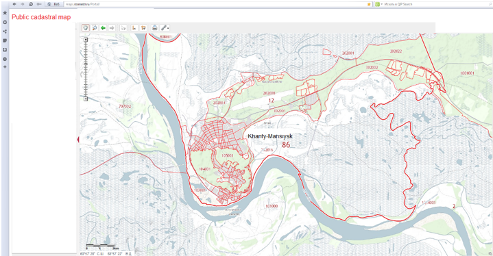
The area of works and pads of the Nizhne-Shapshinskoye field are located in the Khanty-Mansiysk District of the Khanty-Mansiysk Autonomous Okrug (hereinafter referred to as KhMAO-Ugra) and is presented in Figure 1 and Figure 2.
Fig. 1
Location of KhMAO - Yugra on the site of the geoinformation portal
of the spatial data infrastructure of the Russian Federation [4, 5]
-----
Fig. 2
Shrub sites at the Nizhne-Shapshinskoye field of KhMAO-Ugra
The geodetic survey of the boundaries of the deforestation contour for the development of the K-4 pad and the corridor of communications at the Nizhne-Shapshinskoye field and the receipt of a topographic plan were carried out on the basis of the contract agreement between OOO ZapSibGeoKom and JSC NAK AKI-OTYR at the construction sites of OAO "NAK AKI-OTYR", in accordance with the requirements of the terms of reference, licenses for the performance of the relevant work, the Customer's original data and in accordance with regulatory documents:
- SniP 11-02-96;
- SP 11-104-97;
- SniP 3.05.02-88;
- Instruction on the preparation of technical reports on geodetic, asynomic, gravimetric and topographical works ed. Moscow, Nedra 1971 [6-9].
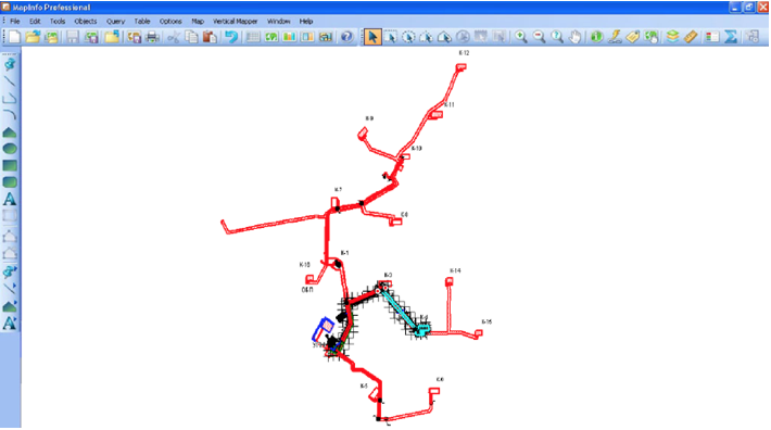
As a starting point, we used the customer's point - the Base, the point of the top of the barrier post, the planned altitude position of which was determined by the method of GNSS positioning (Figure 3).
Fig. 3
Location of the starting point – Base of the K-4 pad and communication corridor
The boundaries of the contour of the land plot for the arrangement of the K-4 pad and the communication corridor were determined by satellite technologies using a set of satellite dual-frequency GNSS receivers "Trimble R-7. GNSS Base "and" Trimble R7 GNSS Rover "by the kinematics method from the base station - Base with an error not exceeding the permissible values of the technical specification. At each fixed corner of the deforestation boundary, static GNSS determinations were carried out. The coordinates of the points are defined in the local coordinate system of the Customer in accordance with [10].
The boundaries of the contour of the land plot were fixed by the method of continuous felling of trees along the contour, with the marking of the corners of the turn of the borders by signing and tying with a signal tape to equip the K-4 pad and the communications corridor.
As a result of the work, a scheme of geodetic construction of the design and actual position of the boundary points of the contour of the land plot was drawn up according to the terms of reference, the acts were submitted to the delivery of the deforestation boundaries and the outlines of the fixed corners. The creation of the digital model of the object was carried out using the following software:
- Trimble Business Center;
- Microsoft Office Excel Formulas Editor;
- Text editor Microsoft Office Word;
- GIS MapInfo Professional.
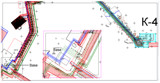
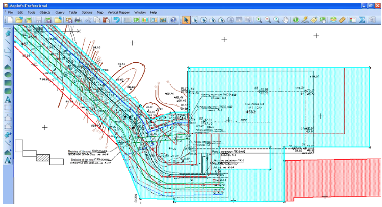
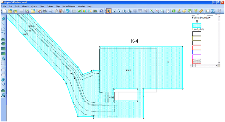
Figures 4 and 5 show the variants of digital models of the pad and the communication corridor in the functional windows of the MapInfo Professional 9.0 program with examples of results of engineering and geodetic surveys and the location of land plots and their cadastral numbers.
Fig. 4
GIS MapInfo – an example of results of engineering and geodetic survey at the site
-----
Fig. 5
GIS MapInfo – location of land plots and their cadastral numbers at the K-4 site
Based on the results of the performed measurements, the technical control of field and cameral work was carried out, with the colt it was established:
- compliance of the methodology used by the performer, the requirements of the instructions, conventional signs, instructions;
- adherence to the technical tolerances and requirements for the development of field technical documentation;
- condition of instruments, timeliness and completeness of their research.
The acceptance of the performed works by the customer was carried out with the preparation of acceptance certificates with the conclusion that engineering and geodetic survey of the boundaries of the deforestation contour were carried out in accordance with the current instructions, meet the conditions of the contract and are properly decorated.
The volume of the executed works has made 5,84 kilometers (table 1).
Table 1
The volume of the executed works
Type of work |
Measure |
Scope of contract |
Volume after the fact |
Defining the boundaries of the forest cutting contour |
kilometers |
4.00 |
5.84 |
It should be noted that modern GIS are effective in all areas where the accounting and management of the territory, including the fields and objects located on it, is carried out. These are practically all directions of the activity of the management bodies and administrations: transport, engineering communications, business development, emergency management, law enforcement and security, land and real estate management, demography, health care, ecology, etc. [11-14].
Scientists [15-19] estimated that most of the information (in different sources, values from 60% to 90% occur), which a person encounters in his life, has a territorial reference. Therefore, GIS can be used practically in any sphere of human labor activity.
Thus, we can draw the following conclusions:
1. The object of research is located on the land of industry and according to the town-planning legislation of the Russian Federation it is a cluster (industrial) site [19].
2. With the use of global navigation satellite systems, namely, a set of two-frequency GNSS receivers "Trimble R-7", the boundaries of the deforestation contour have been surveyed to equip the K-4 pad and the communication corridor at the Nizhne-Shapshinskoye KhMAD-Yugra field in the volume 5.0 km.
3. Cameral processing of the received results was carried out in Trimble® Business Center software and GIS MapInfo Professional 9.0.
4. The results of engineering and geodetic survey of the boundaries of the forest felling contour of the land plot for the construction of the K-4 pad and the communication corridor will be used to prepare documents, including those containing the necessary information for cadastral registration.
At all stages of the technology of engineering and geodetic survey, the example of the site and the corridor of communications at the Nizhne-Shapshinskoye deposit of KhMAO-Ugra offer its most appropriate methods and methods of using various modern technologies for obtaining spatial data and software for their processing, analysis and further modeling, in particular, for the formation of a land surveying plan and cadastral registration of land.
Thus, the approbation of the method carried out in the research is universal and can be used for development and development not only in the KhMAO-Ugra fields, but also in the territories of other deposits around the world.
Budarova V.A., Cherdantseva N.G. (2014) Results of economic evaluation of the project using an automated management system in the field of cadastral activity. Collection of materials of the XIII scientific conference of young scientists, graduate students and applicants of Tyumen State Mining University.-Tyumen: RIO TyumGASU.-259 p.
Regulations on the Federal Service for State Registration, Cadastre and Cartography of the Russian Federation [Electronic resource]: Decree of the Government of the Russian Federation No. 457 of 01.06.2009 (as amended on December 29, 2015) // Garant Legal System.
On Subsoil. [Electronic resource]: Federal Law No. 2395-1 of February 21, 1992 (as amended on September 30, 2017) // Legal system "Garant"
Medvedeva Yu.D., Budarova V.A. (2015) The use of geoportals to account for natural resources. Collection of materials of the international scientific-practical conference of the Tyumen State Architectural and Construction University. - In 2 tons - T. I. - Tyumen: RIO TyumGASU. - 252 p.
Public cadastral map on the portal of the Federal Service of State Registration, Cadastre and Cartography [Electronic resource]. - Access mode: http:// http://pkk5.rosreestr.ru/ (reference date: February 10, 2018)
SniP 11-02-96. Engineering surveys for construction. Basic Provisions
SP 11-104-97. Engineering and geodetic survey for construction
SniP 3.05.02-88. Gas supply
Instruction on the preparation of technical reports on geodetic, asynomic, gravimetric and topographical works ed. Moscow, Nedra 1971.
On the approval of the provision on the formation of local coordinate systems of municipal areas of the Tyumen region [Electronic resource]: Resolution of the Government of the Tyumen region dated 21.05.2008 № 138-n // Legal system "Garant"
The Land Code of the Russian Federation. [Electronic resource]: Federal Law No. 136-FZ of October 25, 2001 (as amended on May 23, 2016) // Legal system "Garant".
Bahaaldine, Azarmi. Scalable Big Data Architecture. A practitioners guide to choosing relevant Big Data architecture. – Apress, 2016. – 200 p.
Ronchi A. M. E-Culture. – New York: Springer–Verlag, LLC. – 2009. – p. 455.
Cartwright W., Peterson M. P., Gartner, G. Multimedia Cartography. – 2nd ed. – Berlin: Springer-Verlag, 2007. – p. 530.
Maiellaro N., Varasano A. One-Page Multimedia Interactive Map // ISPRS Int. J. GeoInf. – № 6 (2). – 2017. – P. 34–40.
Clarce К.C. Geographic information systems: definitions and prospects. — Bull. Geogr. and Map Div. Spec. Libr. Assoc., 1985. — № 142. - P. 12 —17.
Computer software for spatial data handling. International Geographical Union: Commission on Geographical Data Sensing and Processing. — Ottawa; Ontario, 1981. — Vol. 1: Full geographic information systems. — P. 136.
Grafarend, Erik W. Map Projections [Text] / Erik W. Grafarend, Friedrich W. Krumm // Cartographic Information Systems Springer, 2006. – 731 р.
Herrington, Jack D. Five XML dos and five don'ts that you need to know How to use XML the right way 07 December 2010. Available at: https://www.ibm.com/.
The Land Code of the Russian Federation. [Electronic resource]: Federal Law No. 136-FZ of October 25, 2001 (as amended on May 23, 2016) // Legal system "Garant".
1. Ph. D., Tyumen Industrial University, 625000, Russia, Tyumen, 38, Volodarskogo St.. e-mail: budarova@bk.ru
2. Leading geodesist of OOO ZapSibGeoKom, 625026, Russia, Tyumen, 52a, Odesskaya St.
3. Assistant, Tyumen Industrial University, 625000, Russia, Tyumen, 38, Volodarskogo St. e-mail: natali.cherdanceva@mail.ru
4. Postgraduate, Tyumen Industrial University, 625000, Russia, Tyumen, 38, Volodarskogo St. e-mail: yul.medwedewa2013@yandex.ru