![]() ISSN 0798 1015
ISSN 0798 1015

![]() ISSN 0798 1015
ISSN 0798 1015
Vol. 39 (Number 34) Year 2018 • Page 29
Marina LI 1; Orazkhan KARLYKHANOV 2; Dmitriy PONKRATYEV 3; Talgat IMANALIYEV 4 ;Tursunay TAZHIYEVA 5
Received: 16/03/2018 • Approved: 01/05/2018
ABSTRACT: In this article, we considered the application of modern IT technologies and management methods with automation of water metering on irrigation canals using the example of the developed water level sensor (DUV 2/0,005-10). The main criterion for evaluating the system and means for measuring the flow and volume of water is the reliability of the information obtained, which is determined by the reliability of the operation of the systems and the metrological characteristics of the measuring instruments. It is necessary to evaluate these characteristics in real operating conditions, since the high accuracy of the device indicated in the data sheet can significantly differ from the accuracy in operating conditions, as a result, the measurement error substantially increases. |
RESUMEN: En este artículo, consideramos la aplicación de tecnologías de TI modernas y métodos de gestión con la automatización de la medición del agua en canales de riego utilizando el ejemplo del sensor de nivel de agua desarrollado (DUV 2 / 0,005-10). El criterio principal para evaluar el sistema y los medios para medir el flujo y el volumen de agua es la confiabilidad de la información obtenida, que está determinada por la confiabilidad del funcionamiento de los sistemas y las características metrológicas de los instrumentos de medición. Es necesario evaluar estas características en condiciones reales de operación, ya que la alta precisión del dispositivo indicado en la hoja de datos puede diferir significativamente de la precisión en las condiciones de operación, como resultado, el error de medición aumenta sustancialmente. |

In the practice of water management in the Republic of Kazakhstan, water metering on canals is carried out with the help of gauging stations. Hydrometric stations are available at all water intakes of different kinds. In connection with the liquidation of large farms (collective farms and state farms) and the transfer of land to private ownership, the number of water users has risen sharply, and many canals and water metering stations have been abandoned, which, among other issues, has led to the problem of inefficient water management and decrease in the effectiveness of water metering on irrigation systems.
In this regard, effective planning of water distribution in such conditions requires the use of modern information technologies and management methods with process automation.
Measuring stations for measuring discharge are used on large canals, while on small canals the hydraulic method is mainly used. Water discharges passed through structures are determined by well-known hydraulics formulae (Butyrin, 1982). Water metering in farms is carried out by the least accurate and most labor-intensive methods with the help of graded structures, weirs, and water-measuring trays, and also by measuring results at other points of an inter-farm network. For example, only in Kyrgyzstan, there are about 6,000 gauging stations of different types in irrigation systems, of which 30% are weirs of all types, 2% are water-measuring attachments, 2% are Venturi trays and 15% are graded fixed stream beds (Kiselev, 1978). The correct placement of water measuring devices and their equipment at the main water intake points of irrigation systems is of the utmost importance (Kiselev, 1978).
Water metering on irrigation systems is the basis for conducting planned water use. The objectives of the irrigation water metering are as follows:
In a number of cases, situations that require the conversion of instrument readings to a form convenient for recording and processing information arise (Bochkarev, 2012). When performing these actions, the nature of the signal received from the sensor can be saved (for example, the signal can be amplified, sampled or modulated) or replaced (i.e., the signal received from the sensor is converted into a signal of a different nature by some single-valued law). These already secondary signals can, in turn, be converted (amplified, sampled or modulated) to transfer information to the desired distance without loss and distortion. The process of information processing during water metering at irrigation systems includes such technological operations as a recording of instrument readings on information carriers, processing of instrument readings, and issuing information about the received data. Registration of instrument readings is one of the main water metering operations, since without reliable registration of the received data; there can be no question of reaching the water-metering goal.
In modern irrigation systems, measured hydraulic parameters are very numerous. As a rule, check points or measurement points are located at hydrometric stations, pressure water pipelines of pumping stations, etc. Discharge and volume of water flow are subject to measurement. Other hydraulic parameters are measured as initial values for determining the above parameters. The use of automatic control systems for technological processes of water use makes a number of additional requirements for information support facilities. In particular, the operational control of water levels acquires special significance for assessing the dynamics of transient processes in the water supply networks of irrigation systems. Under these conditions, the analysis of the possibilities for measuring and monitoring basic hydraulic parameters is the basis for ensuring reliable water measurement. The domestic and foreign practice of using level detecting devices involves two basic methods of measuring levels (Filonchikov, 1997; Khamadov, & Butyrin, 1975).
The strategy of development of water metering at irrigation systems over the past decades has undergone a number of stages of development. So in the 40-60's the theory and practice of creating various types of hydrometric structures equipped with the simplest means of measurement were developed. In the 1970s and 1980s, instrumentation for water metering was improved on the basis of the principles of traditional hydrometry. This was the period of the most intensive work in the field of water metering. New measuring instruments based on ultrasonic, electromagnetic and other methods for monitoring the parameters of the water flow have been developed and experimentally tested. Automated regulators and flow stabilizers have been developed significantly. Conducting automation of technological processes created organizational and technical prerequisites for the creation of system water metering and its transformation into the information and advisory subsystem of water management (Bochkarev, Kovalenko, & Sergeyev, 1993; Bochkarev, 1987; Shevchenko, & Yatsiuk, 1983).
An analysis of the existing fleet of measuring instruments shows that a significant problem for today is the actual absence of measuring instruments for irrigation purposes fully meeting modern technical and metrological requirements (General industry guidelines for the development of computer-aided design systems, 1980; Egilsky, 1988).
Discharge as a defined hydraulic parameter is the derivative of the basic hydraulic parameters such as the level and flow rate in a water conduit. Seven basic methods for determining discharge are classified: hydrodynamic, tachometric, physical, marking, partial, concentration and correlation (Kovalchuk, & Prokopchuk, 1992). The implementation of any method assumes the obligatory presence of two technical components - a discharge converter and a device for measuring the flow rate. Discharge converters can be "fixed" sections of a stream bed or a closed water conduit, narrowing devices of various types and designs, special devices for the partial division of the flow into components, etc.
The current state of operational hydrometry and its metrological support can be characterized as critical. The existing instrument fleet was practically lost due to the moral and physical wearing-out of measuring instruments, their failure for various operational reasons, lack of maintenance, repair, and metrological verification. As a result, water management at irrigation systems is based on methods of measurement and control of the 30-40s using the available hydrometric facilities and the simplest means of measuring water level and velocity (General industry guidelines for the development of computer-aided design systems, 1980; Chou, 1969).
The significantly changed situation on the market of measuring instruments and equipment has a positive effect on the possibility to form irrigation system water metering.
Existing irrigation systems consist of standard structures (canals, interfacing, retaining and regulating structures, water outfalls, etc.) (Methods and means of water metering at irrigation sites, 1989). Operational experience shows that if the operating rules are observed, the design parameters of irrigation systems remain fairly stable (Bochkarev, & Ovcharov, 1981; Krasovsky, 1987; Natalchuk, Olgarenko, & Surin, 1995).
To measure the set water flow rates, many different designs of hydraulic automation equipment have been proposed. At present, with the creation of new farms on irrigated lands and the introduction of payment for water, the issue of metering the supplied water to farms, the supply of the set volume by means of automation, without recruitment of additional labor in the irrigation period, has become especially topical. In this regard, the direction of development and research was determined to improve water metering in irrigation systems.
The scientific novelty of the development of the water meter is the improvement of the system of automatic recording and control of the level and management of water resources for operational and balance water metering, information on water flow rates, the analysis of which allows to determine whether the main goal of water distribution has been achieved, whether the required amount of water is delivered on time.
Water measuring makes it possible to control the use of water resources and forms the basis for dispatching control of water distribution and water supply in irrigation systems.
According to the functional feature, the inter-farm part of an irrigation system consists of the main supply area, the command, and water distribution nodes, the points of water intake for farms; the on-farm network consists of nodes of on-farm water distribution, points of water intake for crop rotation areas.
The site of the main water supply at mechanical water intake includes a pumping station, a pressure pipeline, a stilling well and at gravity water intake it consists of the main water intake structure, the upper part of the main canal up to the main hydrometric station. In both cases, the main supply area includes a section of the river or reservoir with special devices (dams, anchorages, etc.) and a reference hydrometric station at the irrigation source to determine and measure water resources and the main hydrometric station in the head of the main canal to measure water intake into the system (Masumov, 2010).
An analysis of existing control devices of water level showed their limited use at the level of the irrigation system due to the complexity of operation or high cost.
As an example, we compare an ultrasonic liquid media level meter INNO Level ECHOIL-EC-A (Russia), «Siemens Sitrans Probe LU» (Germany) and the water level sensor DUV 2/0,005-10 (Kazakhstan) (Figure 1).
Figure 1
U
ltrasonic level sensors
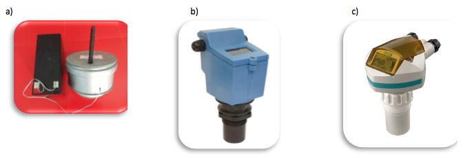
а) DUV 2/0,005-10 (Kazakhstan); b) ultrasonic liquid media level meter INNO Level ECHO IL-EC-A (Russia); c) «Siemens Sitrans Probe LU» (Germany)
The ultrasonic liquid media level meter INNO Level ECHO IL EC is an inexpensive ultrasonic level sensor for liquids with an analog current output or Modbus (RS 485) and 2 relay outputs (INNOLevel ECHO IL EC, n.d.; Ultrasonic level meter INNOLevel ECHO, n.d.; Ultrasonic liquid media level meter INNOLevel ECHO, 2011; Ultrasonic liquid media level meter INNOLevel ECHO, 2011).
The ultrasonic level sensor Siemens Probe LU is widely used to measure and control the volume of liquid and granular substances in the tank and the filling level of the tank (Ultrasonic level sensors Siemens Sitrans Probe LU, n.d.; Ultrasonic level sensors Siemens Sitrans Probe LU, 2005).
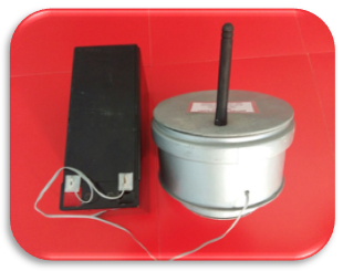
DUV 2/0,005-10 provides an operative, continuous water metering in canals. Its action is based on the use of the radar ultrasound method of measuring the water level, and on a principle of ultrasonic echolocation with correction of results and the use of the hydraulics formulae of open canals.
Figure 2
Water level sensor DUV 2/0,005-10
The review of modern technologies and general-purpose measuring instruments was designed to develop certain technical requirements and practical recommendations for their wide application on land development sites. Table 1 compares the characteristics of the water level sensors of different manufacturers.
Table 1
Comparative technical characteristics of water level sensors of different manufacturers
Designation |
Price, thousand tenges |
Manufacturer |
Measurement range, m |
Service life, years |
Automatic data transmission to the local network |
Calculation of rates |
Network and software diagnostics |
Energy consumption |
Water level sensor DUV 2/0,005-10 |
250,0 |
Kazakhstan |
5-10 |
10-15 |
Yes |
Yes |
Yes |
220 V/ accumulator 12 V/ solar panel |
Ultrasonic liquid media level meter INNOLevelECHOIL-EC-A |
287,0 |
Russia |
5-10 |
8-10 |
No |
No |
No |
220 V |
Level sensor Siemens sitrans Probe LU 7ML5221 |
485,0 |
Germany |
5-15 |
10-12 |
No |
No |
No |
220 V |
The prototype water level sensor developed in the Kazakh Scientific Research Institute of Water Management meets the requirements of modern automated systems and control devices of water resources, provides continuous water level recording at gauging stations.
The utility model refers to the control of water metering at hydraulic structures and can be used in irrigation systems.
The closest to the constructive solution and technical essence is the water level sensor based on ultrasonic measurement of the liquid level (Takara, Suzuki, Tsukuma, Maruno, & Okuyama, 2014).
The invention relates to the ultrasonic measurement of the liquid level and can be used to measure both the upper level and the interface of liquid media with different densities.
The method consists in measuring the levels of liquids by measuring the transit time of an acoustic ultrasonic pulse passing through a sound duct installed vertically inside the tank from the emitter to the receiver located at the upper end of the sound duct. The emitter is located inside the float, which is on the liquid surface and coaxially encloses the sound duct through which an alternating current flows, providing inductive power supply and synchronization. In this case, ultrasonic pulses are selectively excited by several piezoceramic emitters (a calibration element rigidly fixed at the lower end of the sound duct and measuring floats at the media interfaces) by temporarily separating the operation of the emitters in relation to the end of the AC supply via the sound duct.
The disadvantage of this prototype is the low reliability of work when receiving and processing source materials.
The water level sensor created in the Kazakh Scientific Research Institute takes into account the water level changes over a certain period of time, excludes unproductive water losses, transfers data automatically in a certain time of a day.
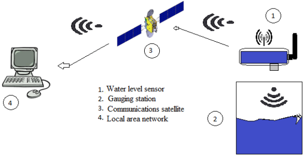
The goal is achieved by using an ultrasonic sensor that transmits sound waves into the water, and, reflected from the water, is transferred to the microcontroller. The microcontroller processes the data and transfers them to the information-transmitting module to a local network or in the form of SMS to a mobile phone. Cellular communication is practical as it can be used in all regions and in remote areas (taking into consideration the coverage area of the mobile network). The transfer of information is carried out via the mobile network in GPRS mode and allows receiving all information in real time. The frequency of obtaining information is determined programmatically by the operator's choice and ranges from a few minutes to a day (Figure 3).
Figure 3
Data transmission scheme
The automated water level sensor has the following technical parameters:
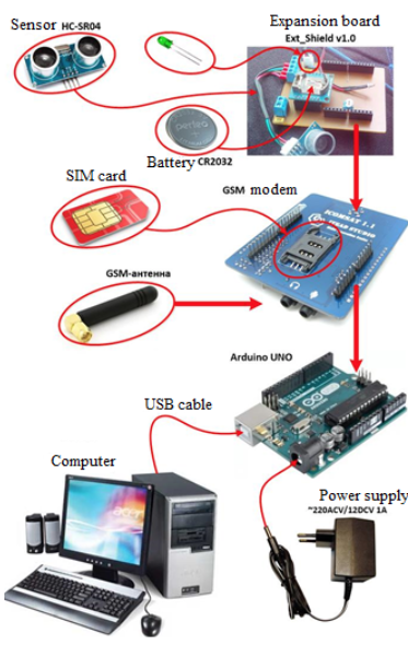
DUV 2/0,005-10 is an electronic device based on the Arduino controller, consisting of the following elements (Data sheet of the prototype of the technical means of water level control DUV 2/0,005-10, 2015):
The debug board ArduinoUNO is designed for development and prototyping various electronic devices (Figure 4).
а) debug board ArduinoUNO; b) ultrasonic distance sensor HC-SR04
Figure 4
Structural elements of DUV 2/0,005-10
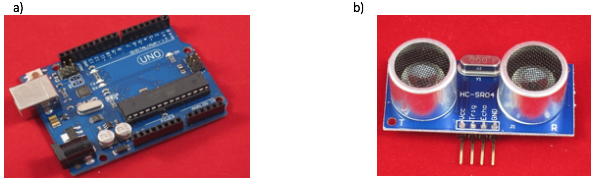
The brain of the board is the microcontroller ATmega328p with a clock frequency of 16 MHz. This small but powerful microcontroller manufactured by Atmel has an improved RISC architecture (RISC means reduced instruction set computer), which provides it with high performance - up to 16 million instructions per second (at 16 MHz clock frequency).
The ultrasonic distance sensor module HC-SR04 is designed for accurate distance measurement (Figure 4).
The principle of operation of this sensor is based on echolocation. There are two speakers on the sensor board. One of them works as an emitter and the other as a receiver (a microphone).
GSM-modem is intended for data transmission in GSM-standard networks (Figure 5).
Figure 5
Structural elements of the DUV 2/0,005-10
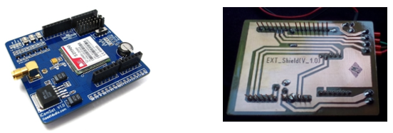
a) GSM-modem IComSat v1.1; b) printed board Ext_Shieldv1.0
With this modem, you can make phone calls, receive and send SMS messages, connect to GPRS over the Internet, and transfer data.
The expansion board is a small module that can easily connect to the Arduino board and perform additional functions that are not present in the Arduino main board (Figure 5).
The device DUV 2/0,005-10 operates in two modes: test and operational. In the test mode, the measurements are not triggered according to the schedule. The device DUV 2/0,005-10 is standing by to input the instructions from the serial port, and every 30 seconds there is a check of new SMS and new server instructions. In this mode, you can set DUV 2/0,005-10, see the saved settings, check whether the data is being sent, check the balance, etc. In the test mode, the GSM modem is constantly on, registered in the GSM network and connected to the Internet via GPRS.
The diagram of connecting DUV 2/0,005-10 to the computer is shown in figure 6.
Forecasting and metering is an important element of water resources management. This is due primarily to the transition of the Republic of Kazakhstan to a market economy. Therefore, more and more attention is paid to the use of modern software products such as universal statistical packages.
To implement DUV 2/0,005-10 the software that solves the problem of processing experimental water level data at hydrosystems has been developed. The software includes data processing, diagnostics of the data transmission system, data transmission modem configuration, data transmission error diagnostics, real-time request system, software diagnostics, software error diagnostics, sensor system diagnostics, charge control systems, adjustment of the ultrasonic water level sensor (Karlykhanov, Li, Bakbergenov, Zhakashov, & Imanaliyev, 2016).
To ensure the normal functioning of the software, a technology for automated control of water resources has been developed with the extension of functional actions and testing of the prototype of a water level sensor (Karlykhanov, Li, Bakbergenov, Imanaliyev, & Zhakashov, 2016).
Figure 6
Connection diagram of the sensor DUV 2/0,005-10 and a computer
A technical adjustment of the device for setting and managing the information about the operation of the device was carried out:
- implementation of the function determining the state of GPRS (Internet) connection;
- implementation of the function determining the level of GSM signal;
- implementation of the function determining the state of the communication with the server;
- implementation of the function displaying the IME code;
- implementation of the function displaying the current account balance;
- implementation of the function determining battery charge level.
The instructions from the server were processed to configure, manage and improve mechanisms for exchanging data between the sensor and the server:
- implementation of the function reading instructions from the server;
- implementation of the function sending the result of the command to the server.
Each command generates the response text and sends it to the source of the commands (in this case, to the server). To send a command response, you only need to know its ID.
The introduction of a spare data storage device in the form of micro SD flash card and the initialization of the device were carried out.
In addition, the sensor was registered on the server and automatically switched to the diagnostic mode.
The tests with the device carried out at the Asa hydrosystem, Teris-Ashchybulaq reservoir and on the Bazarbay canal of the Zhambyl region confirmed the operability of the device in real operating conditions.
During the scientific research, the water level sensor was installed in the South Kazakhstan region in the Maktaaral district on the K-19 canal and in its branches. In addition, the implementation took place at 3 gauging stations: Chon, Tesken and a direct-current machine in the Zhambyl region in the Merki district.
Water level measurements were made on all types of gauging stations using standard stream gauges of various lengths and an installed water level sensor DUV 2/0,005-10. All gauging stations are equipped with coastal stilling wells to exclude the influence of water fluctuations when taking readings from a stream gauge and the DUV 2/0,005-10.
Let us consider the carried out scientific and innovative works aimed at determining the accuracy of measurement of the water discharge with the device and without it on an example of the South Kazakhstan region.
In this case, we show the fragments of the results in the form of the dependency plots Q = f (H) for the canal K-19 and its branches (Figure 7).
Figure 7
Dependency plot Q = f (H) on the canal K-19 and its
branches according to the device DUV 2/0,005-10
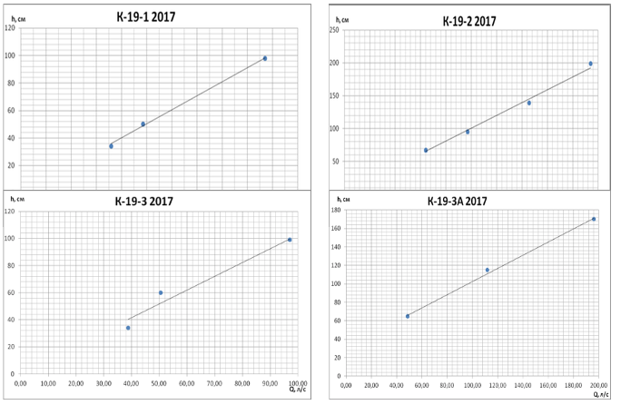
The main element of technical analysis is trend lines. They are used when building all graphic tools, as they help determine the current direction of movement of discharges. As can be seen from the plots (Figure 7), the scatter of points measured by the sensor is small, which indicates the accuracy of the measurements.
The results of statistical processing are presented in the form of compact tabular data, allowing to evaluate the reproducibility and correctness of the results obtained (Tables 2 and 3).
Table 2
Information about the water intake and water supply via the canal K-19 during
the vegetation period of 2017 for the Maktaaral district of the South Kazakhstan region
Months |
July |
August |
September |
Vegetation |
||||
Designation of a gauging station |
Average monthly discharge, l/s |
The volume of water per month, M m3 |
Average monthly discharge, l/s |
The volume of water per month, M m3 |
Average monthly discharge, l/s |
The volume of water per month, M m3 |
Total for vegetation, M m3 |
|
1 |
2 |
3 |
4 |
5 |
6 |
7 |
8 |
|
К-19-1 |
50,0 |
0,069 |
0,0 |
0,0 |
87,5 |
0,030 |
0,993 |
|
К-19-2 |
183,9 |
0,158 |
50,0 |
0,095 |
0 |
0 |
0,253 |
|
К-19-3 |
50,0 |
0,021 |
63,0 |
0,146 |
50,0 |
0,012 |
0,181 |
|
К-19-3А |
50,0 |
0,017 |
50,0 |
0,051 |
50,0 |
0,012 |
0,082 |
|
К-19-4 |
94,4 |
0,073 |
50,0 |
0,030 |
0,0 |
0 |
0,103 |
|
К-19-5 |
139,3 |
0,336 |
180,6 |
0,483 |
105,6 |
0,082 |
0,902 |
|
К-19-7 |
82,1 |
0,099 |
124,6 |
0,236 |
91,7 |
0,047 |
0,383 |
|
К-19-9 |
138,3 |
0,358 |
117,2 |
0,293 |
125,0 |
0,064 |
0,717 |
|
К-19-11 |
100,0 |
0,250 |
136,2 |
0,341 |
160,0 |
0,069 |
0,660 |
|
К-19-13 |
204,2 |
0,511 |
161,2 |
0,431 |
190,0 |
0,164 |
1,107 |
|
К-19-15 |
271,7 |
0,704 |
254,8 |
0,682 |
200,0 |
0,051 |
1,438 |
|
К-19-17 |
253,4 |
0,635 |
215,2 |
0,576 |
50,0 |
0,012 |
1,224 |
|
К-19-19 |
186,2 |
0,466 |
183,3 |
0,285 |
0,0 |
0 |
0,751 |
|
К-19-М-1-1 |
400,0 |
0,552 |
471,4 |
0,855 |
420,0 |
0,181 |
1,589 |
|
К-19-М-2 |
217,6 |
0,112 |
425,0 |
0,293 |
0,0 |
0 |
0,406 |
|
Total, m3 |
9,903 |
|||||||
-----
Table 3
The final indicators for water supply to consumers and water
intake via the canal K-19 during the vegetation period of 2017
Months |
July |
August |
September |
Vegetation |
Volume of water supply according to the sensor, M m3 |
4,368 |
4,804 |
0,730 |
9,903 |
The volume of water supply according to the information of the SOE "Kazvodkhoz" regarding the Maktaaral district, M m3 |
4,208 |
4,805 |
0,726 |
9,739 |
Deviation in water supply, M m3 |
0,16 |
0,001 |
0,004 |
0,164 |
The volume of water intake via the canal K-19 according to the sensor, M m3 |
4,543 |
4,996 |
0,759 |
10,299 |
The volume of water intake via the canal K-19 according to the information of the SOE "Kazvodkhoz" regarding the Maktaaral district, M m3 |
4,631 |
5,361 |
0,795 |
10,787 |
Deviation in water intake, M m3 |
0,088 |
0,365 |
0,036 |
0,488 |
As shown by the results given in the tables for the canal K-19 for the Maktaaral district of the South Kazakhstan region for the vegetation period:
Proceeding from this, it can be concluded that:
- the results of the work on the introduction of the water level sensor (DUV 2/0,005-10) in the pilot site, i.e. on the canal K-19 of the international "Dostyk" of the Maktaaral district of the South Kazakhstan region show the satisfactory convergence of the water flow measurement data of the compared options, which confirms the possibility of using the device in practice and allows the automation of the water metering in irrigation systems;
- the volume of water supply via on-farm canals for the vegetation period according to the sensor turned out to be 164 thousand m3 more than the volume of water according to the information provided by the SOE "Kazvodkhoz" regarding the Maktaaral district. This indicates that an important role in determining the volume of water is provided by the measurement of the water velocity with a rotor current meter. At low speeds, the rotations of the rotor blades result in a decrease in the true flow velocity;
- the volume of water intake via the canal K-19 for the vegetation period according to the sensor turned out to be 488 thousand m3 less than the volume of water according to the information provided by the SOE "Kazvodkhoz" regarding the Maktaaral district. In this case, it can be argued that losses of water (for evaporation, filtration and technological losses), according to the information provided by the SOE "Kazvodkhoz" regarding the Maktaaral district are overstated by 4.9%.
The water level sensor DUV 2/0,005-10 allows to have a wide range of technical means for measuring water levels on irrigation networks by creating a fairly simple utility model with acceptable cost and performance properties (Figure 2) (Karlykhanov, Li, Bakbergenov, Imanaliyev, & Zhakashov,2016; Karlykhanov, Li, Bakbergenov, Zhakashov, Imanaliyev, & Ponkratyev, 2017).
The main principle of the operation of the DUV 2/0,005-10 is the measurement of the water level in the automatic mode. Its operation is more adapted to sharply continental climate conditions, in comparison with foreign analogs, i.e. the device provides an accurate indication of the water level at temperatures up to + 55 and - 60°C, which is very important in a hot climate and with frequent winds in the southern region.
The introduction of the device DUV 2/0,005-10 at the gauging stations of the irrigation systems (using the example of two pilot sites) led to an increase in the accuracy of determining water level and flow rate and promptness in obtaining information in comparison with known methods. The use of this device in conditions of water shortage will ensure an objective water use metering on the one hand, and the development of lean consumption by water users, which will lead to an increase in the level of technological development of the agricultural industry and labor productivity. For example, compared to the widely used method of determining discharge with the help of a stream gauge and graduation curves "level-consumption", the accuracy of which varies from 1 cm and higher, and the efficiency of obtaining information is not foreseen, for DUV 2/0,005-10 the accuracy of detecting water level is 0.05 cm and the promptness in obtaining information is up to 1 s. This determines the innovativeness of the technical solution.
The authorship of the new solution is protected by a patent (Imanaliyev, Balgabayev, Karlykhanov, Li, Bakbergenov, & Tazhiyeva, 2016).
Bochkarev, Y. V., & Ovcharov, E. Y. (1981). Fundamentals of automation of technological processes in irrigation. Moscow: Kolos.
Bochkarev, Y.V. (1987). Operational hydrometry and automation of irrigation systems. Moscow: Agropromizdat.
Bochkarev, Y. V., Kovalenko, P. I., & Sergeyev, A. I. (1993). Fundamentals of automation of irrigation systems. Moscow: Kolos.
Bochkarev, V. Y. (2012). New technologies and measuring instruments, methods of water metering at irrigation systems. Moscow: Russian Scientific Research Institute of Land Development Problems.
Butyrin, M. V. (1982). Water measuring devices for hydrometric systems. Moscow.
Chou, V. T. (1969). Hydraulics of open canals. Moscow: Stroyizdat.
Data sheet of the prototype of the technical means of water level control DUV 2/0,005-10. (2015). Taraz.
Egilsky, I. S. (1988). Automated control systems for technological processes of water supply and distribution. Leningrad: Stroyizdat.
Filonchikov, A. V. (1997). Water metering technology at irrigation systems. Kostroma: KGSHA.
General industry guidelines for the development of computer-aided design systems. (1980). Moscow: Statistika.
Imanaliyev, T. K., Balgabayev, N. N., Karlykhanov, O. K., Li, M. A., Bakbergenov, N. N., & Tazhiyeva, T. C. (2016). Patent 1817 of the Republic of Kazakhstan, G 01 F 23/28, G 01 F 23/68, G 01 F 23/296 Water level sensor; applicant and patent holder Kazakh Scientific Research Institute of Water Management.
INNOLevel ECHO IL EC. (n.d.). In RusAutomation. Retrieved from https://rusautomation.ru/datchiki_urovnya/innolevel-echo
Karlykhanov, O. K., Li, M. A., Bakbergenov, N. N., Imanaliyev, T. K., & Zhakashov, A. M. (2016). Recommendations for the use of a water level sensor (DUV-2/0,005) at gauging stations with different sections of canals. Taraz.
Karlykhanov, O. K., Li, M. A., Bakbergenov, N. N., Zhakashov, A. M., & Imanaliyev, T. K. (2016). Software for processing experimental water level data at hydrosystems. Taraz.
Karlykhanov, O. K., Li, M. A., Bakbergenov, N. N., Imanaliyev, T. K., & Zhakashov, A. M. (2016). The technology of automated control of water resources with the extension of functional actions of the device DUV 2/0,005-10. Taraz.
Karlykhanov, O. K., Li, M. A., Bakbergenov, N. N., Zhakashov, A. M., Imanaliyev, T. K., & Ponkratyev, D. M. (2017). Recommendation on improving the system of automatic metering and control of the level and management of water resources in the south of Kazakhstan. Taraz.
Khamadov, I. B., & Butyrin, M. V. (1975). Operational hydrometry in irrigation. Moscow: Kolos.
Kiselev, N. G. (1978). Hydraulic reference book. Moscow.
Kovalchuk, Y. G., & Prokopchuk, A. P. (1992). Means of measuring water discharge and quantity of water at irrigation systems. Kiev: Khreshchatyk.
Krasovsky, M. Y. (1987). Perfection of methods and technical means of water distribution automation in open irrigation systems. Novocherkassk: NIMI.
Masumov, R. R. (2010). Recommendations for choosing type, location, and construction of water devices. Tashkent: Project report "IWRM-Fergana".
Methods and means of water metering at irrigation sites. (1989). Proceedings from All-Union Scientific and Technological Conference, Frunze.
Natalchuk, M. F., Olgarenko, V. I., & Surin, V. A. (1995). Operation of irrigation systems. Moscow: Kolos.
Shevchenko, A. V., & Yatsiuk, S. M. (1983). Substantiation of an indirect method of measuring the water supply by a pumping station into a closed irrigation network. Land development and water management, 58, 43-56.
Takara, T., Suzuki, H., Tsukuma, T., Maruno, E., & Okuyama, I. (2014). Patent 2523934 of the Russian Federation G 10 L 19/ 00 Transmitter; applicant and patent holder FIELD SYSTEM Inc. 2012145574/08.
Ultrasonic level sensors Siemens Sitrans Probe LU. (2005). Operating manual.
Ultrasonic liquid media level meter INNOLevel ECHO. (2011). User guide. Chelyabinsk.
Ultrasonic liquid media level meter INNOLevel ECHO. (2011). Data sheet. Chelyabinsk.
Ultrasonic level meter INNOLevel ECHO. (n.d.). In Promsitekh. Retrieved from https://www.prst.ru/innolevel/innolevel-echo/
Ultrasonic level sensors Siemens Sitrans Probe LU. (n.d.). In Sensoren. Retrieved from http://www.sensoren.ru/ultrazvukovie_datchiki_urovnya_siemens_sitrans_probe_lu.html
1. Candidate of technological sciences, Kazakh Scientific Research Institute of Water Management, Kazakhstan, Taraz, li_marina_taraz@mail.ru
2. Doctor of technological sciences, Kazakh Scientific Research Institute of Water Management, Kazakhstan, Taraz, orazkhantaraz@yandex.ru
3. Design engineer, Kazakh Scientific Research Institute of Water Management, Kazakhstan, Taraz, dmitr_ponkratyev@mail.ru
4. Junior researcher, Kazakh Scientific Research Institute of Water Management, Kazakhstan, Taraz, talgat.imanaliyev@mail.ru
5. Candidate of technological sciences, Taraz State University named after M.K.Dulaty, Kazakhstan, Taraz, tursunay.tazhiyeva@mail.ru