![]() ISSN 0798 1015
ISSN 0798 1015

![]() ISSN 0798 1015
ISSN 0798 1015
Vol. 39 (Nº36) Year 2018. Page 20
Orazkhan KARLYKHANOV 1; Marina LI 2; Aydos ZHAKASHOV 3; Tursunay TAZHIYEVA 4; Elmira MADALIYEVA 5
Received: 29/03/2018 • Approved: 10/05/2018
ABSTRACT: The article substantiates the condition of providing river ecosystems with a release for environmental protection purposes. The concept of "ecologically permissible level of river run-off use" has been introduced for this. Based on the flowchart for improving the methods of integrated water resources management, taking into account environmental requirements, the idea of creating a group of water bodies on the shrunking water area of former Aral Sea is proposed, which increases environmental sustainability in its Kazakhstan part. |
RESUMEN: El artículo corrobora la condición de proporcionar ecosistemas fluviales con un lanzamiento para fines de protección ambiental. El concepto de "nivel ecológico de uso de escurrimiento del río" se ha introducido para esto. Basado en el diagrama de flujo para mejorar los métodos de gestión integrada de recursos hídricos, teniendo en cuenta los requisitos ambientales, se propone la idea de crear un grupo de cuerpos de agua en el área de agua contraída del antiguo mar de Aral, lo que aumenta la sostenibilidad ambiental en su parte de Kazajstán. |

It is known that the water activity is a factor in the transformation of the natural environment, and river runoff is the environment-forming factor of the aquatic ecosystem. Economic use of river run-off beyond the established threshold will inevitably lead to its depletion and the disruption of the river regime formed by nature, of the equilibrium of floodplain and aquatic biotas.
Therefore, the concept of “ecologically permissible level of river run-off use” (hereinafter abbreviated as EPLRRU) has been introduced in the water management. EPLRRU in the Water Code of the Republic of Kazakhstan is the same as nature-friendly run-off, which, according to Burlibayev et al. (2007; 2014), is part of the natural run-off.
According to Burlibayev et al. (2007; 2014), the nature-friendly run-off consists of sanitary and epidemiological water discharge and release for environmental protection purposes. The sanitary water discharge is part of the natural run-off downstream of pollutant and waste water discharge sites according to the conditions of river ecosystems protection, and epidemiological water discharge is part of a controlled run-off, occurred in a certain period (for example, during a freshet) downstream of run-off control markers according to the conditions of river ecosystems protection (Burlibayev, 2007; Burlibayev, Faschevsky, Opp, Burlibayeva, Kaydarova & Vagapov, 2014). In the Republic of Kazakhstan, there are still no approved requirements for releases for environmental protection purposes and an approach to determining the maximum value of river run-off use.
In determining the sanitary water discharge during the Soviet period, the minimum daily average water discharge of a river was taken into account in the ordinary hydrological regime of summer and winter baseflows.
The purpose of the value of epidemiological water releases is even less justified, since a number of factors need to be taken into account here: the sanitary state of a water body, the productivity of ecosystems, recreational conditions, etc., which depends on a river regime, water quality characteristics and ecological requirements.
The conditions for providing river ecosystems with a release for environmental protection purposes in the modern water management system are more than enough, since in all river basins the river run-off is regulated by reservoirs depending on its magnitude - seasonal and long-term accumulation and use of water. The advantage of regulating a run-off with reservoirs is to reduce the risk of flooding in the high-water years and the risk of water scarcity in low-water years, as both cycles are harmful to a river ecosystem.
More recently, it has become more common to draw attention to the expediency of dividing a river run-off into two components: ecological and potentially free run-offs, which meets the contemporary challenges of the ecological requirements of river systems (Burlibayev, Faschevsky, Opp, Burlibayeva, Kaydarova & Vagapov, 2014). At the same time, "the ecological run-off is intended purely for the conservation of the river ecosystem by maintaining species biodiversity and reproduction of flora and fauna of water meadows and delta areas."
In addition to these basic functions, the ecological run-off should ensure the maintenance of the normative water, chemical, biological and temperature regimes, sediment run-off, hydraulic communication between surface and ground waters, recreation and soil flushing.
For the Aral Sea region, the use of river run-off with an ecosystem approach will provide water to the Kazakh part of the Aral Sea, natural and ecological complexes, including lake systems in the delta of the river.
Therefore, when using river run-off, the notion of "operational reception and rational distribution of spring freshet", is very important, and is, in fact, the main indicator of the well-being of a river ecosystem. As the experience of studying river ecosystems shows, these extreme situations, i.e. both long lasting flood during high water and the absence of flood events during low water lead to its disruption.
To justify ecological run-off value, it may be necessary to introduce into the practice of water management calculations a certain complex indicator that would be identical to the hydrograph of the river and variable in time, depending on the volume of water for an actual hydrological year in a long-term and intra-annual formation and distribution of a run-off. Ecological run-off can not be identified with sanitary runoff, as they have different functions: in the first case, it is a planned discharge of water downstream to ensure the environmental sustainability of a river basin, and in the second case it is a large-scale regardless of a volume of water for a year to maintain the environment in general and a river area in particular, in ecologically and epidemiologically safe state.
Given the increasing trend of reducing river run-off and water scarcity, it is time to form new approaches to solving the problem of the use and protection of water resources and the environment. Proceeding from this, a flowchart for improving the methods of integrated water resources management in relation to water management facilities in the Syr Darya River basin and the Aral Sea is proposed as a recommendation (Figure 1).
Figure 1
Flowchart for improving the methods of integrated water resources
management taking into account environmental requirements
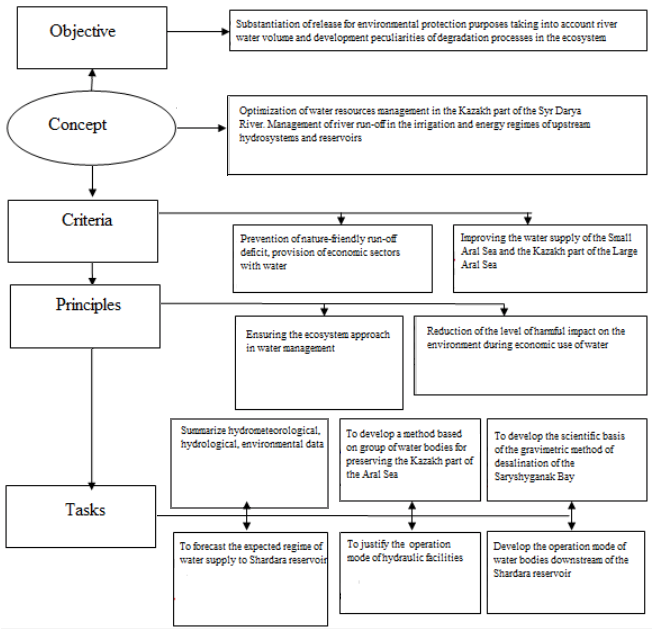
In the flowchart, one of the main indicators suggests modern environmental requirements for the further operation of existing water management systems. Requirements are also proposed for the creation of new water management facilities. The modern socio-economic and environmental situation in the Aral Sea area poses the task of developing both general principles of water resources management, their protection and reproduction, and quantitative methods for assessing the change in the hydrological regime, which allows to choose the best strategy for managing this regime.
Combining these two approaches seems most appropriate under the general title "ecosystem water use", the purpose of which is to manage water resources in a single technological process of their consumption and use, taking into account freshet safety and ecologizing the management of hydrological river regime.
From a scientific perspective, the management of freshet water and the use of its reserves for the water management system on the one hand, and for maintaining the river ecosystem on the other hand, should ensure freshet safety of the river basin and solve environmental problems in managing hydrological river regime. Therefore, the use of the term "ecosystem water use" will be more accurate instead of the term "planned water use" that is still in use.
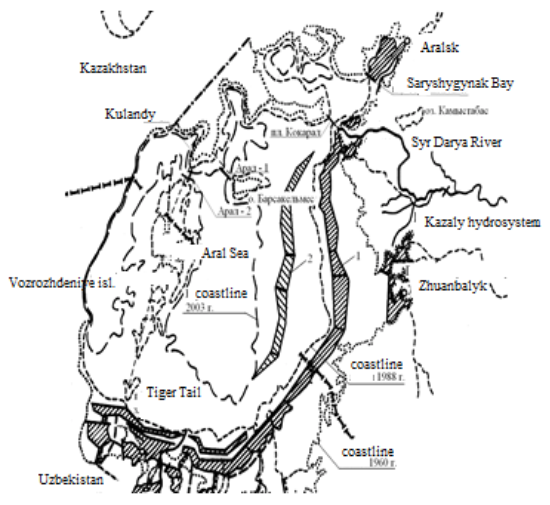
The Aral Sea, the second largest in Central Asia, until 1965, had a regime close to that historically formed 400-500 years ago. During this period, the sea level was stabilized at 52-53 mBS (Baltic system meters), water inflow into the sea was about 56-62 km3, and water mineralization was within 7-8 g/l.
At present, the level has been decreased by more than 18 m; the volume has been decreased by 75%, the water surface area has been decreased twofold. If in the years 1910-1960 annually an average of about 62 km3 of water flowed into the Aral Sea, then in 1961-1970 it was 43.3 km3, in 1971-1980 it was 16.7 km3, in 1981-1990 it was only 3.5 km3.
The run-off of the Syr Darya River did not reach the Aral Sea in 1974-1986. The run-off of the Amu Darya River did not reach the Aral Sea in 1982-1983, 1985-1986 and 1989, and since 2004, it has ceased to flow into the sea. The river bank retreated here and there more than 100-150 km back and now more than 40 thousand km2 of the sea surface are unwatered.
To save the sea in 1988, a competition for scientific development was announced, key scientific organizations, authors' collectives, individual scientists and specialists took an active part in it to find ways out of the crisis (Kotlyakov & Timoshchuk, 1991). The problem has evolved from a regional to an international scale (Miklin Filipp, 1990).
The proposed concepts offered different ways to save the sea. They fully addressed the water management, environmental, economic, socio-economic and medical-hygienic aspects of the problem. The following ways of supplying water to the sea were proposed:
1. Subsidy for the region due to the diversion of part of the run-off of the river waters of neighboring basins: the Siberian rivers or the Volga or the supply of water directly from the Caspian or Black Seas (NASA: The eastern part of the Aral Sea is completely dried up, n.d.).
2. The increase in the run-off of the Syr Darya and Amu Darya Rivers due to the artificial high-mountain glaciers melting or the one-off dewatering of high-mountain water bodies such as the Sarez Lake (Mirzayev, Rachinsky & Mukhamedzhanov, 1991).
3. The increase in the run-off of Central Asian rivers due to the transfer of groundwater resources. It is possible to include here the proposals for the discharge of drainage water by building sewers along the Amu Darya River (Khachaturyan & Aydarov, 1991).
4. Artificial increase in winter precipitation in mountains in order to restore the volumes and areas of mountain glaciation, and, consequently, the run-off forming potency of the mountain systems of the Pamirs and Tian Shan (Kotlyakov & Glazovsky, 1991).
5. Increase in inflow to the Aral Sea due to the use of internal reserves of the river basins of Central Asia (Kotlyakov & Glazovsky, 1991; Reshetkina, 1991).
In general, the aggregate of proposals for level stabilization and conservation of the sea was presented in the form of three main groups:
- water supply from external sources;
- artificial precipitation increase and climate change;
- use of internal reserves of river, ground and other waters.
But, as time showed, these efforts did not have a practical effect and it did not take off, as many of these projects turned out to be very expensive, others ineffective or insufficiently scientifically substantiated.
Currently, the sea is represented by three separate water bodies, two of which are salty and not suitable for fishery use.
Thanks to Dike Kokaral (built in 2005) the Small Aral Sea is revived, water surface increases, water salinity decreases, fish population is restored and the region revives economically.
At present, the Kazakh part of the Large Aral Sea is especially alarming, as here water management situation has got out of control (Altunin, Kupriyanova, Kharitonov & Khrapkova, 1990). The water surface level of the Large Aral Sea nearing the 30 mBS mark, its extensive eastern part is completely dry, which is a critical indicator, followed by a biologically dead zone with the complete disappearance of living things. This is the beginning of a new phase of environmental disaster with unacceptable indicators for all living things in the region (Karlykhanov, Balgerey & Ongarbayeva, 2014).
As it can be seen from the analysis, the problem of intensification of negative environmental impacts in the Aral Sea region problem passes to a new stage, which requires the adoption of urgent, scientifically sound decisions in the development of water management activities. One of them is the restoration of the water-salt regime of the northern Aral Sea using the gravimetric method of water desalination, which contributes to the improvement of the socio-ecological state of the region.
Approximately after the 1990s, measures were planned to consolidate sandy areas with the help of phytomeliorative measures and the creation of wetlands in the deltas of the Amu Darya and Syr Darya Rivers (Figure 2) (Karlikhanov, Ibatullin, Karlykhanov & Daldabayeva, 2016).
Figure 2
Proposed measures to stabilize the environmental situation in the Aral Sea region:
1 - phytomeliorative measures of the first stage, 2 - phytomeliorative measures of the second stage
Water desalination method of the Small Aral Sea
When mixing liquids having different densities, an intermediate separation layer is formed in which the density varies in height. The difference in densities between these liquids is due to the difference in their temperatures (temperature stratification), salt concentrations (chemical stratification), and concentrations of finely dispersed suspended particles (mechanical stratification).
In natural conditions, the temperature stratification is usually characterized by a small difference in the density in relation to flow depth, being less than one percent of the density of the medium, that of chemical stratification is several percent and that of mechanical stratification is characterized by values commensurate with the value of the density itself. Flow characteristics with the above features were applied to the water desalinization of the Saryshyganak Bay, which was called "gravimetric method" of flow desalination.
Researches carried out by German scientists on Lake Van showed the effectiveness of desalination method of separate parts of highly mineralized water bodies.
The Saryshyganak Bay, as a part of the Small Aral Sea, is now a dried up water body with an area of more than 800 km2 and is one of the centers of the emergence of dust-salt storms in the atmosphere. Therefore, researches related to the water-salt regime of the bay were conducted in the Small Aral Sea (Daldabayeva, 2004; Karlykhanov, 2002).
During the period of research (2003-2006), the water regime of the Small Aral Sea was characterized by instability due to sharp changes in the volume of inflow in the Syr Darya River (Table 1).
Table 1
Indicators of the Small Aral Sea during the period of research
Years |
Water inflow into the Aral sea region |
Small Aral Sea level, m |
Volume, km3 |
Area, km2 |
||
Total, km3 |
Small Aral Sea, km3 |
Large Aral Sea, км3 |
||||
2000 |
3,8 |
3,9 |
- |
40,23 |
21,59 |
2899 |
2001 |
3,5 |
3,3 |
0,3 |
40,32 |
21,86 |
2919 |
2002 |
8,6 |
9,2 |
- |
40,15 |
21,35 |
2882 |
2003 |
9,8 |
6,9 |
2,9 |
41,10 |
24,20 |
3091 |
2004 |
10,1 |
12,9 |
- |
38,16 |
21,38 |
2884 |
2005 |
9,9 |
5,6 |
4,3 |
40,42 |
22,16 |
2940 |
2006 |
6,8 |
2,3 |
4,5 |
41,51 |
25,43 |
3180 |
2007 |
6,6 |
3,0 |
3,6 |
41,78 |
26,33 |
3240 |
2008 |
3,7 |
2,0 |
1,2 |
41,46 |
25,28 |
3169 |
2009 |
4,1 |
3,3 |
3,8 |
41,76 |
26,27 |
3235 |
2010 |
9,2 |
5,1 |
4,1 |
42,15 |
27,35 |
3340 |
2011 |
4,6 |
3,5 |
1,2 |
41,59 |
25,82 |
3197 |
2012 |
4,6 |
2,0 |
2,6 |
41,80 |
25,70 |
3244 |
2013 |
4,1 |
2,4 |
1,7 |
41,78 |
24,43 |
3240 |
2014 |
4,3 |
1,9 |
2,5 |
42,15 |
24,75 |
3340 |
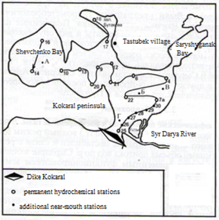
Researches in situ on the water-salt regime of the Small Aral Sea conducted in 2003-06 included the sampling of water in 4 points of the Small Aral Sea: the western, central, eastern and near-mouth parts of the sea (Figure 3).
Figure 3
The water intake points for chemical analyzes in the Small Aral Sea:
As a result of the data obtained, an action was developed to desalinate the eastern part of the lake using gravimetric method, which is different from existing methods is the application of the stratified flows property, i.e. its stratification while saturating with salts.
The salts of the lower layers eventually settle down and create an active salt concentrate for water-salt exchange within the entire water body. Periodically, by flushing the lower, most mineralized layers of the lake via adjustable bottom outlets, it is possible to achieve the desalination effect for water bodies in a short time (Figure 4).
Figure 4
The placement scheme of bottom outlets for flushing the lower layers of the water body
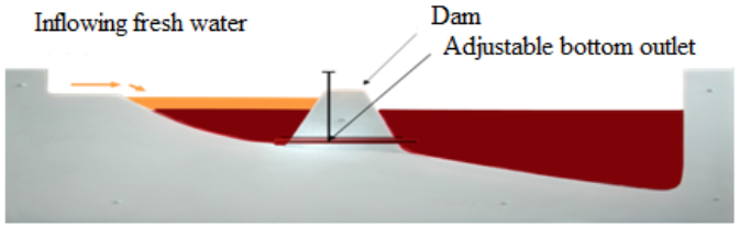
To achieve high-level water body flushing, it should be done with a maximum difference in the levels of the upper and lower pounds and with loosening the seabed using a minesweeper.
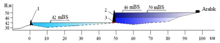
Restoration of the Saryshyganak Bay in the form of a freshwater body is a priority, as the main fishing town of Aralsk and other settlements turned out to be isolated among the sands retreatment of the sea. In this case, it is very important to establish the water level in the bay at a height of 50 mBS, as it was with the natural regime of the sea. In this case, ecological and social stability will be achieved in the Aral Sea region, water will reappear around the city of Aralsk and the sand advance will be suspended (Karlykhanov, 2008).
Thus, the Small Aral Sea will consist of two groups of water bodies: its central part with a level of 42 mBS and the Saryshyganak bay with a level of 50 mBS with a difference in water level in the groups of 8 m (Figure 5).
Figure 5
Creation of a two-level group of water bodies in the Small Aral Sea
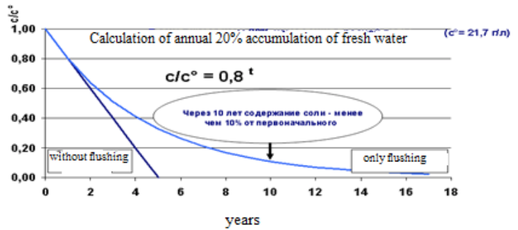
The principle of applying the properties of stratified flows is based on flushing only the lower salt-saturated layer. Salts of the lower layers settle with time and create active salt concentrate, increasing the mineralization of the water body during water-salt exchange. By periodically flushing the lower water layers via bottom outlets, it is possible to obtain a desalination effect for the bay in a short time (Figure 6).
Figure 6
Schematic diagram of salination of water bodies
Calculations found that the flushing rate of the lower layers depends on the difference in water levels in the group of water bodies. The displacement of the lower layer of water is much more effective when mixed with fresh water, after 6 years the volume of salt decreases by less than 10% of the original volume (Figure 7).
Figure 7
Duration of the water body desalination depending on the volume of fresh water supply
The water management calculation of water body filling for the Small Aral Sea and Saryshyganak Bay (Karlykhanov, 2010; Karlykhanov, Bekbayev & Tazhiyeva, 2014)
With the regulation of the Aral Sea region ecosystem, taking into account the limited water resources and the limit of releases for environmental protection purposes, the water management calculation for filling the groups of water bodies was based on a water volume equal to 5.85 km3/year, sea level of the Small Aral Sea of 42 m, and a water surface area of 3.17 km2 .
Table 2 gives the volume and the water surface area of the Small Aral Sea and the Saryshyganak Bay from the existing level of 42 m to 50 m.
Table 2
The volume, water surface area and evaporation volume
of the Small Aral Sea and the Saryshyganak Bay
Marks, mBS. |
Small Aral Sea |
Saryshyganak Bay |
||||
W, km3 |
F, thousand km2 |
W1, km3 |
W, km3 |
F, thousand km2 |
W1, km3 |
|
50 |
56,25 |
4,33 |
3,72 |
4,75 |
0,84 |
0,72 |
48 |
47,4 |
3,86 |
3,32 |
3,17 |
0,77 |
0,66 |
46 |
41,2 |
3,58 |
3,08 |
1,76 |
0,6 |
0,52 |
44 |
32,9 |
3,5 |
3,01 |
0,74 |
0,422 |
0,36 |
42 |
27,0 |
3,17 |
2,73 |
0,12 |
0,14 |
0,12 |
Note. Here W is the volume of the water body, F is the water surface area of the water bodies; W1 is the annual evaporation volume from the water surface.
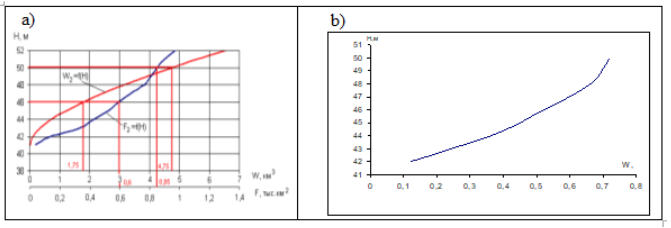
Calculations show (Figure 8) that the volume of the Small Aral Sea is 12-13 times larger than the volume of the Saryshyganak Bay at 50 m mark, and its area is 5 times larger. In order to raise the water level in the Small Aral Sea from the 42 m mark up to 50 m mark, the required water volume is at least 29 km3, and for the Saryshyganak Bay it is up to 4.5 km3. The additional water coverage in the Small Aral Sea is 4.33-3.17=1.16 km2 , the coverage area of the Saryshyganak Bay is 0.84 km2 . As can be seen, there is a big difference in the volume of water for raising the water level to the indicated marks.
Based on the static processing of full-scale data, the bathymetric characteristics and evaporation from the water surface were calculated. The topographic characteristics of the Saryshyganak Bay are shown in Figure 8, and those of the Small Aral Sea are shown in Figure 9.
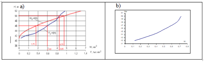
Figure 8
W means volume, F (a) means water surface area and W1 (b) means
evaporation from the water surface of the Saryshyganak Bay, km3
-----
Figure 9
The topographic characteristics (a) and evaporation
from the water surface (b) of the Small Aral Sea, km3
On the basis of water management calculations, the optimal water level of the Small Aral Sea with a 42 m mark and a water volume of 27 km3 is grounded. The water mark in the Saryshyganak Bay should be raised up to 50 m with a water volume of 4.75 m3. The implementation of this scheme makes it possible to increase the volume of water in these groups of water bodies up to 31.75 km3 with a coverage area of 4.01 km2 vs. 56.25 km3 and 5.17 km2 respectively with a “single-level” sea.
The time necessary to raise water marks up to the expected levels was calculated taking into account evaporation from the surface of the Small Aral Sea (Table 3).
It is clear from the calculation that it will take 16 years to fill the Small Aral Sea up to 50 m mark. At the same time, the water body filling will be uneven and depend on a volume of water of a particular year; during very low-water years (95% of the necessary resources and above), the flow into it may be less than an evaporation volume, which will lead to a decrease in the level in a particular year. At least 3 years are needed to fill the Saryshyganak Bay.
Table 3
Filling time for the Small Aral Sea necessary to reach expected marks
Marks |
Small Aral Sea |
||
ΔW=W1-W5, km3 |
ΔW1=W50%-W1, km3 |
Т = ΔW / ΔW1 |
|
50 |
29,25 |
1,776 |
16,47 |
48 |
20,7 |
2,176 |
9,51 |
46 |
14,2 |
2,416 |
5,88 |
44 |
5,9 |
2,486 |
2,37 |
42 |
0 |
2,766 |
|
Dust-salt storms are still common to the Aral Sea region. Such storms pump out into the atmosphere surface layer up to 85 million tons of poisonous impurities per year (Karlykhanov, Bekbayev & Tazhiyeva, 2014). The heart of this process is the dried-up bottom of the sea. It is a huge territory that makes up more than half of the former sea and causes anthropogenic change in the temperature regime: the winter got 1-2 degrees colder and the summer got 1-2 degrees hotter. The reason for the change in the temperature regime of the region is also clear. It is due to a decrease in the annual evaporation volume from the water surface, which impaired the climate-forming function of the sea.
The dynamics of the natural decline in water levels in the Kazakh part of the Large Aral Sea did not meet the forecasts of scientists and specialists. Despite the different water management measures, the level of the Large Aral Sea dipped by 25 m between 1975 and 2010 and its decline continues (Figure 10).
In these conditions, the main attention should be paid to reducing the volume of poisonous impurities pumped out into the atmosphere, i.e. to minimize the area of formation of a dust-salt storm with the introduction of various measures to protect the environment. For the Aral Sea region, taking into account the above, phytomeliorative measures are very important, which are currently being implemented. In areas where it is possible to transfer the drying part of the sea to wetlands, taking into account the releases for environmental protection purposes, we can get effective environmental and water management results (Karlykhanov, Balgerey & Ongarbayeva, 2014).
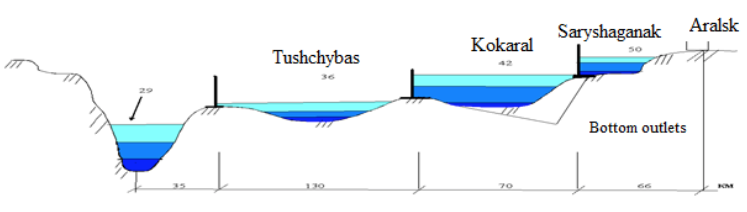
Figure 11 shows a schematic diagram depicting the regulation of water resources in the Kazakh part of the Large Aral Sea. The diagram shows the location of the dams to create the group of water bodies and wetlands and the approximate time frame for their construction.
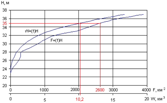
When creating wetlands at the 36 m level, about 3.2 thousand km2 will be covered with water (which is commensurate with the area of the Small Aral Sea) while the required water volume is 13 km3, which is 2 times less than the volume of the Small Aral Sea (Figure 12).
Figure 10
The forecast level marks of the water bodies of the Small Aral Sea and Kazakh
part of the Large Aral Sea: 1 – observed, 2 and 3 – levels according to optimistic
and pessimistic forecasts, 4 – the level of the Large Aral Sea after 1988,
5 – the level of the Kazakh part of the sea after 1995, 6 – the level of the existing
Small Aral Sea, 7 – predicted level of the first group of water bodies,
8 – predicted level of the third group of water bodies.
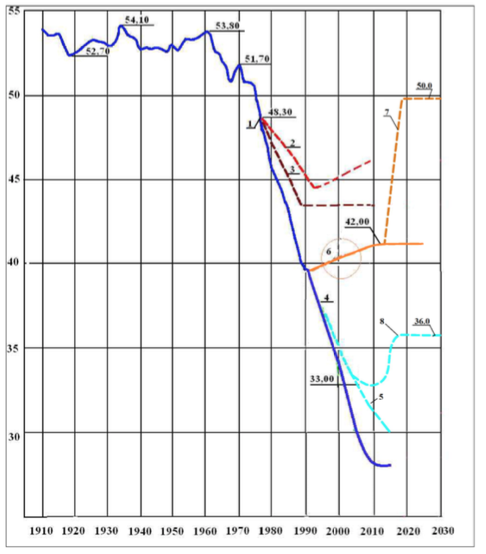
Figure 11. Principles of the regulation of the Aral Sea level with the help of group of water bodies: 1-5 – dams in the Saryshyganak Bay (1), Small Aral Sea (2) and in the Kazakh part of the Aral Sea (3 – between the Barsa-Kelmes island and the Kulandy peninsula, 4 – between the Vozrozhdeniye island and the Kulandy peninsula), 5 – between the Vozrozhdeniye island and the Tiger Tail peninsula in the Uzbek part of the Aral Sea
It should be noted that the wetlands in this part could be justified with lesser levels: 35, 34 etc., while the required volume of water decreases up to 5 km3. The hydrological characteristics of wetlands will be adapted to the water volume of the Syr Darya River.
Figure 12
Topographical characteristics of the Kazakh part of the Large Aral Sea
Creation of wetlands on the vast territory of the Kazakh part of the Large Aral Sea also contributes to the conservation of the Tushchybas Bay with more environmentally sustainable characteristics.
The creation of a group of water bodies in the Small Aral Sea and the Kazakh part of the Aral Sea with sea level marks ranging from 42 to 50 m will have the following positive effects:
1. The first group of water bodies creates parameters close to the natural water regime with 50 m level mark; the former water area of the Saryshyganak Bay will be filled and water will reach Aralsk and dried up berths, which is an important social factor.
2. With the help of the first group of water bodies the dried up part of the Saryshyganak Bay will be covered with water (the covering area is about 800-850 km2 , the volume is 4.75 km3), which is enough for the restoration and development of the fish industry; such species of fish as barbel, zander etc. will reappear here. The biodiversity of the bay will recover to its natural state.
3. Water and salt exchange will be provided between the Saryshyganak Bay and the Small Aral Sea, the process of water desalination in the bay will be transformed into a technological cycle.
4. In the Saryshyganak Bay area, the frequency of occurrence and power of emissions of harmful dust-salt storms will decrease.
The creation of wetlands in the Kazakh part of the Aral Sea with sea level marks ranging from 34 to 36 m will have the following positive effects:
1. A significant part of the dried up Large Aral Sea in its Kazakh territory is covered with water, which suppresses salt-dust emissions into the atmosphere, promotes the development of fishery and stabilizes the ecological situation in the region.
2. The group of water bodies optimizes the use of the Syr Darya River run-off in the lower reaches as a whole and of the nature-friendly run-offs in particular as well as the regulation of the water-salt regime of water bodies in the Aral Sea region.
Burlibayev, M. Z. (2007). Theoretical bases of the stability of the ecosystems of the trans-zonal rivers of Kazakhstan. Almaty: Kaganat.
Burlibayev, M. Z., Faschevsky, B. V., Opp, K., Burlibayeva, D. M., Kaydarova, R. K., & Vagapov, R. I. (2014). Scientific basis of rationing of the nature-friendly run-off of the rivers of Kazakhstan. Almaty: Kaganat.
Kotlyakov, V. M., & Timoshchuk, L. A. (1991). Competition "Aral" - All-Union brainstorm. Melioratsiya i ekologiya, 10, 7-13
Miklin Filipp, P. (1990). Drying of the Aral Sea: water management disaster. Melioratsiya i vodnoye khozyaystvo, 5, 16-9.
Miklin Filipp, P. (1990). Drying of the Aral Sea: water management disaster. Melioratsiya i vodnoye khozyaystvo, 6, 12-15.
NASA: The eastern part of the Aral Sea is completely dried up. (n.d.). In sdnnet.ru. Retrieved from http://sdnnet.ru/computers/
Mirzayev, S. S., Rachinsky, A. A., Mukhamedzhanov, M. V. (1991). Complex program of ecological transformations in the Aral Sea region. Melioratsiya i ekologiya, 4.
Khachaturyan, V. K., & Aydarov, I. P. (1991). The concept of improving the ecological and land development situation in the Aral Sea basin. Melioratsiya i ekologiya, 4.
Kotlyakov, V. M., & Glazovsky, N. F. (1991). The main provisions of the concept of the restoration of the Aral Sea and the normalization of the crisis situation in the Aral Sea region. Melioratsiya i ekologiya, 12, 10-14.
Reshetkina, N. M. (1991). The Aral Sea basin is a self-regulating natural system. Melioratsiya i ekologiya, 9, 10.
Altunin, V. S., Kupriyanova, E. I., Kharitonov, V. A., & Khrapkova, L. A. (1990). Assessment of the ecological and water management situation in Central Asia based on aerospace survey data. Gidrotekhnicheskoye stroitelstvo, 5, 37-40.
Karlykhanov, O. K., Balgerey, M. A., & Ongarbayeva, A. M. (2014). RSRNAS 2: Design Decision Estimation. Journal of Water Resource and Protection, 6.
Karlikhanov, T. K., Ibatullin, S. R., Karlykhanov, O. K., & Daldabayeva, G. T. (2016). Aral: the past, the present, the future. Astana: Forliant.
Daldabayeva, G. T. (2004). Perspective species of tree and shrub halophytes for placement on the dried bottom of the Aral Sea. Vestnik selskokhozyaystvennykh nauk Kazakhstana, 5, 24-26.
Karlykhanov, O. K. (2002). On the restoration of the Small Aral Sea. Gidrometeorologiya i ekologiya, 4, 111-115.
Karlykhanov, O. K. (2008). Hydroecological situation of the Large Aral Sea. Vodnoye khozyaystvo Kazakhstana, 3(19), 30-36.
Karlykhanov, O. K. (2010). Evaluation of project decisions of RRSSAM 2. Vodnoye khozyaystvo Kazakhstana, 2, 8 – 15.
Karlykhanov, O. K., Bekbayev, R. K., & Tazhiyeva, T. C. (2014). Issues of the restoration of the Small Aral Sea in Kazakhstan. World Applied Sciences Journal, 31(6), 1151-1154.
Karlykhanov, O. K., Bekbayev, R. K., & Tazhiyeva, T. C. (2014). Water Problems of the Aral Sea and Ways of Their Solution. World Applied Sciences Journal, 31(6), 1214-1216.
Tursunov, A. A. (2002). From the Aral Sea to Lop Nur. Hydroecology of the endorheic basins of Central Asia. Almaty.
1. Doctor of Technological Sciences, Kazakh Scientific Research Institute of Water Management, Kazakhstan, Taraz, Email: karlykhanov.orazkan@mail.ru
2. Candidate of Technological Sciences, Kazakh Scientific Research Institute of Water Management, Kazakhstan, Email: Taraz, li_marina_taraz@mail.ru
3. Junior Researcher, Kazakh Scientific Research Institute of Water Management, Kazakhstan, Taraz, Email: zhakashov.aydos@mail.ru
4. Candidate of Technological Sciences, Taraz State University named after M.K.Dulaty, Kazakhstan, Taraz, Email: tursunay.tazhiyeva@mail.ru
5. Doctor of Technological Sciences, Taraz State University named after M.K.Dulaty, Kazakhstan, Taraz, Email: madaliyeva.elmira.taraz@gmail.com