![]() ISSN 0798 1015
ISSN 0798 1015

![]() ISSN 0798 1015
ISSN 0798 1015
Vol. 40 (Number 16) Year 2019. Page 11
MEZENINA, Olga Borisovna 1
Received: 01/02/2019 • Approved: 09/04/2019 • Published 13/05/2019
ABSTRACT: The article considers the features of information support forestry land use, also considered the place of forest inventory and land management in the forest fund management system, as well as the main stages of the design of the forest area, it was concluded that the management tasks can be solved only on the basis of the system of information complex, including land management, forestry, cadaster and forest inventory, real estate cadaster, land monitoring and forests. |
RESUMO: O artigo considera que os recursos de suporte de informação florestal, uso do solo, também considerado o lugar do inventário florestal e de gestão da terra no fundo da floresta sistema de gestão, bem como as principais fases do projeto da área de floresta, concluiu-se que as tarefas de gerenciamento podem ser resolvidos apenas na base do sistema de informações complexas, incluindo a gestão da terra, silvicultura, cadastro e inventário florestal, imobiliário cadastro, a monitorização da terra e florestas, etc. |

One of the strategic goals of the country's development is the transformation of the Russian Federation into a dynamically developing power, therefore it is especially important to create information support for the country's economy in order to increase national wealth and improve the country's living standards.
The current system of forestry land use is not effective enough, doesn't meet modern requirements and doesn't contribute to the development of the state's ecological system. This is mainly due to the lack of timely and comprehensive information, which is the basis for managing land resources, including the forest fund.
The given task can be solved only at the complex decision of processes of land management and forest inventory of the lands of the forest fund.
The method of forest land use management is the information support of objective quantitative and qualitative accounting of forest lands, the formation of territorial planning and land management, the identification of reserves to improve the efficiency of use and management of the land and forest resources of the region and forestries, attraction investment and other extrabudgetary funds for the development of the forest complex and the territory as a whole, the implementation of land and forest policy.
Information support for forestry land use includes a system for collecting, processing and presenting information necessary for making management decisions on the use of forest fund lands at all administrative and territorial levels. The sources of information can be forest management, land management, a unified state register of real estate, monitoring of natural resources, land and forest control (supervision), protection of lands and forests, state cadastral valuation, etc.
The territorial organization of the lands of the forestry sector of the economy (FSE) is called upon to form, in accordance with the procedure established by law, the boundaries and land plots of administrative territorial units for management of forest lands (forest areas and forest parks) based on the developed land management and forest management design documentation. Land management and territorial planning are important tools in this area.
Land management documentation should include [1]: schemes for the land management of administrative districts and forest areas, land use schemes for districts and projects for territorial land management of municipal entities, projects for in-farm land management, working projects for individual activities (protection against erosion, roads, water supply, land improvement, etc.) and other developments.
The main purpose of the land use planning and design documentation is to ensure the interrelationships between the elements of the organization of forest territories and adjacent massifs of other categories of land fund (settlements, roads, agricultural land, etc.). The situation is complicated by the fact that there are significant differences in civil, land and forest legislation, which complicates the design work. For example, the main administrative-territorial unit of organization of forest fund lands are forest areas, the boundaries of which often do not coincide with the boundaries of administrative regions and municipalities established in land use schemes and territorial land management projects. Therefore, in the development of land management schemes and projects, decisions must be made on several areas, to conduct preparatory work, to collect information and develop projects and schemes over large areas, to coordinate development with 2-3 local administrations and a large number of different departments, which will lead to a significant increase in the cost of work.
Forest management works, according to the Forestry Code of the Russian Federation, include:
-projecting forest areas and forest parks (Figure 1);
-projecting of the massifs of operational forests, protective forests, reserve forests, as well as specially protected forest areas (Figure 2);
-projecting forest plots (Figure 3);
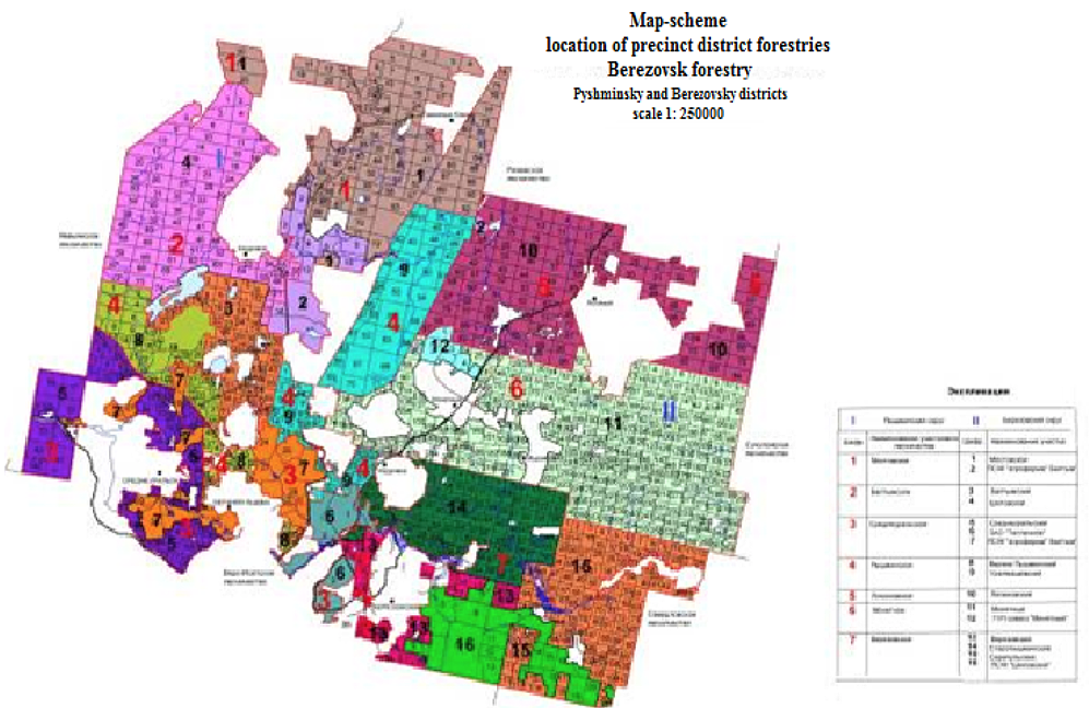
Fig. 1
Scheme design of district forestries in the
Berezovsky forest area of the Sverdlovsk region
- the strengthening of the boundaries of forest areas, forest parks, operational forests, protective forests, reserve forests, specially protected areas of forests and forest areas, and other activities related to land surveying, cadastral registration, registration of forest areas, forest parks and forest plots (figure 4).
This will require a large amount of information, especially for valuable sites (habitats of valuable species of flora and fauna, specially protected areas of forests, etc.);
- forest planning is one of the examples of innovative ecosystem technologies gradually introduced in various sectors of the national economy of our country for sustainable development of the regions. Other important tools in this area are land management and territorial planning. [2]
In fact, the forest plan is a set of economically justified organizational and spatial measures of the sustainable management of forest ecosystems at the scale of specific regions and territories, based on a quantitative analysis of the patterns of spatial heterogeneity of forests in the geographic information system. As with land management and territorial planning, the spatial-typological approach plays a leading role here [3]
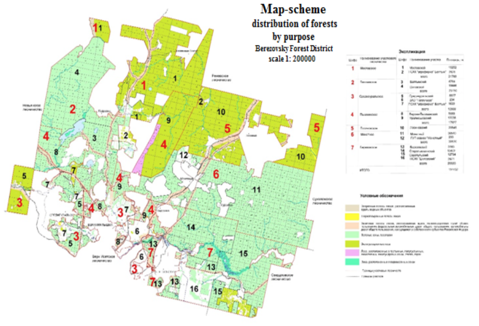
Fig. 2
Scheme of dividing the territory of the Berezovsky forestry of
the Sverdlovsk region into land plots by types of forest use [2]
-----
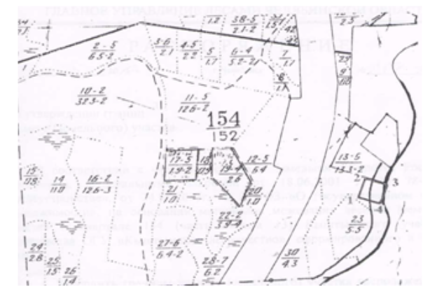
Fig. 3
Designing a forest plot for recreational purposes in
the Kyshtym Forestry of the Chelyabinsk Region [2]
-----
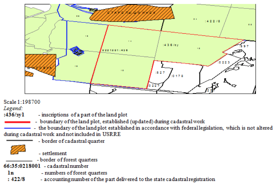
Fig. 4
The scheme of the land (forest) plot 66:35:0221001:436
(Sverdlovsk Region, Berezovsky District Forestry) [2]
It can be noted the need for land management, monitoring and cadastral activities, soil and geobotanical surveys, as well as data on soil classification and cadastral assessment, which allow to determine the qualitative and quantitative characteristics of land resources of FSE.
The information on forest fund lands and forests, in accordance with the implementation of the RF legislation, is based on data of state cadastral registration and registration of rights to forest plots, monitoring of land and forests, land cadastres, real estate cadastres, subsoil cadastres, etc.
In accordance with the provisions of the Forestry Code of the Russian Federation, forest areas are the main territorial units of forest recourses management. Forestry should be the organizer of bidding in the auction [4], engage in state control, organize forest inventory, maintain the state forest registry, maintain industry statistical reporting and ensure the implementation of the forestry regulations.
The agency of the Federal Service for State Registration, Cadastre and Cartography (Rosreestr) and organizations subordinate to them must ensure the maintenance of a unified state register of real estate (USRRE), state monitoring of lands and land management on federal property lands, including lands of the forest fund, on the basis of the data of the boundary plans [5]
The main features of the project land management documentation in the field of land use FSE can include the placement of the following elements of the organization of the territory [with considering 6]:
- determination of the number of forest areas and precincts of forestries, placing their borders;
- Establishment of the number and formation of forest parks boundaries;
- zoning of forest areas and forest parks;
- delineation of forests for their intended purpose;
- placement of other objects of economic activity of the forest complex (collection and primary processing of wood and non-timber forest products, recreation, hunting, etc.);
- location of main highway network;
- transfer (transformation) of land from one category of land to another;
- formation and justification of security, sanitary protection zones, etc.
All above-mentioned elements of land-use planning should be taken into account when drawing up forestry map-schemes, for example, as in Figure 5.
To control over forest lands, it is necessary to develop and implement in practice forestry and land management zoning of the territory of the subject of the Russian Federation, which should precede the stage of designing forest plots on the basis of analytical information.
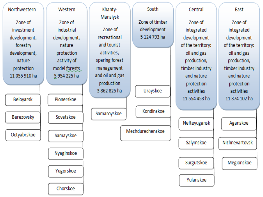
For example, in Khanty-Mansi Autonomous Area, six economic zones can be identified according to forestry conditions, to which a differentiated approach will be applied in the Forest Plan of the region for the analysis and planning of forestry land use (Figure 6).
Analyzing scientific materials and legislative acts, it was revealed that forest-economic and land use zoning suggests an estimated differentiation of forest resources of RF subjects by the following factors [1, 7, 8]:
Fig. 5
Fragment of designing the territory of the Berezovsky forestry
in accordance with the forest management regulations [2]
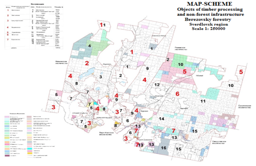
Fig. 6
Scheme of the Khanty-Mansi Autonomous Areaterritory breakdown
into forest-economic zones in the forestry section [2]
- Valuation and rent-forming indicators of lands and forests and conditions of their operation. Depending on the forest economic zoning, the rates of forest taxes should be differentiated and structurally linked to the minimum rates of payment for timber. This is achieved by calculating the coefficients that set the ratio: β = r / rmin (with the condition β ≥1,0), where: r - average rate of forest taxes; rmin - the average minimum rate of payment for timber;
- the availability of public transport routes that determine the transport availability of resources relative to the domestic and export markets for the marketing of forest products;
- availability of production capacities for timber harvesting and processing;
- Presence in the forest fund of specially protected areas, their protection and sanitary protection zones.
When developing analytical information on this range of issues, it is necessary that indicators of the use and reproduction of forest resources be collected and used for each forestry area simultaneously in land and forest management developments.
For the preparation of the project, the following information on the natural and economic conditions of the land management and forest management works is need to be collected [with considering 9, 10]:
- the location of the object of design in a certain area and the spatial location of forests in the administrative district in question; wooded area of the administrative district in the zone of forestry;
- the availability of forest lands unsuitable for growing forests and lands, which are possible for use in agricultural production with the exception of the forest fund;
-The presence of eroded and degraded lands in the zone of activity of the leshoz, planned measures for them on forest reclamation;
-characteristics of the ecological situation in the objects of forest inventory; determination of the factors affecting it, sources of pollution of the natural environment and other harmful effects;
- plots of forest plots leased with information on tenants and types of forest use;
-transport infrastructure - public roads, timber transport, forestry and fire prevention; with an indication of the length of roads per 10 thousand hectares of the total area of the forest inventory object when compared with the normative extension.
In addition, during the preparatory work, the following documents and materials should be collected, analyzed and prepared [using 1, 2, 11]:
-Materials of the last forest management and land management;
-Providing and eligibility documents for real estate and land plots, confirming the right to use land plots, documents of reference nature;
- information about cadastral division of the territory within which land (forest) plots are located, definition of numbers of cadastral quarters within the boundaries of which the corresponding land (forest) plots are located. In paper and in electronic form;
- Information about land plots that have passed state cadastral registration;
- Information about adjacent land plots, designated use and their permitted use;
- Information about the state cadastre of real estate on the boundaries of the lands of settlements, the approved boundaries of administrative regions, the boundaries of municipalities;
-projects of redistribution of agricultural land, stored in the state fund of land management data.
- Information about owners, tenants and other land users of land plots adjacent to the boundaries of the land (forest) plot (these data are necessary for borders reconciliation);
-The availability of engineering communications and encumbrances, according to data received in the relevant organizations.
Based on the preparatory materials, a consolidated project for the organization and development of forestry in forests located on the territory of the subject of the Federation is being prepared, maps of forests are being compiled, an information base for forest monitoring is being created, etc.
Development of forest management projects should be carried out in conjunction with land management, land use and cadastre work, conducted according to the relevant technological schemes.
USRRE is a collection of reliable, systematized information on immovable property registered in accordance with this Federal Law, registered rights to such immovable property, the grounds for their occurrence, rightholders (clause 2, Article 1 of the Federal Law №218) [5] State information resources are resources that are owned by the state as an element of property and are formed in accordance with the spheres of reference (Federal Law "On Information, Information Technologies and Information Protection" of July 27, 2006 N 149-FL).
Based on the information of the state real estate cadastre, the bodies that register and register spatial objects (property, natural resources, territorial zones) coordinate their activities in terms of information and technological interaction. Thus, a unified information space is formed about the land and related objects.
Through the information function, citizens, the business community, government authorities and management are provided with reliable and legally relevant information about real estate objects. The registry acts as a source of information of official state information that is not subject to re-confirmation by other bodies.
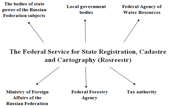
The interaction between the system of the state cadastre of real estate and other information resources is reflected in the Federal Law No. 218-FL of July 13, 2015 "On State Registration of Real Estate" (as amended and supplemented, effective from 01.02.2018, Article 34) [5] (figure 7).
Fig. 7
USRRE interaction with other information resources [5]
The author's analysis of some forest management and land management works in the forest districts of the Sverdlovsk region showed the need for mandatory mapping of the following aspects:
-clarification of cadastral division, both within the boundaries of the subject of the Federation and within the administrative area, taking into account forest management materials based on more relevant cosmo- and aerial photographs, and also using topographic maps of large scale;
-defining the boundaries of settlements;
- Refinement of the boundaries of adjacent land plots previously placed on cadastral records with new land (forest) plots;
- correction of the cadastral card on duty.
Analysis of ongoing work and placed elements of the organization of the forest area showed a close relationship between land management, cadastral, monitoring and forest management design and production activities. From 43% to 100%, the same information on the above activities is used in the development of land management and forest management documentation or appropriate actions with forest sites (survey, harmonization, registration, etc.). Therefore, in order to reduce the cost of design work, to shorten the terms of their implementation, and to agree on the development of project elements, it is advisable to carry out land-use and forest management project works simultaneously. The analysis showed that the savings in financial resources and time at the same time is 20-40%. If we take as a basis for calculations the average weighted cost of cadastral and monitoring works equal to 1.0 thousand rubles / ha, and forest management works - 0.2 thousand rubles / ha, then from 1 ha of forest area due to the combination of design works, we get 480 rubles of savings [2]
It is worth highlighting the following proposals for improving the efficiency of cadastral work on the lands of the forest fund, keeping records of land plots of forest fund lands within the boundaries of the RF subjects forestries:
- provide to the departments an algorithm of actions when using data on the imposition of boundaries of forest fund plots on land of other categories;
- to make information on the boundaries of the forest fund in the USRRE and not allow the placement of land plots for cadastral registration in case of imposing on forests;
- to provide for the digitization of forest management plans and the creation of a digital basis in coordinate systems, including for the purposes of entering into USRRE data, as mandatory preparatory measures for forest management;
- to consider the issue of optimizing the works on the setting of forests on the cadastre, taking into account the objectives of the subsequent granting for use;
- carry out systematic inter-agency information exchange between the State Forest Registry and the USRRE.
We agree with the conclusions of many specialists and scientists in the field of land management and cadastres that the availability in the real estate cadastre of an information layer created on the basis of state registration of forest fund lands as of the date of the last forest inventory will make the procedure for coordinating the boundaries of adjacent land use with state authorities responsible for the preservation of forests, as well as allow to quickly resolve issues related to the preparation of documents on the transfer of land from one category of land in another. The location of the boundaries will be constantly refined by more accurate data obtained by performing cadastral work. Correctly established in nature and on the plan, the boundary of the forest area serves as the basis for an accurate determination of its area.
The maintenance of the real estate cadastre at the level of the federal information system excludes the possibility of double counting of real estate objects, provides more complete control over the activities of cadastral registration bodies, simplifies procedures for inter-agency information exchange and processing of extraterritorial requests for information on cadastral records regardless of their location.
So, one of the most important tasks for the development of forestry land use today is an organizational and management task that can be solved only on the basis of a system information complex (land management, forest cadastre and forest inventory, real estate cadastre, land monitoring and forest monitoring, etc.). This task can be solved only with the integrated solution of the land management and forest management processes in the forest sector of the economy.
[1] Bondarchuk, A.S. Efficiency of land use under protective forests (on the materials of the North-Caucasian Federal District) [Text]: diss. cand. econ. science / A.S. Bondarchuk- M., 2011.
[2] Mezenina, О.B. Forming an effective system of land resources management in the forestry complex of the Russian Federation (theory, methodology, practice): diss. econ. sciences 08.00.05 / Mezenina Olga Borisovna; [a protection Place: GOS. University of land management] -383 S.
[3] On the approval of the provision on the preparation of the forest plan of the subject of the Russian Federation: Government Decree Ros. Federation of 24 April. 2007 № 246 // Collected. legislation of the Russian Federation.-2007.-30 Apr. - (item 2235). - Appendix: Regulations on the preparation of the forest plan of the subject of the Russian Federation.
[4] On approval of the Methodology for determining the initial price of the subject of the auction for the right to conclude a lease agreement for the forest plot and calculation of contract prices for the implementation of measures for the protection, protection and reproduction of forests: a decree of the Government of the Nizhny Novgorod region. [August 18, 2009. № 611] - Appendix: Methodology for determining the initial price of the subject of the auction for the right to conclude a lease agreement for the forest plot and calculation of contract prices for the implementation of measures for the protection, protection and reproduction of forests.
[5] Federal Law "On State Registration of Real Estate" of 13.07.2015 N 218-FZ (last version) [Electronic resource] // Consultant plus http://www.consultant.ru
[6] Gagarin, Y.N. Institutional environment for leasing forest areas / Y.N. Gagarin, T.V. Mochaeva // Regional economy: theory and practice. - 2008. - №. 26 (83). - P. 24-28.
[7] Mochaeva Т.V. Chernyakevich L.M. METHODOLOGICAL BASES FOR SUSTAINABLE FOREST MANAGEMENT MONITORING. Chernyakevich L.M., Andrianov Y.S., Mochaeva T.V. Journal of Applied Engineering Science. 2016. T. 14. № 2. P. 306-313.
[8] Bolshakov N. M., Zhideleva V. V., Ivanitskaya I.I. Multifunctionality of forestry as a basis for creating an aggregate innovative forestry product // Economy of the region. 2013. № 2 (34). P. 133-145.
[9] Silin Y.P., Animitsa E.G., Mezenina О.B. Ural - XXI century: the region of advanced development. / Y.P. Silin, E.G. Animitsa, О.B. Mezenina et al. / Monograph. - No. Arr. and Science of the Russian Federation, Ural. State. econom. Univ. Ekaterinburg, 2016.-202 p.
[10] Tatarkin A.I. Regional orientation of the economic policy of the Russian Federation as an institution for spatial development of territories // The Economy of the Region. 2016. Vol. 12. Issue. 1. P. 9-27.
[11] The rationale for the development of resource territories is the complex "meso-level" problem / V.A. Kryukov, A.E. Sevastyanova, A.N. Tokarev, V.V. Shmat // Economy of the region. 2015. № 4. Pp. 260-274.
[12] Fisher, C., Lauria, E., Chengalur-Smith, S. & Wang, R. (2011). Introduction to Information Quality. Bloomington IN: AuthorHouse.
[13] Floridi, L. (2011). The philosophy of information. Oxford [England] New York: Oxford University Press.
[14] Forest plan of Tula region [Electronic resource] // http://docs.cntd.ru/document/424067420
[15] Sozinova A., Kataeva N. Prioridades de uso de nuevas Tecnologías de Información y Comunicación en la economía moderna. Magazine ESPACIOS.
Vol. 39 ,Year 2018, Number 286. Источник: http://www.revistaespacios.com/a18v39n28/18392810.html
1. Doctor of Economic Sciences, Head of a Chair «Land management and cadastres», The Ural State Timber University (37, Sibirskiy trakt st., Ekaterinburg, Russian Federation, e-mail: mob.61@mail.ru