![]() ISSN 0798 1015
ISSN 0798 1015

![]() ISSN 0798 1015
ISSN 0798 1015
Vol. 40 (Number 20) Year 2019. Page 19
SIMAKOVA, Tamara V. 1; SIMAKOV, Anton V. 2; SKIPIN, Leonid N. 3; CHERNYKH, Elena G. 4 & STAROVOITOVA Ekaterina S. 5
Received: 18/03/2019 • Approved: 05/06/2019 • Published 17/06/2019
ABSTRACT: In the article the technique on the basis of the mechanism of functioning of municipal areas, the analysis of the maintenance and methodical bases of development of schemes of territorial planning and land management. In the course of research is used landscape-ecological approach, the correlation analysis of statistical data. On the basis of the carried out researches conclusions are made, recommendations aimed at the rational use of land resources and the formation of sustainable land use are developed. |
RESUMEN: En el artículo la técnica sobre la base del mecanismo de funcionamiento de las áreas municipales, el análisis del mantenimiento y las bases metódicas de desarrollo de Lou de la planificación territorial y la gestión de la tierra. En el curso de la investigación se utiliza el paisaje-enfoque ecológico, el análisis de correlación de datos estadísticos. Sobre la base de las conclusiones de las investigaciones llevadas a cabo, se formulan recomendaciones para el uso racional de los recursos de la tierra y la formación de un uso sostenible de la tierra. |

The relevance of monitoring is due to changes in the state of all land, especially agricultural land. The influence of negative processes adversely affects the economic value of agricultural land. The absence of monitoring surveys, analysis of trends and forecasting of negative processes can lead to the fact that negative changes in natural complexes will become irreversible. The growth of disintegration, degradation of agroecosystems and their components, including soils predetermines the ecological crisis (Pashnina, Simakova, 2017; Simakova, Skipin, 2015; Simakova, Podkovyrova, Oleynik, 2015).
One of the determining conditions for stable political, social and economic development of the territory is the creation and practical implementation of an integrated system of state management of civil turnover of land resources, which includes land technologically or functionally firmly connected with it real estate objects (buildings, structures, etc.), subsoil, forest Fund and water-covered areas (Skipin, Petuhova, Romanenko, 2017; Gaevaya, Skipin, Zakharova, Bogaychuk, Tarasova 2017; Podkovyrova, Oleynik, Matveeva, 2018).
The main place in the system of land management is occupied by land management, real estate cadastre and land monitoring. Since, through the land management system should be carried out the main functions of land management: planning, zoning, organization of rational use and protection of land. At the same time, land management and land control are carried out on the basis of information support of the real estate cadastre and land monitoring (Shakhova, Sannikova, 2016; Maslov, Simakova, 2018; Yurlova, 2017).
The relevance of the work. Land resources are a priority among others, as the most important task of each country is to provide people with food. In connection with the long-term restoration of land resources, each state is working with the problem of rational and efficient use. Rational use depends primarily on how well organized the use of land.
The aim of the work is to conduct a comprehensive analysis of land use and develop recommendations aimed at the formation of a sustainable land use system.
The object of the study are the land resources of Tyumen region (agricultural land).
The formation of the land and property complex is based on the organization of cadastral and geodetic works, the result of which are properly formed real estate.
As a result of cadastral works the land plot and parts of the land plot are formed. Cadastral registration confirms the existence of a land plot with its inherent properties and characteristics, representing the ability to define it as an individual-a certain thing.
Based on the data of land monitoring and landscape-ecological zoning cluster analysis is provided.
The task of cluster analysis is reduced to the presentation of primary information in a compressed form without its loss. Its essence is reduced to the unification (classification) of objects non-sequentially for the individual features, and simultaneously with a large number of features (Simakova, Skipin, Evtushkova, Simakov, Pashnina, Matveeva, Yurlova , 2018; Starovoytova, Simakova, 2017).
Quantitative evaluation of the close relationship between two random variables is carried out using the correlation coefficient. The type of correlation coefficient and, consequently, the algorithm of its calculation depend on the scale in which the studied parameters are measured and on the form of dependence. The correlation coefficient reflects a linear relationship and is not suitable for describing complex, nonlinear relationships at all (bottom line).
State authorities play a major role in the management of land resources in Russia, which make up the land of different categories. Authorities organize and carry out land management, territorial planning and town-planning zoning, maintenance of real estate cadastre, land monitoring, control over protection and use (Kryakhtunov, Kravchenko, Pelimskay, 2014).
Figure 1
Land-use management system
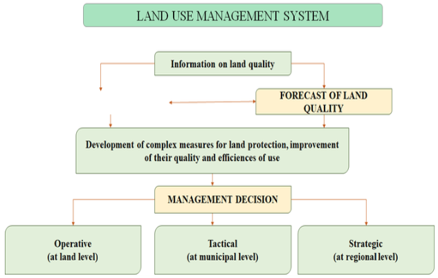
This technique is developed on the basis of the mechanism of functioning of municipal areas, the analysis of the contents and methodical bases of development of schemes of territorial planning and land management, the analysis of landscape and ecological approach that will promote the rational organization of use of land resources and formation of sustainable development of the administrative area (Shemyakina, Simakova, 2018; Evtushkova, 2018; Molchanova, Yurlova, 2016).
Tyumen region is the administrative-territorial and municipal formation in the Tyumen region of Russia.
The area of the district is 3.7 thousand km2. On the territory of the district there are rivers Tura-260 kilometers, Pyshma-150 kilometers. Part of the area is 77 settlements.
For the composition of the land Fund of the Tyumen area is characterized by the following relationship: a large part of the territory (64,06%) is occupied by forest lands, agricultural land make up 28.35%, lands of settlements – 1.34%, lands of industry, transport and other special purposes – 0,39%, water fund - 2.98%, stock earth -2,86%, lands of specially protected territories and objects - 0.01%.
Control of the content of heavy metals (lead, zinc, copper) in the soils of the Tyumen region according to the agrochemical survey was carried out in 2 rounds.
Low and average zinc content in the soil was established on the area of 65188.9 ha and 66 ha of arable land. Low content of zinc fixed on 47736,2 ha, and the average for 822,1 hectares of arable land.
Analysis of the qualitative state of the soil showed that the content of heavy metals in the soils of the Tyumen region does not exceed the established norm, the average content of lead, zinc and copper in the soil recorded on an area of 5643.3 hectares of arable land, above the norm is only the value of copper on 28 hectares of arable land. The acidity of the soil is mounted on 21 480,8 hectares of arable land. Low humus content was 17,9% - this is 8740.6 hectares of arable land.
The carried out landscape-ecological zoning allowed to establish violations in use of lands of the investigated territory (figure 2, table 1).
Figure 2
Landscape-ecological zoning of the territory of Tyumen region
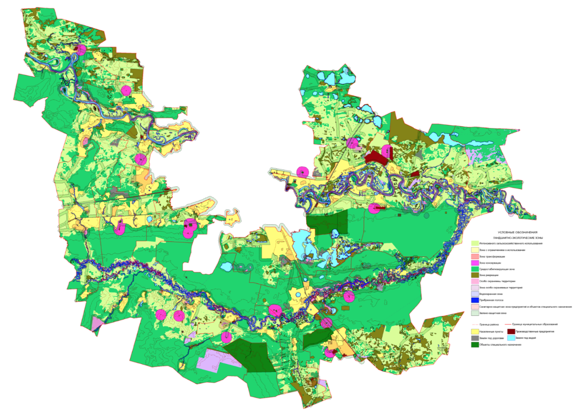
Note. Compiled by the authors
-----
Table 1
Landscape-ecological zones of Tyumen region
Landscape-ecological zone and subzone |
Purpose, land |
Area, ha |
Intensive agricultural use |
Arable Land, Deposit, hayfields, pastures of satisfactory ecological condition and weak ecological tension |
100 847,68 |
With restrictions on use |
Regulation of economic use |
|
Limitations associated with the ecological-economic condition of the lands |
Lands of medium environmental stress, where the average pronounced negative natural and anthropogenic processes: medium eroded, medium washed, medium saline, on the humus content and the capacity of the soil cover |
22 331,80 |
Recovery |
Recovery of the productive capacities of the land |
4450,11 |
Improving |
Land strong environmental stress, where the strong pronounced negative natural and anthropogenic processes: strongly saline, strongly eroded, strongly washed, medium marsh and other |
- |
Transformation |
Areas of areable land strongly washed, srtongly saline, marsh, as well as ereas of burning, cutting, suitable for afforestation |
4450,11 |
Conservation |
Restoration of land in a natural way |
17 498,99 |
Recreation |
For the purpose of internal andexternal recreation |
34029,53 |
Water protection |
Protection of water bodies |
36 133,9 |
Greenfield |
Reducing the negative impact |
97 448,25 |
Sanitary protection |
Reducing the negative impact of recycling facilities and industry, cemetery |
17 498,99 |
Specially protected objects |
Nature reserves, natural monuments, areas of distribution of specially protected objects |
606,47 |
Security |
Around nature reserves, monuments of nature, history and culture.Around (along) forest pegs, interspersed in arable land |
6 867,23 |
Medium-stabilizing |
Forests of the first group, swamps, lakes |
208 747,25 |
Note. Compiled by the authors
Violations established as a result of landscape-ecological zoning of Tyumen region:
1. Harmful influence on water objects is applied enterprise special and industrial purposes these include burial grounds, landfills landfills and cemeteries, which is equivalent to the imposition of a sanitary-protective zone on vodoohranoy area and coastal strip.
2. Environmental protection is carried out not only in the form of the organization of the use of natural resources, but also through the complete or partial removal of natural complexes and objects of environmental protection, as the inviolability of the natural environment, habitats of plants and animals, interesting and unique natural formations. The legal regime of specially protected areas is the creation of protected areas or districts with a limited regime of nature management in order to protect against adverse human impacts. Violation of land use within the boundaries of water bodies and established areas of specially protected natural areas.
3. The water protection zone includes the area near the reservoir, which is subject to a number of restrictions on the use of these areas. The main purpose of the introduction of these zones is to protect water resources from pollution. Established the presence of existing residential buildings in the water protection zone of Tura river.
Organization of use of land resources of the Tyumen region showed that the study area is not used in accordance with the established requirements, which leads to a decrease in soil fertility and low profitability.
Mathematical processing of the estimates, data and ranking of the district was carried out using the method of cluster analysis.
For the method of cluster analysis, the homogeneity of the population is not a prerequisite. Moreover, the method allows to identify and describe structural patterns, ensuring the formation of homogeneous classes in objects.
160 evaluation sites have been formed in the district. For each type of assessment in the context of indicators, a corresponding scale has been developed, with respect to which each site has its own score.
The results of the environmental assessment of agricultural lands of the Tyumen region showed that its territory was included in three clusters, characterized by a corresponding score on the level of environmental friendliness. The first cluster (not favorable) includes 52 evaluation sites, the second cluster (relatively favorable) – 54 sites and the third cluster (favorable) – 54 evaluation sites.
The unfavorable zone is observed on the territory of 26 farms, the indicators of which vary from 0.9 to 22%.
A relatively favorable zone is established on the territory of all farms and ranges from 5.3-50.9%.
In General, it can be concluded that the agricultural land of the Tyumen region is favorable for agricultural production.
On the basis of the analysis of agricultural land use in the Tyumen region, a correlation analysis of statistical data taking into account the physical and biological indicators of the studied land use.
Correlation analysis of statistical data was carried out in order to establish the reliability of data between agrochemical indicators and yields in the territory of land use of the Tyumen region.
In General, it can be concluded that the statistical relationship between the indicators is weak, but reliable, only a few indicators are more pronounced than others (figure 3).
Figure 3
Graph of the relationship between humus and acidity on yield
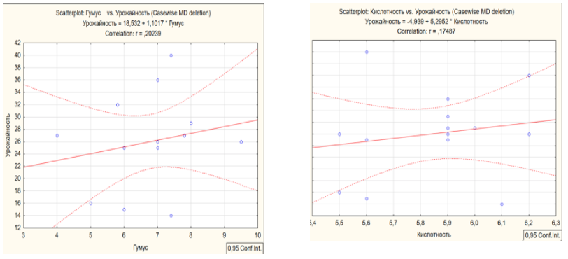
Note. Compiled by the authors
A positive correlation is observed between humus, acidity and yield, which suggests that the relationship is direct. A negative correlation is established between heavy metals and the yield of products.
1. The conducted landscape-ecological zoning of the Tyumen region allows to ensure the protection of land. All zones are aimed at the preservation of land in the process of their use, and the regimes of their use are established taking into account the protection of natural resources. The maximum area is occupied by the medium-stabilizing zone-38.2%, which includes the forests of the first group, swamp, water bodies, and the lowest percentage occupies specially protected areas – 0.1% of the total area of the district.
2. The results of the environmental assessment of agricultural lands of the Tyumen region showed that its territory was included in three clusters, characterized by a corresponding score on the level of environmental friendliness. The first cluster (unfavorable) includes 52 evaluation sites, the second cluster (relatively favorable) – 54 sites and the third cluster (favorable) – 54 evaluation sites. In General, it can be concluded that the agricultural land of the Tyumen region is favorable for agricultural production.
3. Mathematical processing of the data showed a positive correlation between the main data reflecting the qualitative state of the land.
4. Based on the analysis, the recommendations aimed at the rational use of land resources of the Tyumen region are proposed:
- to carry out timely control over the use of land, which will identify violations and reduce the area of disturbed land;
- in order to reduce the negative impact of industrial facilities on agricultural land and water bodies, it is necessary to provide for their transfer to the reserve territory for the future development of this territory;
- for the purpose of rational use of agricultural land it is necessary to develop projects of intra-farm land management of land holdings that are part of the study area, taking into account the landscape and environmental zoning;
- implementation of agrotechnological activities to improve the condition of the soil.
Pashnina, E.A., Simakova, T.V. (2017). Analysis of the use of reclaimed lands of the Tarman marsh massif of the Tyumen region. In the book: Topical issues of science and economy: new challenges and solutions. The Collection of materials LI international student scientific and practical conference. P. 116-119.
Starovoitova, E.S., Simakova, T.V. (2017). Organization of agricultural land use in Tyumen region. In the book: Current issues of science and economy: new challenges and solutions. The Collection of materials LI International student scientific-practical conference. P. 141-143.
Simakova, T.V., Skipin, L.N. (2015). State of land resources on the territory of the Federal landfill of state land monitoring «Nizhnetavdinsky» Tyumen region, Bulletin of the Krasnoyarsk state agrarian University. № 8. P. 33-37.
Simakova, T.V., Podkovyrovа, M.A., Oleynik, A.M. (2015). Formation of territories of sustainable development: methods and practice of land management and urban planning / agro-Food policy of Russia. № 5 (17). P. 24-27.
Skipin, L.N., Petuhova, V.S., Romanenko, E.A. (2017). Creation of favourable water - physical properties of drill cuttings with the use of coagulants / in the book: Procedia Engineering. P. 593-597.
Gaevaya, E.V., Skipin, L.N., Zakharova, E.V. Bogaychuk, Y.E., Tarasova, S.S. (2017). Utilization of drilling cuttings with extraction of ground for recultivation of disturbed soils / In the book: IOP Conference Series: Earth and Environmental Science Ser. «Innovations and Prospects of Development of Mining Machinery and Electrical Engineering - Mining Ecology». P. 042003.
Simakova, T.V., Skipin, L.N. Monitoring of reclaimed land in Tyumen region. Revista Espacios. Vol. 39. 2018. No. 14. P. 22. Retrieved from: http://www.revistaespacios.com/a18v39n14/18391422.html
Podkovyrova, M.A., Oleynik, A.M., Matveeva, A.A. (2018). Landscape-ecological approach to optimization of natural-management systems of administrative districts / International journal of civil engineering and technology. Vol. 9. No. 7. P. 513-521.
Shakhova, O.A., Sannikova, N.V. (2016). Assessment of the level of negative impact on the condition of the lands south of the Tyumen region / agro-food policy of Russia. № 12 (60). P. 58-62.
Maslov, F.S., Simakova, T.V. (2018). Current status and use of agricultural land in the kurgan region / in the book: Current issues of science and economy: new challenges and solutions. The LII collection of materials of International scientific-practical conference. P. 134-139.
Shemyakina, A.S., Simakova, T.V. (2018). Analysis of the condition and use of the reclaimed land of the tyumen region / in the book: current issues of science and economy: new challenges and solutions. The LII collection of materials of International scientific-practical conference. P. 204-209.
Evtushkova, E.P. (2018). Sustainable land management as a basis of formation of effective agricultural production / collector: collected papers of II all-Russian (national) scientific-practical conference «Modern scientific-practical solutions in agriculture» State agrarian University of Northern Trans-Urals. Tyumen. P. 176-184.
Yurlova, A.A. (2017). Reclamation of agricultural lands of the Yamal-Nenets Autonomous district of Tyumen region on the example of the SAND PITS / In the book: Modern scientific and practical solutions in agriculture. The Collection of articles all-Russian scientific-practical conference. P. 946-960.
Molchanova, E.A., Yurlova, A.A. (2016). Analysis of the formation of sustainable land-use in the process of territorial planning and land management (on materials of Tobolsk, Abalak MO area) / in the book: Current issues of science and economy: new challenges and solutions. The Collection of materials L International student scientific-practical conference. P. 671-675.
Kryakhtunov, A.V., Kravchenko, E.G., Pelymskii, O.V. (2014). Development strategy of the market of agricultural land on the example of the ishim municipal district of Tyumen region / Modern problems of science and education. No. 5. P. 307.
1. Nothern Trans-Ural State Agricultural University, Republic street 7, Tyumen, Russia. Contact Email: simakova.tamara@mail.ru
2. Nothern Trans-Ural State Agricultural University, Republic street 7, Tyumen, Russia
3. Tyumen industrial University, Volodarsky street 38, Tyumen, Russia
4. Tyumen industrial University, Volodarsky street 38, Tyumen, Russia
5. Nothern Trans-Ural State Agricultural University, Republic street 7, Tyumen, Russia