![]() ISSN 0798 1015
ISSN 0798 1015

![]() ISSN 0798 1015
ISSN 0798 1015
Vol. 41 (Issue 07) Year 2020. Page 3
KAZAKOV Mikhail Y. 1
Received: 20/07/2019 • Approved: 14/02/2020 • Published 05/03/2020
ABSTRACT: The relevance of this research is associated with the increasing demand from regions for the proprietary solution and implementation of a comprehensive socio-economic policy for balanced territorial development considering spatial trends in their dynamics. The subject and target focus of this research consists in creating a spatial analysis methodology for the development of peripheries complementing the methodological support for comprehensive diagnosis of issues in their functioning. The research aims to eliminate methodological deficiencies in the systemic study of spatial economic transformations in agro-industrial regions. |
RESUMEN: La pertinencia de esta investigación está asociada con la creciente demanda de las regiones de una solución patentada y la aplicación de una política socioeconómica integral para un desarrollo territorial equilibrado, teniendo en cuenta las tendencias espaciales en su dinámica. El objetivo y el tema central consiste en la creación de una metodología de análisis espacial para el desarrollo de las periferias que complemente el apoyo metodológico para el diagnóstico integral de los problemas en su funcionamiento. El objetivo final es el de eliminar las deficiencias metodológicas en el estudio sistémico de las transformaciones económicas espaciales en las regiones agroindustriales. |

Territorial (spatial) operating conditions of regional socio-economic systems in southern Russia are of particular scientific and practical interest regarding the formulation of balanced policies of socio-economic development (Mishchenko & Mishchenko , 2011; Nefedova , 2008). Accordingly, there is a need to develop approaches for analyzing and diagnosing the socio-economic differentiation of territories in the region within the core-periphery pattern. Identification of spatial characteristics for the central region of southern Russia will clarify the structural characteristics of the organization of regional settlements in terms of the communication accessibility as a key parameter for spatial analysis.
In any region, there is an administrative centre having a significant impact on the socio-economic development level of other peripheral territorial formations. However, the study of spatial characteristics for some territories proves that development momentum comes not only from administrative centres but also from the interaction between the objects. According to the suggested analyzing technique, to define the presence of these additional operating conditions all the settlements (district centres, urban district centres) are treated as peripheries, i.e. localities at a long distance from the regional centre.
The scientific justification for the new methodology of system-diagnostic research regarding the core-peripheral patterns of regions of southern Russian involves spatial analysis to confirm the attributing the territories to the periphery organization levels: near, middle and far. Such necessity is determined by the essence of our hypothesis concerning the correlation between the distance of the locality from the regional centre and its socio-economic development level: the farther from the centre, the worse its socio-economic characteristics. This hypothesis needs to be verified thus determining the relevance of the research and outlining its subject sphere.
Numerous contemporary studies consider the periphery within the regional system from the viewpoint of its remoteness from administrative, industrial and shopping centres. Their impact on the socio-economic development of territories is both direct and indirect (Panasyuk & Rudenko , 2008, ; Starodubrovskaya , 2014; Barau , 2017; Lind, 2018). In terms of remoteness, one can distinguish the far periphery, the middle periphery and the near periphery. Differences in approaches are defined by the scientific research area and closely related to the application field of research results.
As a method of territorial complex diagnostics, the spatial analysis includes the necessity to analyze the region in terms of identifying the distinguished groups of peripheries. To achieve the objective, we selected a method of economic and geographical analysis based on König index technique and the actual distance of the shortest road-route between the points of the intra-regional resettlement system (Harari , 2003; ( Sabidussi, 1966). The advantage of this approach lies in the option to ignore the influence of the territorial core on the spatial characteristics of peripheries.
As the object of the research, we selected the Krasnodar territory as the region of agro-industrial type. With a high degree of representativeness, conclusions obtained on its factual basis can be extended to the whole range of similar territorial authorities of southern Russia. The spatial determinants of territorial development were intensively considered in the research, notably the border localization of the settlement with the neighbouring regions, railway connection availability, presence of federal through roads. All that was reflected in the topological mapping.
To identify the areal peripherality of the Krasnodar territory relating to the agro-industrial regions, we drew a chart of main settlements in the region (Figure 1) at the first stage. The following spatial factors were taken into account: the border localization of the settlement with neighbouring regions creating advantages for establishing trade, tourism and other links (F1); the railway connection improves accessibility and provides additional positive effects (F2); the presence of federal through roads (F3).
The historical heritage has formed the modern structure of the regional resettlement, whereas the space transformation is of a perennial nature depending on many factors that impact the transport network reformatting. Assessment of the peripherality degree according to the distance from the administrative centre, in our opinion, precludes considering the region as a single and interacting area. Since the objects receive socio-economic momentum for the development not only from a regional centre but also from neighbour objects within the region as well as interregional cumulative fields. We use the König index. This technique involves ranking peripheries by the degree of their accessibility applying a topological diagram (Tolstoguzov , 2010). According to the methodology, the diagram is a graph containing fictitious peaks (settlements) and ribs (intersections). In this case, asphalt-paved roads are selected as a reference. The minimum total point value belongs to an object with a central position (degree of accessibility), whereas subsequent values get farther from the central point and can be both the middle and far peripheries. In the process of analysis, several accessibility indicators are calculated to assess the transport and geographic location of each object without reference to an administrative centre. This approach reveals the primary spatial archetype of peripheries from the standpoint of transport and economic characteristics. To confirm the correctness of operations, the Bavelas centrality index and the Beauchamp index were additionally calculated taking into account the overall results of the accessibility of settlements. Additionally, the graph method allows identifying additional spatial characteristics of territories such as an integration index (Ii) and a centralization index (Ic).
Calculating actual distances between the analyzed objects would enable ranging al lof them into three groups depending on the accessibility of the regional objects: near, middle and far periphery. In the summary table for the Krasnodar territory the groups of peripheries are represented in terms of two approaches: according to the number of points on the diagram and the actual distance between objects.
Figure 1
Positional diagram of settlements in the Krasnodar
territory on road graph (created by author)
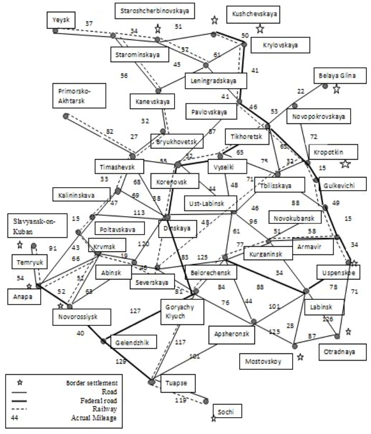
At the second stage, the calculation of the König index enabled identifying the central node of the periphery. The minimum number of points from the most remote peaks (5) was recorded for Dinskaya village, Timashevsk and Korenovsk cities. According to the sum of points, it is appropriate to add Ust-Labinsk city to this group due to the minimum value of the total accessibility index (117). The calculation of Bavelas and Beauchamp indices confirms the centrality of the four indicated settlements. The developed regional railway network draws attention as an additional factor of transport accessibility (Table 1).
The integration index of settlements into the regional space has an average value of 86.2, whereas its significant excess is recorded for the following peaks: Yeysk city (134); Starosherbinovskaya village (119); Temryuk city (119); Belaya Glina city (118.5).
The centralization index calculated according to actual distances has an average level of 2,803 km with a wide spread of values from 104 to 9866 km. This distance gap leads to the conclusion that the territory is decentralized with the presence of separate peaks: Sochi city (9866); Temryuk city (6863); Otradnaya village (6585).
Table 1
Calculation results for indicators of economic and geographical
territorial connectivity in the Krasnodar territory
|
Settlement |
Indicators of regional economic-geographical networks |
||||||||||
König index/ Accessibility index |
F1 |
F2 |
F3 |
Bavelas centrality index |
Beauchamp |
Integration |
Centralization index |
Actual distance accessibility index |
||||
1 |
Yeysk |
9 |
268 |
- |
+ |
- |
27,69 |
0,16 |
134,0 |
4806 |
11577 |
M |
2 |
Staroshcher-binovskaya |
9 |
239 |
+ |
+ |
- |
31,05 |
0,18 |
119,5 |
3453 |
10224 |
M |
3 |
Kushchevskaya |
9 |
210 |
+ |
+ |
+ |
35,33 |
0,20 |
105,0 |
4136 |
10907 |
M |
4 |
Starominskaya |
9 |
226 |
- |
+ |
- |
32,83 |
0,19 |
113,0 |
3152 |
9923 |
N |
5 |
Krylovskaya |
8 |
198 |
+ |
+ |
+ |
37,47 |
0,21 |
99,0 |
2282 |
9053 |
N |
6 |
Belaya Glina |
9 |
237 |
+ |
- |
- |
31,31 |
0,18 |
118,5 |
3696 |
10467 |
M |
7 |
Primorsko-Akhtarsk |
6 |
179 |
- |
+ |
- |
41,45 |
0,23 |
89,5 |
4086 |
10857 |
M |
8 |
Leningradskaya |
8 |
193 |
- |
+ |
- |
38,45 |
0,22 |
96,5 |
2405 |
9176 |
N |
9 |
Kanevskaya |
7 |
190 |
- |
+ |
- |
39,05 |
0,22 |
95,0 |
1748 |
8519 |
N |
10 |
Pavlovskaya |
6 |
138 |
- |
+ |
+ |
53,77 |
0,30 |
69,0 |
1364 |
8135 |
N |
11 |
Bryukhovetskaya |
6 |
167 |
- |
+ |
- |
44,43 |
0,25 |
83,5 |
1410 |
8181 |
N |
12 |
Tikhoretsk |
7 |
152 |
- |
+ |
+ |
48,82 |
0,28 |
76,0 |
1462 |
8233 |
N |
13 |
Novopokrov-skaya |
8 |
190 |
- |
- |
- |
39,05 |
0,22 |
95,0 |
2411 |
9182 |
N |
14 |
Timashevsk |
5 |
134 |
- |
+ |
- |
55,37 |
0,31 |
67,0 |
636 |
7407 |
N |
15 |
Kalininskaya |
6 |
143 |
- |
+ |
- |
51,89 |
0,29 |
71,5 |
912 |
7683 |
N |
16 |
Korenovsk |
5 |
123 |
- |
+ |
+ |
60,33 |
0,34 |
61,5 |
0 |
6771 |
N |
17 |
Vyselki |
7 |
138 |
- |
+ |
+ |
53,77 |
0,30 |
69,0 |
420 |
7191 |
N |
18 |
Tbilisskaya |
7 |
138 |
- |
- |
- |
53,77 |
0,30 |
69,0 |
872 |
7643 |
N |
19 |
Kropotkin |
7 |
166 |
+ |
+ |
+ |
44,70 |
0,25 |
83,0 |
1259 |
8030 |
N |
20 |
Gulkevichi |
8 |
184 |
- |
+ |
+ |
40,33 |
0,23 |
92,0 |
1479 |
8250 |
N |
21 |
Novokubansk |
8 |
161 |
- |
+ |
+ |
46,09 |
0,26 |
80,5 |
2491 |
9262 |
N |
22 |
Armavir |
8 |
172 |
- |
+ |
+ |
43,14 |
0,24 |
86,0 |
2858 |
9629 |
N |
23 |
Uspenskoe |
9 |
190 |
+ |
+ |
+ |
39,05 |
0,22 |
95,0 |
3382 |
10153 |
M |
24 |
Ust-Labinsk |
6 |
117 |
- |
+ |
- |
63,42 |
0,36 |
58,5 |
104 |
6875 |
N |
25 |
Dinskaya |
5 |
120 |
- |
+ |
+ |
61,83 |
0,35 |
60,0 |
135 |
6906 |
N |
26 |
Poltavskaya |
6 |
150 |
- |
+ |
- |
49,47 |
0,28 |
75,0 |
2248 |
9019 |
N |
27 |
Slavyansk-on-Kuban |
7 |
181 |
- |
+ |
- |
40,99 |
0,23 |
90,5 |
2606 |
9377 |
N |
28 |
Temryuk |
9 |
238 |
+ |
+ |
- |
31,18 |
0,18 |
119,0 |
6863 |
13634 |
F |
29 |
Krymsk |
8 |
176 |
- |
+ |
- |
42,16 |
0,24 |
88,0 |
2574 |
9345 |
N |
30 |
Abinsk |
7 |
144 |
- |
+ |
- |
51,53 |
0,29 |
72,0 |
2381 |
9152 |
N |
31 |
Severskaya |
7 |
152 |
- |
+ |
- |
48,82 |
0,28 |
76,0 |
3056 |
9827 |
N |
32 |
Belorechensk |
7 |
136 |
- |
+ |
- |
54,56 |
0,31 |
68,0 |
1130 |
7901 |
N |
33 |
Kurganinsk |
7 |
142 |
- |
+ |
- |
52,25 |
0,30 |
71,0 |
1988 |
8759 |
N |
34 |
Labinsk |
8 |
161 |
- |
- |
+ |
46,09 |
0,26 |
80,5 |
3009 |
9780 |
N |
35 |
Goryachy Klyuch |
7 |
130 |
- |
+ |
+ |
57,08 |
0,32 |
65,0 |
1645 |
8416 |
N |
36 |
Sochi |
9 |
199 |
+ |
+ |
- |
37,29 |
0,21 |
99,5 |
9866 |
16637 |
F |
37 |
Tuapse |
8 |
159 |
- |
+ |
+ |
46,67 |
0,26 |
79,5 |
4905 |
11676 |
M |
38 |
Gelendzhik |
8 |
158 |
- |
- |
+ |
46,96 |
0,27 |
79,0 |
5042 |
11813 |
M |
39 |
Novorossiysk |
9 |
182 |
+ |
+ |
+ |
40,77 |
0,23 |
91,0 |
4038 |
10809 |
M |
40 |
Anapa |
8 |
199 |
+ |
+ |
+ |
37,29 |
0,21 |
99,5 |
4907 |
11678 |
M |
41 |
Apsheronsk |
8 |
152 |
- |
- |
- |
48,82 |
0,28 |
76,0 |
2519 |
9290 |
N |
42 |
Otradnaya |
9 |
201 |
+ |
- |
- |
36,92 |
0,21 |
100,5 |
6585 |
13356 |
F |
43 |
Mostovskoy |
9 |
187 |
+ |
- |
- |
39,68 |
0,22 |
93,5 |
4242 |
11013 |
M |
At the third stage, the peripheries were arranged into three typological groups (near, middle and far peripheries). Three settlements were also identified in the far periphery (Otradnaya village, cities of Sochi and Temryuk).
The main array of objects (29) belongs to the near periphery group, which indicates the high density of settlements with different spatial characteristics but with a high degree of accessibility of each object (Table 2).
Table 2
Typological distribution of off-central territories according
to levels of peripheral organization in the Krasnodar territory
According to the quantity of points |
According to the actual distance |
||
Near periphery (117-167) |
Pavlovskaya |
Near periphery (6771-10060) |
Starominskaya |
Bryukhovetskaya |
Krylovskaya |
||
Tikhoretsk |
Leningradskaya |
||
Timashevsk |
Kanevskaya |
||
Kalininskaya |
Pavlovskaya |
||
Korenovsk |
Bryukhovetskaya |
||
Vyselki |
Tikhoretsk |
||
Tbilisskaya |
Novopokrovskaya |
||
Kropotkin |
Timashevsk |
||
Novokubansk |
Kalininskaya |
||
Ust-Labinsk |
Korenovsk |
||
Dinskaya |
Vyselki |
||
Poltavskaya |
Tbilisskaya |
||
Krymsk |
Kropotkin |
||
Abinsk |
Gulkevichi |
||
Severskaya |
Novokubansk |
||
Belorechensk |
Armavir |
||
Kurganinsk |
Ust-Labinsk |
||
Labinsk |
Dinskaya |
||
Tuapse |
Poltavskaya |
||
Gelendzhik |
Slavyansk-on-Kuban |
||
Apsheronsk |
Krymsk |
||
Middle periphery (168-217) |
Kushchevskaya |
Abinsk |
|
Krylovskaya |
Severskaya |
||
Primorsko-Akhtarsk |
Belorechensk |
||
Leningradskaya |
Kurganinsk |
||
Kanevskaya |
Labinsk |
||
Novopokrovskaya |
Goryachy Klyuch |
||
Gulkevichi |
Apsheronsk |
||
Armavir |
Middle periphery (10060-13349) |
Yeysk |
|
Uspenskoe |
Staroshcherbinovskaya |
||
Slavyansk-on-Kuban |
Kushchevskaya |
||
Krymsk |
Krylovskaya |
||
Sochi |
Belaya Glina |
||
Novorossiysk |
Uspenskoe |
||
Anapa |
Gelendzhik |
||
Otradnaya |
Novorossiysk |
||
Mostovskoy |
Anapa |
||
Far periphery (217-268) |
Yeysk |
Mostovskoy |
|
Staroshcherbinovskaya |
Tuapse |
||
Starominskaya |
Far periphery (13349-16638) |
Temryuk |
|
Belaya Glina |
Sochi |
||
Temryuk |
Otradnaya |
||
This fact indicates the network-based character of the economic space organization with a conditional uniform distribution of settlements and the absence of large "gaps" in its structure. The developed transport network facilitates the interaction of settlements and their economic agents that has a positive impact on the level and pace of socio-economic development of the territories.
The transport-geographical approach implemented through spatial analysis of the peripheries in the Krasnodar territory allows to formulate several conclusions and applied analytical summaries.
Number one. The settlements with the most economically advantageous transport position within the region are the cities of Ust-Labinsk, Timashevsk, Korenovsk and Dinskaya village. These peripheries objectively have a central localization and a high level of transport accessibility among all the settlements in the analyzed region thus increasing their spatial and economic potential. These additional factors allow ensuring the stability of transit maneuvers and optimization of logistical schemes in the freight and passenger traffic organization.
Number two. As a result of the research, a high level of territorial centralization and density was identified. It indicates dense resettlement within the territory and close cooperation of economic agents in the region. This fact promises additional economic effects due to benefits from the network-based character of the economic space organization in the analyzed region.
Number three. In this research, the remote settlements of the region were identified (Otradnaya village, cities of Sochi and Temryuk). These territories have additional development factors in the form of border localization and incoming railway networks. At the same time, the socio-economic capacity of these facilities will be different due to the presence of contact seaside borders in two of them (cities of Sochi and Temryuk), which significantly increases the competitiveness of the territories. A good example of this competitive territorial transformation is the Winter Olympics in Sochi in 2014.
During the discussion of the study results, it was determined that the approach proposed and implemented by the author in this article had its proven benefits. This approach to the identification of levels of peripheries according to the complex criterion of their proximity to the centre is a significant methodological addition to the existing scientific support for diagnosing the issues of the socio-economic territorial development (Gritsay , Ioffe , & Treivish, 1991; Zyryanov , 2008). It can also be applied to the development of appropriate activities under the adaptive and selective policy of territorial development.
The scientific community recommended conducting similar studies based not only on materials of the Krasnodar region but also all the regions of the agro-industrial specialization in southern Russia. The next step in the improvement of the spatial analysis methodology is supplementing the results of the studies (Hernandez, 2016; Givoni, 2017; Rokkan , 1987), formulated analytical conclusions as well as the empirical material introduced into scientific circulation by the author.
Conclusions. Summing up the research, it should be noted that the spatial structure of peripheries is an extremely dynamic phenomenon with all the statics of the geographical setting of localities. The research formed a methodological approach for delimitation (separation, allocation) of peripheries, which can be considered as a spatial analysis technique. As interpreted by the author, its distinctive feature is the synchronized use of König, Beauchamp and Bavelas indices with the combinative application of topological techniques and methods for reducing the multidimensional information array of the initial economic and geographical information. The spatial analysis of the regional territories carried out with this methodical support allowed to identify three zones of the periphery according to the set of spatial-transport characteristics: near, middle and far ones. The received, systematized and represented empirical data could be used by:
- federal authority and administration agencies for planning fiscal transfers and budgetary appropriations to support strategically relevant territories of the Black Sea coast of the Caucasus;
- the regional management system for elaborating and implementing activities of balanced spatial socio-economic policies of territorial development involving an equalization of infrastructural and institutional security, as well as social and economic well-being;
- research institutes of the Russian Academy of Sciences and higher education institutions in implementing analytical and fundamental works in this subject area;
- the corporate sector of the economy for planning strategic directions of its activities, formulating and adjusting the market strategy of operation and development in southern Russian regions.
Barau , A. (2017). Tension in the periphery: An analysis of spatial, public and corporate views on landscape change in Iskandar Malaysia. Landscape and Urban Planning(165), 256-266.
Givoni, M. (2017). Assessing core-periphery relation through travel patterns - The case of Israel .Volume 63, August 2017, Pages 73-85. Research in Transportation Economics(63), 73-85.
Gritsay , O. V., Ioffe , G. V., & Treivish, A. I. (1991). Center and periphery in regional development. Moscow: Science.
Harari , F. (2003). The theory of graphs. Moscow: URSS.
Hernandez, D. (2016). , Helena Titheridge Mobilities of the periphery: Informality, access and social exclusion in the urban fringe in Colombia. Journal of Transport Geography(55), 152-164.
Lind, J. (2018). Devolution, shifting centre-periphery relationships and conflict in north. Political Geography(63), 135-147.
Mishchenko , V. V., & Mishchenko , I. V. (2011). Development of intraregional rural space: the methodological aspect. Issues of state and municipal management, 4, 43-49.
Nefedova , T. G. (2008). The Russian periphery as a socio-economic phenomenon. Regional studies, 5, 14-31.
Panasyuk , M. V., & Rudenko , A. (2008). Analysis of the development of the "center-periphery" systems of the region (on the example of the Republic of Tatarstan). Izvestiya of the Russian Academy of Sciences. Geographic series, 1, 60-72.
Rokkan , S. (1987). The center-periphery polarity. Center periphery structures in Europe: an ISSC workbook in comparative analtsis. Frankfurt a.M./ N.Y: Campus Verl.
Sabidussi, G. (1966). The centrality index of a grapf. Psychometrika, 31(4), 581-603.
Starodubrovskaya , I. V. (2014). Social policy in peripheral territories. Actual problems. Moscow: Publishing house "Delo".
Tolstoguzov , O. V. (2010). Typology of peripheral territories and features of the boundary periphery of the Northwest of Russia. Regional economy: theory and practice, 47(210), 5-13.
Zyryanov , A. (2008). Marginal territories. -. Perm: Publishing House Of The Perm University.
1. FSAEI HE Belgorod National Research University. Russia Federation. Email: lyasay21@yandex.ru
[Index]
revistaespacios.com

This work is under a Creative Commons Attribution-
NonCommercial 4.0 International License